Hello, Can you please tell me how to find the baseline length between two interferometric images in SNAP?
from RADAR ----> Interferometric--------->stack overview
I found this function, but what value is responsible for the length of the baseline?
The Bper or perpendicular baseline length selection is according to the goal of your study, So if you intend to achieve displacement in this case lower than 200 m is recommended, also here the slope in your study area plays an important role. In case you intend to create DEM more than 200 m, is recommended.
Please take a look at the following link you could find more information
Thanks for the info! For the length of the baseline in the stack overview, the indicator “Heigth Ambg” answers?
Thanks, I took three different sites for building a displacement map and everywhere the indicator Bperp I have a negative:
Bperp = -46,22
Bperp = -78,99
Bperp = -56,45
What does this mean? What images are not suitable for plotting displacement maps?
Taking the absolute number the smallest one the best, in your case is the first one,
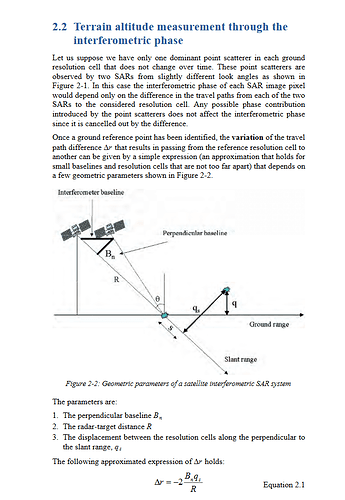
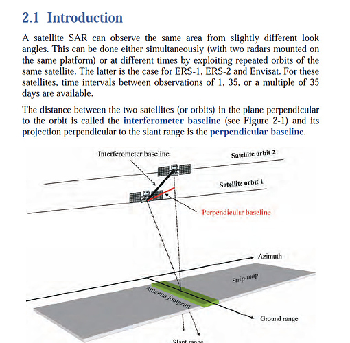
The negetive sign is resulted from the different of geometrical measurements between two satellite passes, please read the geometrical concepts of the Bper and you’ll find out yourself what does this sign mean.
Maybe this presentation is also interesting to you. It explains how baseline and other factors potentially influence InSAR results:
https://saredu.dlr.de/unit/insar_errors
Thank you so much!
Where can I learn more about the parameter Bperp? As I understand it, it can be negative. For the displacement map, the value of Bperp should not be more than 200 m, right?
Hi, falahfakhri. I have tested many Sentinel-1A interferometry pairs, but I have not found any was large than 200m in terms of baseline. How do you think about this?
Would you please to rephrase this point [quote=“sentinelgyb, post:13, topic:6237”]
How do you think about this?
[/quote]
What do you mean?
I mean Is there any trick to choose the Sentinel-1A interferometry pairs with baseline larger than 200m? I have tested many Sentinel-1A interferometry pairs, but I have not found any was larger than 200m in terms of its baseline. Thanks
I am getting perpendicular baselines in negative (-20.35) with sentinel-1 data. I have a problem while removing topographic phase for displacement mapping. The interferogram is showing similar results before removing the topographic phase and after removing the topographic phase. Is baseline is the problem here? What shall I do? I need to find out the deformation map. Can anybody please explain? I have also used different DEMS here which are provided in this software.
I would consider 20 m as the very limit for interferometry. If both satellites have nearly the same position you cannot get a pronounced topographic phase.
Thank you so much. I have now considered both short and long baseline to see the difference.
Hello,i am facing the same problem these days.can you share with me about how do you find the
sentinel-1A pairs with a baseline more than 200m?
my email: li798210534@gmail.com


