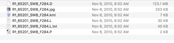
I downloaded some RADARSAT-1 data from the Alaskan Satellite Facility. I’ve had success calibrating, speckle filtering, and doing range-doppler terrain correction on ENVISAT and Sentinel 1 data in SNAP. However, I have no luck with the files included in the RADARSAT download (picture of included files attached). I can’t seem to find any tutorial on how to process RADARSAT-1 data with open-source software. Can the data be processed in SNAP? Am I downloading the right materials to create calibrated and terrain-corrected SAR images?
If anyone can recommend any resources that demonstrate how to process RADARSAT-1 data, or explain how to process it here, I would greatly appreciate it!
I didn’t download Radarsat-1 data from ASF so far, but are there different product levels to select for download? 123 MB don’t seem to be a full SAR product to me.
Thanks for your reply. I only see Level 1 imagery available through the ASF. 123MB file size doesn’t seem so bad… ENVISAT images are generally the same size in their downloadable format. All these files seem to contain information needed to process it into a SAR product, but I don’t know how, or if SNAP is able to do it.
Ah, you are right, I forgot to take into account that I was subsetting my ENVISAT data before processing it!
I did try importing radarsat data the way you suggested, but all of the files (in the picture attached to the original post) are greyed out. I also can’t add the entire folder or the zipped file (as you would with sentinel). I inspected all the files and it appears to have everything needed to process it into a SAR product, I wonder if another software platform is needed for RADARSAT data specifically.
Also perhaps I need to do something with the .D file before it can be imported into SNAP? I’ve never dealt with files like those so I didn’t consider that.
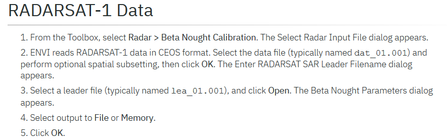
But you could play around using the procedure is mentioned in the following link might be possible applied by using ENVI, check up if could be applied in SNAP,
I downloaded from ASF
$ ls -C1
R1_36006_FN1_F427.D
R1_36006_FN1_F427.jpg
R1_36006_FN1_F427.kml
R1_36006_FN1_F427.L
R1_36006_FN1_F427.L.txt
R1_36006_FN1_F427.P