Hi everybody,
I have to fix a litle problem… I am unable to convert .KML latest L1c products tiles grid into .SHP. ( i tried ogr2ogr, online tools and other stuffs…).
If anyone with an expensive licence of FME or ArcGis (or a command line hero) could upload a shape with this layer, it will be great.
Thank you
i just tried
ogr2ogr S2A_grid.shp S2A_OPER_GIP_TILPAR_20150622T000000_21000101T000000_ZZ_0001.kml
and it worked quite fine.
Here is the resulting shapefile. I removed all attributes besides from the name in order to save space.
Edit: This could be of a previous version of the kml. I cannot guarantee that it is still valid.
2 Likes
Thank you very much Andreas, you save my life ( and my time!).
Maybe i have to fix ogr2ogr before… 
Thanks
Dear Andreas,
I am trying to use dataset you compute for me (thank you very much for your help).
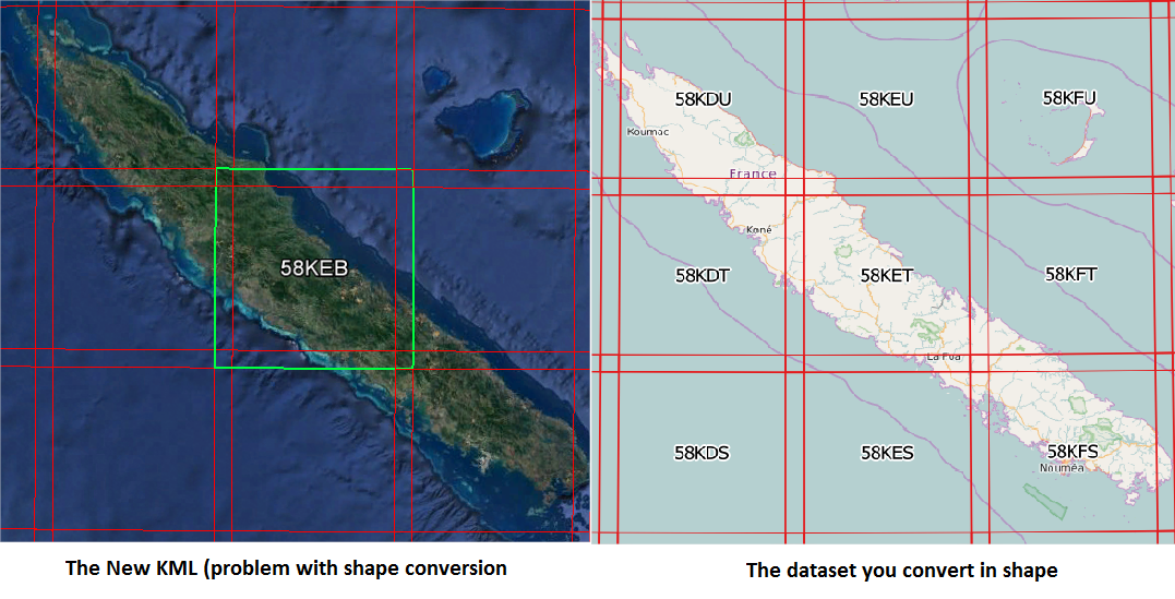
But i think you have used the old grid of S2 L1C…
I compare the kml i have just downloaded on esa S2 mission’s website, with the shape you have processed for me. And there is some difference with the name of tiles…
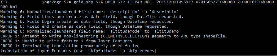
I have tried to compute the recent kml with your commandline, but i am still facing problems:
I hope this post help you to correct your own dataset.
If you have any ideas with my problem, i am still searching a solution…
Thank you Andreas
thanks for the reply.
Can you give me a link to the data you are using?
i am using this data (on esa portal), but i don’t know which dataset is wrong…
https://sentinel.esa.int/web/sentinel/missions/sentinel-2/news/-/asset_publisher/Ac0d/content/sentinel-2-level-1c-product-tiling-grid-released
Thank you Andreas
that is strange. This was the dataset I used but when I test it it seems correct.
kml
shp

@insight: I made it again, please test it on your side.
File removed
Hello,
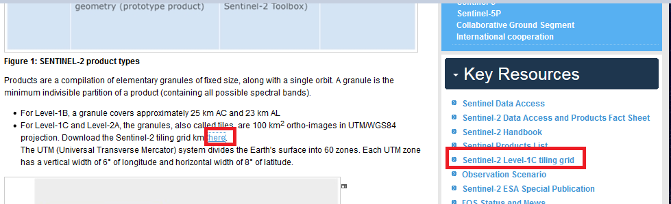
It appears that the Tiling Grid you are using is not the most up to date version. This can be found in the Mission Guide ‘Key Resources’ portlet here https://sentinel.esa.int/web/sentinel/missions/sentinel-2/
The Tilin Grid was updated in September 2015. See this News Item:
Cheers
Jan
S2 MPC Operations Manager
thanks for clarification. Does this updated grid apply for all S2 products or only for those after 12.09.2015?
Ok,
It works perfectly fine on my qgis. My file was the wrong ( with the tile 58KEB)
Thank you Jan and Andreas for your assisstance in my quest of S2 Tiles.shp…
Cheers
alright, thank you. So this is the only valid remaining I guess:
https://sentinel.esa.int/web/sentinel/missions/sentinel-2/data-products
Hi,
I don’t understand what you mean by ‘valid remaining’. In my post S2 L1C Tiles Grid in shape I identified the location of the correct file as being under the Key Resources in the Mission Guide.
The link in the text and the link in the Key Resources point to the same version of the file.
Jan
Dear Jan,
if you search it via Google, for example, you also find this page:
https://sentinel.esa.int/web/sentinel/missions/sentinel-2/news/-/asset_publisher/Ac0d/content/sentinel-2-level-1c-product-tiling-grid-released
This is its name:
S2A_OPER_GIP_TILPAR_20150622T000000_21000101T000000_ZZ_0001.kml (111 MB)
and it can still be downloaded when you directly click on download. *
This is the name of the ony you posted:
S2A_OPER_GIP_TILPAR_MPC__20151209T095117_V20150622T000000_21000101T000000_B00.kml (103 MB)
And I wonder if they are the same. If not, you should probably remove the old one in order to prevent misunderstandings. I just ask because then I also should remove the shapefile I created above.
*Edit: This is no longer the case. See next post.
Hi,
Thanks for the info. I’ve checked with my ESA Technical Officer, and we have agreed to remove the older versions and so the current version (with the link on the Data Products page) is now the only one. I’ve also had the Data Products page updated to change the location of the link itself, to make it more ‘attractive’ to Google (other search engines are available).
I have been advised that It might take a few days for Google to register the changes, but that it should pick this all up at some point. Hopefully that will help remove any confusion.
Cheers
Jan
1 Like
thank you for your efforts, Jan!
1 Like
maybe this is interesting for some of you:
This guy also created a shapefile from the official kml.
Probably very old question… I had the same problem.
The right way to convert it to shp is
ogr2ogr -f "ESRI Shapefile" -nlt POLYGON S2_tiling.shp S2A_OPER_GIP_TILPAR_MPC__20151209T095117_V20150622T000000_21000101T000000_B00.kml