For water body extraction of a complex wetland area, either texture or db thresholding results in an overestimation of water class using the Radarsat2.
Is any other approach in SNAP recommended?
Thanks
For water body extraction of a complex wetland area, either texture or db thresholding results in an overestimation of water class using the Radarsat2.
Is any other approach in SNAP recommended?
Thanks
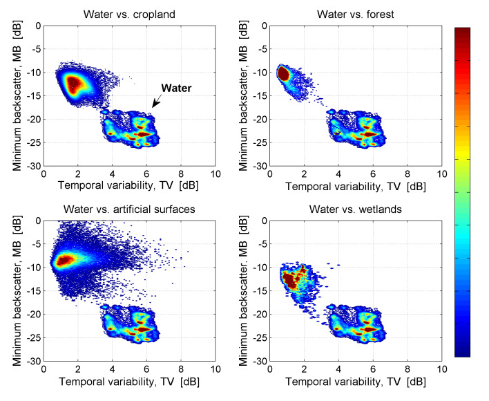
Instead of thresholding or textures, have you considered using stacks of time-series for the discrimination? A promising approach was presented by Santoro et al.
source:
http://due.esrin.esa.int/mwbs2015/files/2_Santoro.pdf
Thanks for sharing the link! Just wondering whether we can obtain the scatter plots in terms of “Minimum backscatter” vs. Temporal variability in SNAP? I have 40 SAR images (for temporal monitoring, surface water body).
This is possible with Radar > Coregistration > Stack Tools > Averaging
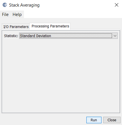
It allows calculating the minimum from a stack and some other measures. As for the temporal variability, you could use the standard deviation as it is also in the same unit as the input (db in this case).
I assume that Stack averaging does not accept the Terrain Corrected images, while it accepts the sigma0 (before geometrically corrected) in either linear or db unit.
But for the Statistics on sigma0 only “Mean Ave” can be produced. For the “Min or Max” I get the following error. And the output for the “std” is a black image!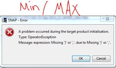 :
:
I have just checked the scatter plot in SNAP, it accepts one image vs another, how we get a temporal variation using multiple images?
Thanks again!
Terrain corrected images should be no problem. But maybe signs in your filenames are causing the error.
How are your bands named?
Hello,
Does the time series work fine on your SNAP? I tried to do a temporal variation graph from a stack with 4 SAR images, I added the coregistration stack with the temporal variability product together but it does not show any information on the graph =/