I would like to use S1 GRD data for change detection with SNAP (my research topic is changing of wetlands and inland shallow water). I hope that GRD data is good for me. I read a lot of forum topic here and some tutorials, but now I’am confused, because I didn’t find a detailed tutorial for S1 GRD data and SNAP (there are lot of SLC interferometry etc. tutorial) and the help of SNAP is not enough. It writes only a few words for each tools.
So, my question is that what is the appropriate sequence of running these tools?
I did this:
Make subset
Apply orbit file
Radiometric calibration
Speckle filtering
Terrain correction
Coregistration (DEM assisted)
Change detection
And my other question: What is the “remove thermal noise” and “radiometric terrain flattening” and when to run these tools?
You may not need the orbit correction or speckle filter and you may want to apply the terrain correction last just to export your result or show the results in a map.
Hi everyone,
I have a few question about change detection. Firstly, I use similar workflow as mentioned in the first post (GRD):
(0. Subset)
Apply Orbit File
Radiometric Calibration
DEM Assisted Corregistration
Change Detection
Terrain correction
As was mentioned in some posts, how could I correctly select threshold to select only significant/real changes ? I know I have to play with results and I have done many change detection to examine results, but are there by your experience values which can be connected with “real” changes. Is there some value which we can consider as high/low enough to say significant change happened ? If I have log ratio values from e.g. -6 to 6.
Is there some option how to filter results ? I have tried 10 different image pairs of different areas and a huge share of changes take place in agrucultural fields or water.
“Using SAR Coherent Change Detection technology (SAR-CCD), change maps are generated by comparing two radar images of the same geographic region, taken at different times. This highlights areas where a significant change has occurred between the two image dates.”
It is said Coherent Change Detection is used, based on answer from another topic (below), is it the algorithm used in change detection tool ? Name of the document in the answer below is Coherent Change Detection: Theoretical Description and Experimental Results.
Also I would like to ask, should I use GRD product (I use it now) or I should go for SLC product to get output as in the article if it could be said (resolution) ?
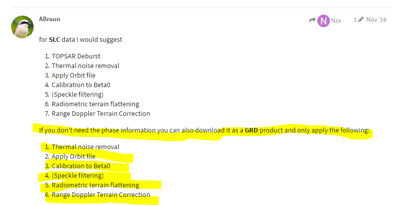
The GRD lets you retrieve amplitude change only. The SLC enables you to retrieve phase coherence change as well, which may be useful, depending on the retrieval task. SLC is not always available, but certainly the better choice. Even the loss of coherence can be a good indicator for your land use, e.g. vegetation regrowth.
GRD is good for change detection. unless you aim for coherence based approaches.
SLC is complex data and takes much larger space and processing time.
RAW is not focused yet and therefore not readable by SNAP.