yeah you are right… my location falls into IW2… i ve checked sub-swath IW2 of intensity_VV and intensity_VH images (from its lat and lon) but it is not pointing the intended coverage , again it points to the IW3 subswath… for all the passes the data size of SLC product is usually 7.02 GB or above is displayed in the product detail…but when i download the file size is shown as 4.35 GB… is there any mistake with downloading or its common…? where i do mistake? pls clarify…
thanking you …
Nathiya
~4.5 GB is the correct size when compressed as a zip file.
Ok thank you…any idea …? why sub-swath coverage IW1 and IW2 are missing when i locate with lat long…?
I don’t quite understand how you are trying to locate your corner reflector.
I don’t think the lat lon coordinates shown in the bottom right corner of SNAP as you move the mouse over a S1 SLC swath are correct.
I don’t know whether the coordinates shown by SNAP would be correct once you deburst and merge the swaths.
Alternatively, you can look at the annotation file of your swath (IW2) and try to find the closest geolocationGridPoint (by lat lon) to your CR location. Then look in the swath image around the line pixel coordinate of that grid point and try to find your CR. To be more accurate, find the four closest geolocationGridPoints and interpolate.
If there is an easier, more accurate way to go to a given geo location in a S1 SLC product in SNAP, I don’t know it.
Hi, A couple of suggestions (a) you should try the GRDH product to locate your area and see if your corner reflector is visible and (b) for the SLC product check that you have 6 tiff files and they are approximately the same size. In my experience dual polarisation IW SLC products (compressed as a tar file) are typically 8GB in size. Peter
Thank you… also there is a way to locate my file if i process the SLC Intensity files to produce a stitched, geocoded file it seems. But how to stitch the SLC file…
Dear Peter
your assumption is correct but in those six files vv and vh of each band are of same size but not all the 6… eg.IW1_VH n IW1_VV are of exact same size but IW2 of vv n vh are same like dat… but Mr.pete from copernicus team suggested to stich the intensity files using snap tool… can anyone guide me…? i am not much aware of snap tool…
Hi Nathiya, I would expect the file size of the two polarisations of IW1 to be the same but to be slightly different from the IW2 and IW3 file. The SNAP tool can be used to create the intensity version of the IW2 SLC files. You can download SNAP from http://step.esa.int/main/download/ - once installed you can read and display the SLC files. An online tutorial on how to use SNAP can be found at http://step.esa.int/main/doc/tutorials/ and in particular https://www.youtube.com/watch?v=10x7UI7oD3E.
I think it will be much easier to start with the GRDH version of your scene to find your location and corner reflector.
Agreed, since it’s possible that the corner reflector is misaligned and therefore invisible, checking whether it is visible at all on GRDH-products first is the prudent way to approach the issue.
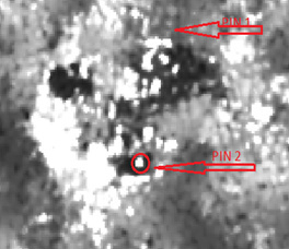
Thank you i ve located my corner reflector in the image (image is shown below two diff locations during two different passes) with all of your help in alignment procedure. I ve located my CR in GRDH image but i would like to do the same in SLC image … can anyone help me in explaining stitching of two(IW1 &IW2) SLC files… is all the GRDH images calibrated one…?
Thanks
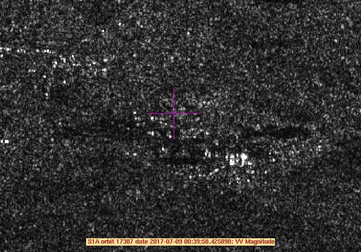
Hi, As your location is in IW sub-swath IW2, there is no need to join the IW sub-swaths together. I have obtained the SLC product for the acquisition over your location on 9th July and below is the region around Devarakaggalahalli. The purple cross is for location 12 38’ 36"N, 77 26’ 26" and terrain height 695 m. As you will see, there is no obvious point target near this cross in VV polarisation.
Could you confirm the type of corner reflector you were using (e.g. trihedral), the size of the corner reflector, its location for 9th July and the azimuth and elevation angles you used to orientate the corner reflector. You mention a second acquisitions - what date was this (and where was the corner reflector).
Both GRDH and SLC products are calibrated.
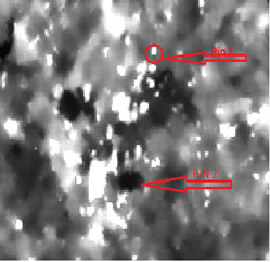
i ve located at 12deg 38’37" 77deg 26’23"… this is not the proper image but you can visualise it …can we able to visualise the sentinel image in matlab… i tried using small level of code and i got only this image…can anyone help me regarding this… thanks in advance

Hi, The image looks as if it from the SLC product where you are displaying the I and/or Q channels. Instead you need to create an amplitude image by using amplitude is = sqrt (II + QQ). In the SLC measurement file, the I and Q values are stored in order IQIQ etc. You can use SNAP to display the amplitude image for SLC products.
If you can provide information about your CR (size etc) I will be able to see if it is visible in the image.
thank u peter…the size is 60cm square trihedral… and the location is 12deg 38’16" 77deg 26’ 22"… recent deployment was on 26/08… anyone help me in opening matlab… i am trying to open using fopen n fread command… it displays like above image… how to extract for the particular pixel…? i want to know some any inbuilt command in matlab to open tiff files…
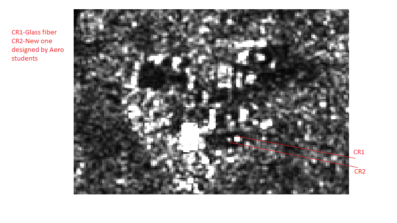
actually it is visible in the grdh image but not in slc… hence how to process and analyse it?where will i get information about the slc files…?
what is the platform you are using to view the image…? i am using snap tool itself…
Hi, A 60cm trihedral will give a RCS of just 22.47 dBm^2 which will be difficult but not impossible to detect in a IW product (for comparison a 1m trihedral give a RCS of 31.34 dBm^2) . I am obtaining the SLC product from 26th Aug and so will check the position you give (which appears to be a low backscatter region).
We use our own in-house software for analysing S1 products (not Matlab so I cannot help with this).
okay no problem… n i am using square trihedral so rcs is 32.0021 dbm^2 n i could make out my reflector in the image but in matlab i am finding a difficulty…trying my best …thanks for your support…
this is the image i ve located… and it is valid as well…
Hi Peter,
i ve checked the meta data of grdh file which says product type is ascii hence i use the precision in matlab as ‘char’ it shows me the black screen with out any salt n pepper image… i ve also tried with float n int precision… can you pls tell me which type of data it is…?
yeah i got the data precision it is uint8…thank you