I found that some of the SNAP exports may be missing:
This is the export:
According to mt_prep_gamma these structure is required

As you can see, the last folder dem is not included in the export.
Did any of you guys get this folder as well?
I found that some of the SNAP exports may be missing:
This is the export:
According to mt_prep_gamma these structure is required
As you can see, the last folder dem is not included in the export.
Did any of you guys get this folder as well?
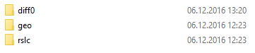
No, I have got 3 folders /diff0, /rslc, /geo. It seems that for some reason too many pixels with zero amplitude in mt_prep_gamma…
The *diff.par files are expected in the geo directory, but they currently are in the diff0 directory.
I moved them manually but it doesn’t make a change.
Whyt error message do you get, @katherine?
Hi!
I’m also testing this new tool.
I’ve gotten the same 3 folders that you have shown.
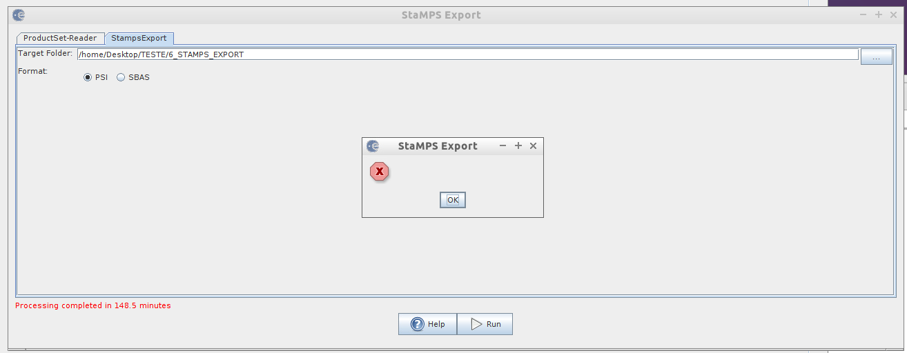
During the processing an error message appeared (see screen shot below). Did this happen to you? Maybe this message is related to the missing folder…
can you please show me the products you included in t he StaMPS export?
I had *diff.par files in the diff0 directory. And I had no error messages. I managed to go through all 8 steps of StaMPS. My problems were with plotting results and I also could not export ifgs after TopoPhaseRemoval so I just used for training ifgs with topophase not subtracted (after Interferogram formation funcionality).
great to hear that it works for you.
It would be nice if I could reproduce your workflow in order to getting a better understanding of the work-flow.
Could you please list the exact steps you performed in SNAP until the export? Also which and how much data you used.
These are the products from Snap which I exported to StaMPS. The second one is with elevation band added.
Katherine
ABraun
December 13
can you please show me the products you included in t he StaMPS export?Visit Topic or reply to this email to respond.
In Reply To
juanesburgo
December 13
Hi!
I’m also testing this new tool.
I’ve gotten the same 3 folders that you have shown.
During the processing an error message appeared (see screen shot below). Did this happen to you? Maybe this message is related to the missing folder… [image]
Visit Topic or reply to this email to respond.
To unsubscribe from these emails, click here .
All the best,
Katherine
sorry, this question was meant for juanesburgo
These are the steps I performed in SNAP. Hope this helps
1/ 12 S-1 images: Split and Apply_Orbit_File.
2/Create stack using Backgeocoding ( Radar-Coregistration-S-1Tops_Coregistration-S-1Backgeocoding. Master should be the first in the ProductSetReader)
3/Deburst the result of 2/
4/ Subset the result of 3/ (geographical coordinates) (Raster-Subset).
5/ Result of 4/ - Interferogram formation. I adde d elvation band to the result. I tried to apply TopoPhaseRemoval but export to StaMPS fuctionality did not work.
6/ The last step Radar-Interferometric-Psi/sbas-StaMPS export
I exported to StaMPS the two files: subset_master_Stack_Deb_ifg and subset_master_Stack_Deb .
The issue with the topo phase removal has been fixed and I’ll send an update by tomorrow. Sorry for this. For now you can rename the i and q band with i_ifg and q_ifg.
The problem with the map projected dem I’m still looking into. Stamps needs two dems, one in sar geometry and scene resolution in the geo folder and another map projected dem in the dem folder.
Thank you very very much, Luis! And what about binary raster files YYYYMMDD.lon YYYYMMDD.lat, containing one float32 value per pixel in master crop… They are necessary for PS geocoding…
All the best
Katherine
lveci
December 13
The issue with the topo phase removal has been fixed and I’ll send an update by tomorrow. Sorry for this. For now you can rename the i and q band with i_ifg and q_ifg.
The problem with the map projected dem I’m still looking into. Stamps needs two dems, one in sar geometry and scene resolution in the geo folder and another map projected dem in the dem folder.Visit Topic or reply to this email to respond.
In Reply To
katherine
December 13
These are the steps I performed in SNAP. Hope this helps
1/ 12 S-1 images: Split and Apply_Orbit_File. 2/Create stack using Backgeocoding ( Radar-Coregistration-S-1Tops_Coregistration-S-1Backgeocoding. Master should be the first in the ProductSetReader) 3/Deburst the result of 2/ 4/ Subset…
Visit Topic or reply to this email to respond.
To unsubscribe from these emails, click here .
All the best,
Katherine
I repeated the processing and this time everything went well.
But thank you anyway.
I have tried to rename all i and q bands into i_ifg and q_ifg in the product with topo phase removed, thus I could use export this product, but during 3-rd step in StaMPS were found 7 times more points, comparing to product with topo phase not removed, 99% of which were removed during ps weeding.
With update 5.0.1 the bands should be renamed already.
so how did you get StaMP installed under cygwin?
cd /cygdrive/c/temp/StaMPSmakemake installThis compiles the files which can be executed by the cygwin shell. You can run them with csh.
Some are also converted to exe-formats.
Same applies for the other packages.
well by installing im reffering to the other files like roi pac & doris if installing both from they owen respective packages those additional files located in stamps folder are used for what precisely?
Dear Jaroslav and other colleagues testing the workflow between SNAP and STAMPS,
One more problem. In STEP 2 of STAMPS I always have n_trial_wraps=0 (with or without topo phase removal).
n_trial_wraps is set automatically depending on the range of perpendicular baselines. So it seems that probably something is wrong with export of baselines as well… Or it is only my problem?
Katherine