Dear Abraun
I followed your tutorial about how to unwrapped phase using snaphu deal with cygwin, and it is successful, thank you.
however, how to use StaMPS in cygwin.
Thank you
jef
Dear Abraun
I followed your tutorial about how to unwrapped phase using snaphu deal with cygwin, and it is successful, thank you.
however, how to use StaMPS in cygwin.
Thank you
jef
Please have a look here:
At which step you are exporting these two bands? Lon/lat shall be orthocorrected but in SAR geometry.
The lon\lat export was added in preview 5 but there were some problems with exported bands. This is currently being fixed.
Dear mfitrzyk,
Thank you very much for your help!
I added longitude and latitude bands after TC and got subset_master_Stack_Deb_TC_lon_lat. Exported that to ENVI or GAMMA format. The results seemed reasonable.
It is my understanding that now in preview 5 we do not need to do TC but just export Stacks with subset_master_Stack_Deb (with lat and long bands added) and subset_master_Stack_Deb_ifg (with topophase removed) in radar coordinates to Stamps. Lat and long files should be renamed to .lon and .lat files. Am I right?
All the best,
Katherine
Dear katherine and all,
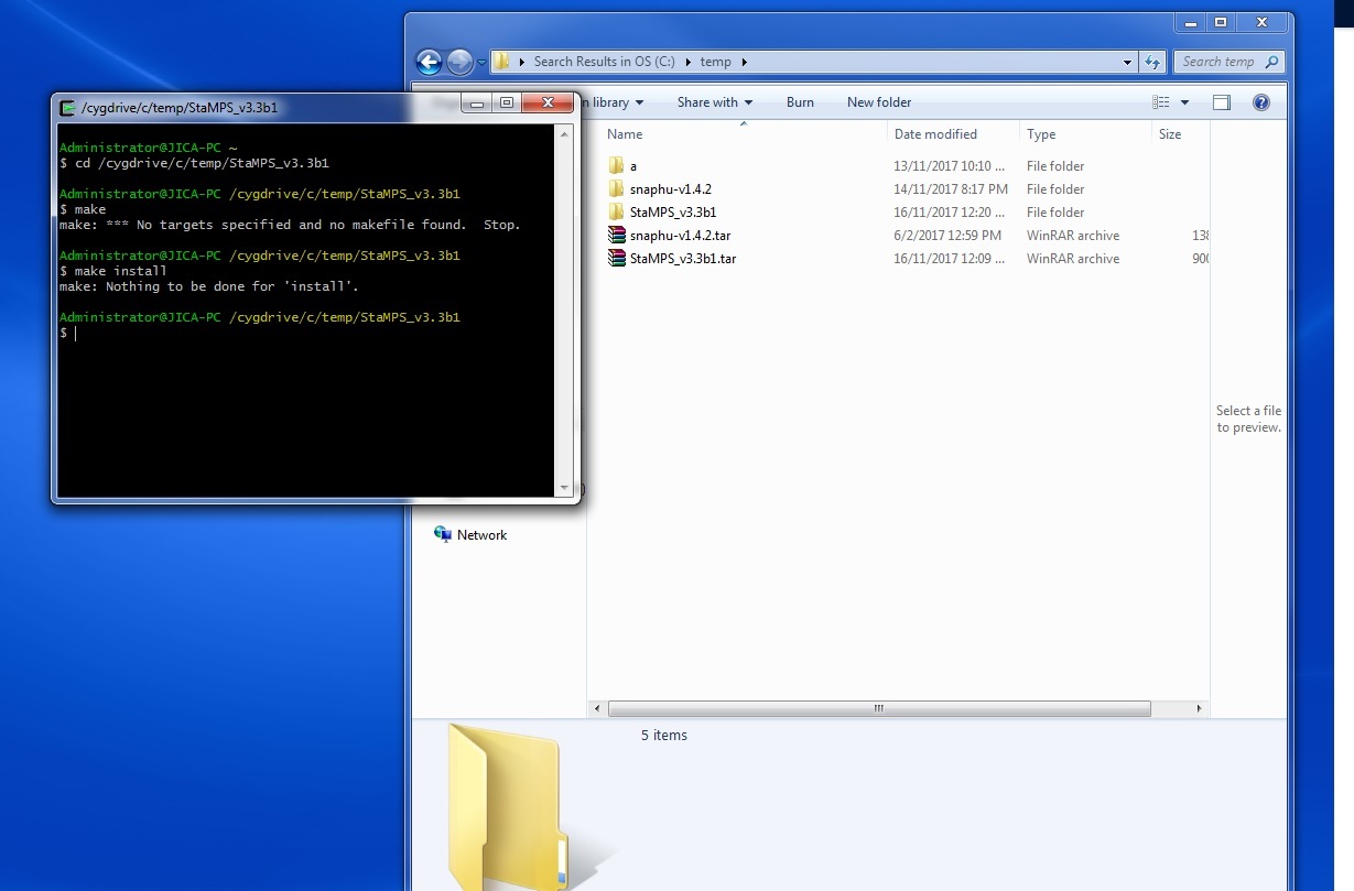
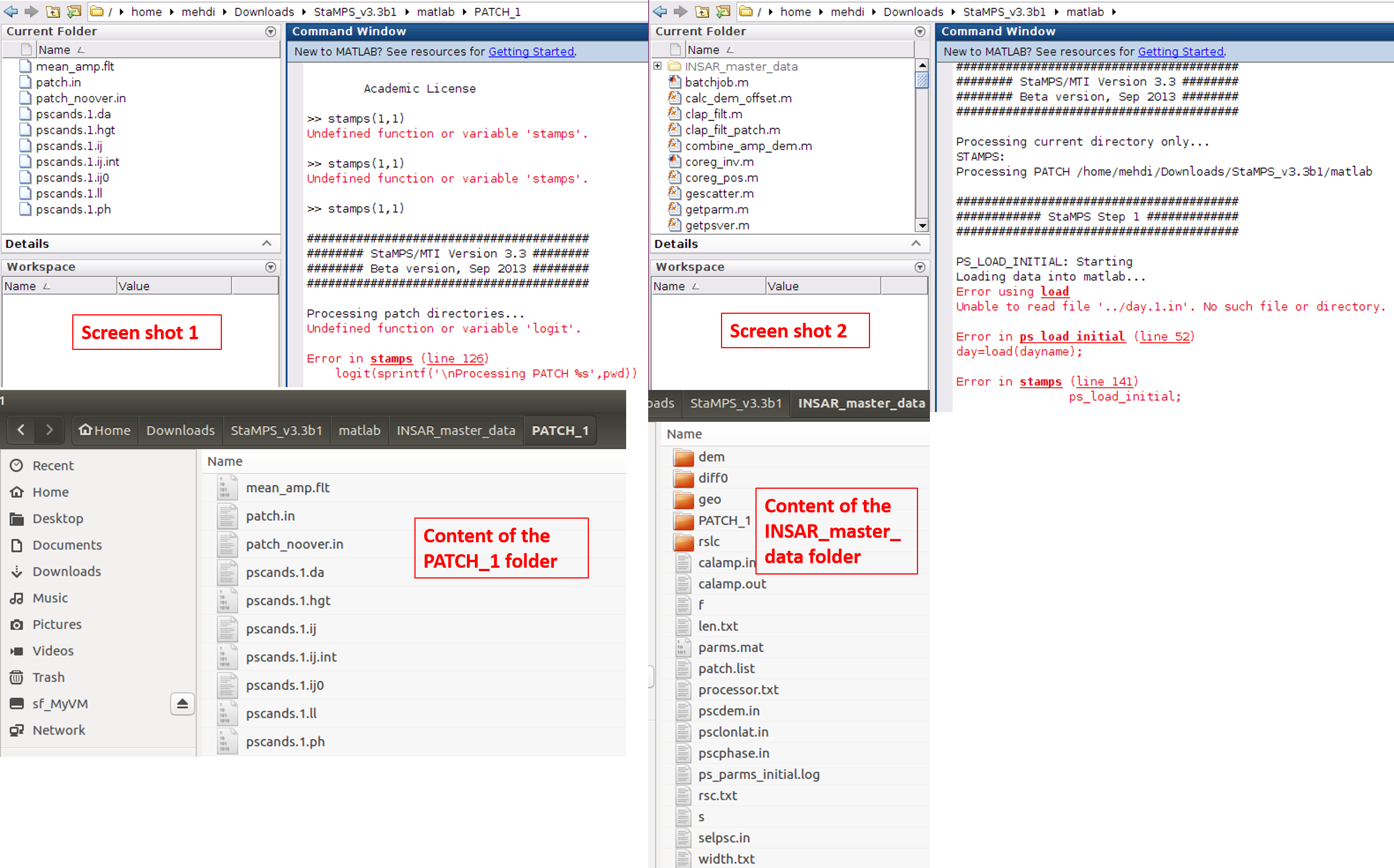
Many thanks for your great efforts on this thread. I followed your guideline and think I could export successfully my data for importing to the STAMPS. I attached the log of mt_prep_gamma_snap(changed). But when I run Matlab in the ‘‘INSAR_master_data’’ directory, which dem/rslc/diff0/geo/PATCH_1 located, Matlab is loaded with ‘‘INSAR_master_data’’ directory but when I type stamps(1,1), I get massage ‘‘undefined function or variable stamps’’ !!?
Since Matlab codes of stamps are not in the current directory, it is normal to get such error massage. I do not know whether matlab should have already integrated with stamps during the stamps installation or not?
Nevertheless, I manually transferred my PATCH_1 folder to the matlab folder of stamps and ran stapms (1,1), I got error massage of the screen shot 1. When I manually transferred the whole ‘‘INSAR_master_data’’ folder to the matlab folder of stamps and ran stapms (1,1), I got the error massage of the screen shot 2 (the same as ABraun’ problem). Thanks for any hint. I use SNAP6&pr5/Linux (Ubunu)/Matlab 2015b
Log (mt_prep_gamma_snapchanged).txt (7.0 KB)
maybe addpath(directory of matlab folder in your Stamps installation) is needed in order to be able to call Stamps scripts when you are in the INSAR_masterdate directory
Dear all
I ran into a running problem when executing Stamps step6
As shown in the picture
How to solve this problem?
Thank you
Dino
Hi Katherine,
Thanks so much for posting your work flow above, I’ve found it incredibly useful, and following it I’ve been able to successfully run stamps on Sentinel 1.
I was wondering if you ever got an answer to your question regarding the lat and lon files exported from preview 5? I’ve used preview 5 to export sentinel 1 stacks to stamps following your recipe (but skipping TC) and then successfully run stamps. However, despite having the correctly named master_date.lat and master_date.lon files in the geo directory, the results from stamps are still not geocoded. Any ideas?
All the best, and thanks again,
tdb
Hi tdb,
Mostlikely you have a mistake but it is difficult to find where your problem is - the information is very poor.
Katherine
did you rename them master_date .lat/lon or did you insert the date of your master? For example, 20160515.lat/lon?
You should do the latter and be precise about the date formatting.
Hi Andreas,
I actually didn’t rename them - I added latitude and longitude bands to subset_master_Stack_Deb using band math as Katherine mentioned above, and then snap export to stamps automatically put the following files into the geo directory:
20170818.lat
20170818.lat.par
20170818.lon
20170818.lon.par
elevation_dem.rdc
elevation_dem.rdc.par
where 20170818 is the date of the master image in YYYMMDD. This all using snap 6 preview 5.
Thanks for your help!
sorry for the misunderstanding, I thought the names were not correct.
Dear kleok,
You are right. My problem solved. Thank you
Hi everybody,
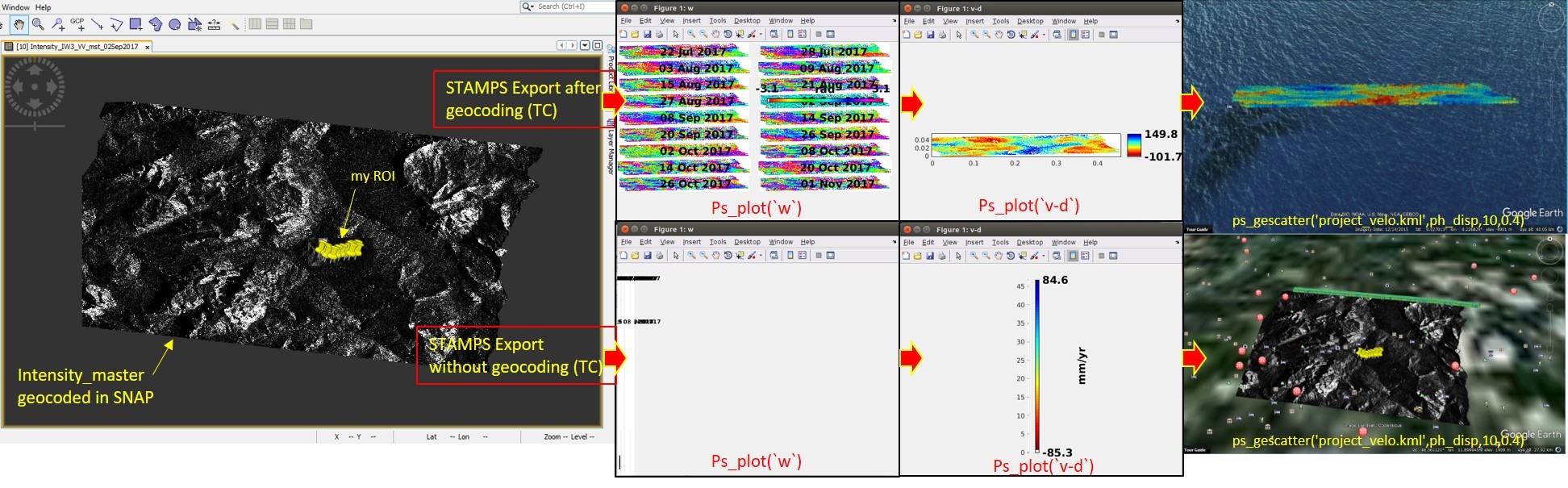
I managed to process 18 S-1 data using STAMPS but I encountered some problems and difficulties and I hope you can guide me. I used the mentioned guideline in this topic and exported STAMPS files using SNAP6.pr5 in two different ways : 1- with TC and 2- without TC (as you can see on the attached file).
When I did not use geocoded data in ‘‘STAMPS export’’ step, the wrap ifgs look wired but when I processed the data using the geocoded data (with TC) by STAMPS, at least I could have some results (of course I am not still sure regarding its correctness). After generating the kml file of ps, the ps pixels velocity located in the middle of the ocean (in ‘‘with TC’’ approach) and positioned at the top of my data as a line-like shape (in ‘‘without TC’’ approach)!!
It would be appreciated if anyone could help me.
Regards,
Mehdi
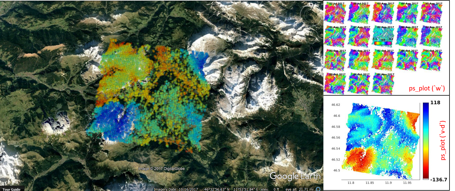
Dear all,
As you can see in my previous post I had the problem regarding the proper position of my PS pixels. I found the new version of SNAP by chance and in its Remove Topo tool has been added an ''oethorectified lat/long option (i.e. in the parameter section) as @mfitrzyk already mentioned. So, we do not need to geocode the needed files for STAMPS exporting anymore. My problem was solved by using the new version of SNAP (see below photo). I thought it worth sharing to save the time. Merry Christmas and happy New Year.
Hi Mehdi,
i am facing the same problem as you had,
using SNAP 6 and latlong is very different untitled.fig (1.6 MB)
Could you explain how did you solve ur problem?
I am using SNAP6, mt_prep_gamma
If it is now possible to skip Terrain Correction, how do I add Lat and Lon bands to the product?
Yes I figured it out eventually, thanks!