Hi, I’m new to the forum, and I also recently started using SNAP, version 9.0.0, besides I don’t know English well, so forgive me if my writing is confusing.
I’m trying to proceed to make a Terrain Correction in an image from Sentinel 1, but I always get the same error problem.
Before reaching this point, I previously proceeded to perform the following steps:
Subset
Apply Orbit File
S-1 Thermal Noise Removal
S-1 Remove GRID Border Noise
Calibration
Single Product Speckle Filter
So far so good, but when I proceed with the following instruction:
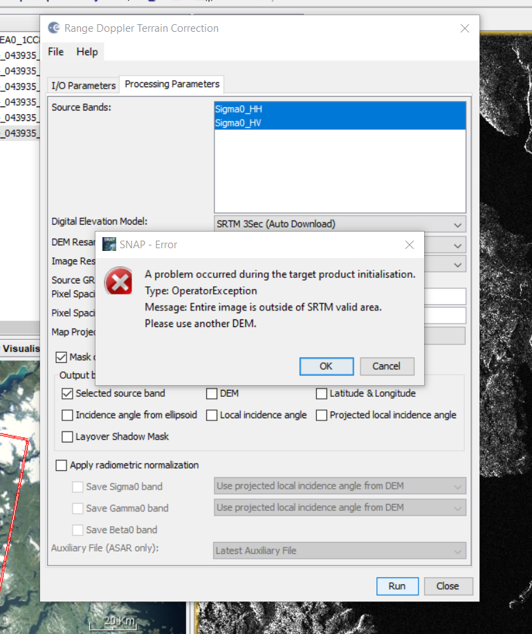
Range-Dopper Terrain Correction
The following error message appears: A problem occurred during the target product initialisation. Type OperatorException. Message: Entire image is outside of SRTM valid area. Please use another DEM.
Thank you for responding so quickly.
I already understood, my image is out of range of SRTM, it is located on the Baffin Island in Nunavut, Canada, lat = ( 66°00’- 65°30’) N, and long (65°00’- 66°00’) W approximately.
So, how can I proceed to make the terrain correction whit SNAP?, or be able to georeference it, since the image presents the inverted poles.
I’m learning how to use SNAP completely on my own, and there are a lot of things I don’t know that I have to learn as I go along. Until just two months ago I didn’t even know SNAP existed, so it’s all new to me.
I’m going to read the documentation you suggest to see how I can create my own DEM in that region.
Thanks for the help I received with my previous problem with SNAP, happily I managed to solve it.
Now I have a new problem but related to Copernicus, so I don’t know if you can help me, but anyway I’m going to expose my problem.
I’m trying to download Sentinel 1 images taken in October 2021, but I get a warning that says the following: “Offline product retrieval has been initiated. Please check again your Cart to know when it will be online.”
I waited a while for the images to be available and then this other warning comes up: “The retrieval of offline data is temporary unavailable, please try again later.”
Does this mean that the images are unrecoverable? How can that be possible?
Thanks