Hello, when I try to download DEM data using “Add Elevation Band” option (SRTM 1sec GRID)
the elevation band is empty.
Please see the attached file

See: SRTM zip files are corrupted or not found
It appears that NASADEM, Release of NASADEM has made SRTM obsolete.
1 Like
Thanks for the quick reply.
Finally, I managed to download SRTM 1Sec HGT, deactivating the antivirus.
But, I have another question about the Slope product. Is that possible to create a new percentage slope band from the elevation SRTM 1Sec HGT band?
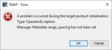
Moreover, I tried to estimated it from the menu: Raster - DEM Tools, but I get an error message.
Please see the attached image.

The error message indicates missing metadata
did you convert the data to another format?
I imported the tiff image and converted to dim format. Afterwards the elevation and land cover bands have been added.
and where is the tif file from?
Maybe you can shortly outline all steps you undertook so we have a chance to identify the point where the issue has its roots.
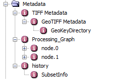
Please find attached a zip file containing two categorical bands (dim format). In this file I would like to add the elevation band ( I already have done that, right click and “Add elevation band”) and the slope band ( I get en error message). IMAGE.zip (221.1 KB)
Regards
It seems likely that the missing metadata was lost in creating the geotiffs. Any dim files created from the geotiffs will not have the required metadata elements. Please describe how the geotiffs were created.
1 Like
I agree with @gnwiii
the metadata is no longer present
Maybe you can share with us what you want to do with the data and we can recommend a processing order which allows you to include the elevation band without errors.
1 Like
Sorry for the delay reply.
I have two categorical images (2 tiff files). Firstly I would like to import these images to the same file (2 bands) secondly to add the elevation band and finally to add the slope band. So, in order to do the first step I used the Collocation procedure (raster menu) to add the 2 categorical raster data (as Master and slave). Afterwards I added the elevation band, but what about the slope band?
Please find attached the 2 initial tiff categorical images.
indices.zip (257.9 KB)
Thanks for the support.
I wish you Happy New Year.
thank you for sharing the data. I tested it and get the same error.
I also tested other data (e.g. a Landsat product) and the same error occurs. @lveci can you please check if the operator works correctly? It works for radar data, but not for optical or elevation data (no range spacing)