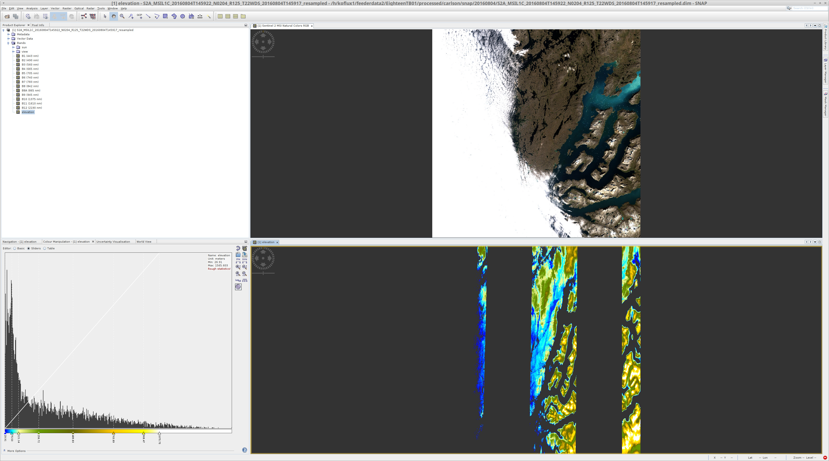
Hello- I want to use S2 IdePix for a fjord region in Greenland that is out of the geographical bounds for the SRTM DEM. I can easily add an elevation band to my product (30 m copernicus).I can’t figure out how to change the DEM in IdePix. How can I do this?
Try to specify the as DEM name “Copernicus 30m Global DEM” instead of “SRTM 3Sec”.
This way the Copernicus DEM should be used.
Thanks. I specified the Copernicus 30m Global DEM, but now I get error in the screenshot.
Do you know what this error means?
Not sure. Maybe you need to resample your data first? Do you have the latest updates installed? Could you post the log file? It is explained at the bottom of the Read This Before Posting section.
This might help to identify the issue.
So, after some tinkering I can get it to work on individual tiles, but I cannot get IdePix to work after I have mosaicked two tiles. I guess I could use IdePix separately and find some way to merge the results, but I would prefer to use it on the mosaic. Is that possible? I have attached the log.messages.log (121.6 KB)
The problem is that your mosaic does not have the same rasters as the original S2 product.
One or more of the following rasters are missing:
“sun_zenith”, “sun_azimuth”, “view_zenith_mean”, “view_azimuth_mean”
If you have a mosaic, I hope it is not too big. That you do mosaic e.g. 5 products at 10m to one. This would probably consume to much memory. S2 IdePix is known not to be fast an especially when enabling cloud shadow detection, it also consumes a lot of memory.
IdePix is intended to be run at the beginning of a processing chain.
Ok, I am ready to give up on applying IdePix to the mosaic. I can apply it to each L1C tile. However, I cannot get the netCDF file format to work on my linux machine. The masks are empty. When I use my mac (personal computer) the nc file output works properly.
Basically, I need to quantify the change in area in the mountain shadows and snow/ice in my (high-latitude) area of interest. The AOI is covered by two tiles, hence the original idea to apply IdePix to the mosaic. IdePix does a very good job of identifying the mountain shadows and snow/ice pixels so I do not want to reinvent the wheel, but I do need a format that I can easily work with the masks in matlab/python (hence my desire to work with .nc files).
I could attempt all the processing on my personal computer but that’s not optimal so I would like to figure out why the Linux computer won’t produce .nc files. The .dim files look fine. I tried exporting the mask pixels but that takes ages. Any ideas?
Looks like I spoke too soon. Now I have some strange problem with the DEM on my linux machine. There seems to be a problem with the DEM coordinates. This happens for both Copernicus global DEM products.
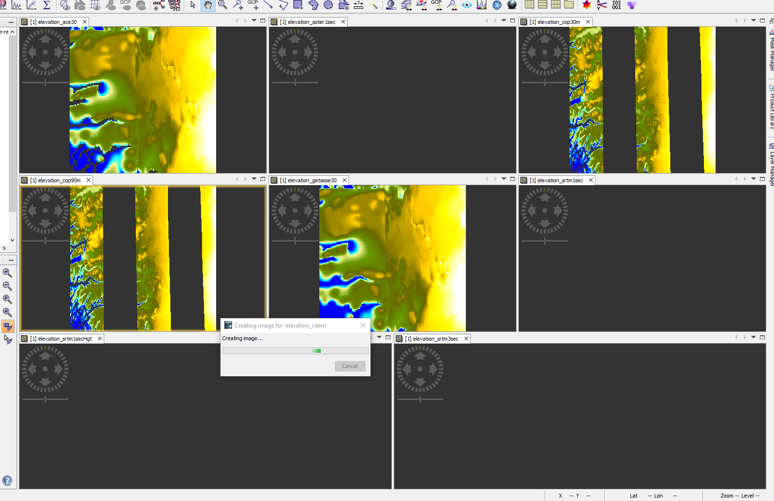
I recently made the same experience in the south of Greenland. Just one tile below yours.
SRTM does not provide any data, also aster_1sec provides no data.
The Copernicus DEMs provides corrupted data.
Only the low-res DEMs lie ACE30 and GETASSE30 provide good data.
And the CDEM didn’t finish to download data.
The different results are shown in the image below.
I don’t know if the missing data of the Copernicus DEM is an issue of the data is itself or if SNAP does not correctly download the data.
@lveci Can you check this?