When using gpt of SNAP version 6.0.0, my Sentinel-1 pre-processing graphs worked as expected. After updating to the newest version of SNAP and Sentinel-1 toolbox, gpt fills the screen with some sort of diagnostic output:
x = 4900.0, y = 2744.0, lat = 63.07686596721361, lon = 29.021174522894118, iter = 1, x’ = 4900.173414230347, y’ = 2744.01251132079
x = 4920.0, y = 2744.0, lat = 63.077857562883075, lon = 29.03271750605734, iter = 1, x’ = 4920.016619682312, y’ = 2744.0134880974847
x = 4940.0, y = 2744.0, lat = 63.07884817322127, lon = 29.04426088598319, iter = 1, x’ = 4940.657133102417, y’ = 2744.0132962306343 …
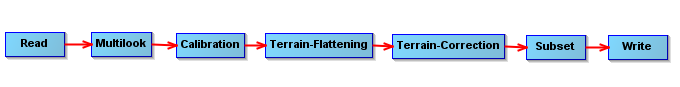
I assume this output comes from operator Terrain-Correction.
Is this output intentional ? If so, is there a way to get rid of this useless (to me) diagnostic output ? In an interactive console, this type of output is no big harm but in a batch processing environment it makes log files practically unreadable.
The diagnostic output indeed disappeared in S1tbx v 6.0.6. Now the problem is that my graph stopped working.
Null point exception, coming maybe from Terrain-Flattening:
…
Image(TerrainFlatteningOp.java:764)
at org.esa.s1tbx.sar.gpf.geometric.TerrainFlatteningOp.computeTileStack(TerrainFlatteningOp.java:483)
… 38 more
Caused by: java.lang.NullPointerException
at org.esa.s1tbx.sar.gpf.geometric.TerrainFlatteningOp.computeIlluminatedArea(TerrainFlatteningOp.java:1313)
at org.esa.s1tbx.sar.gpf.geometric.TerrainFlatteningOp.generateSimulatedImage(TerrainFlatteningOp.java:721)
… 39 more
Error: java.lang.NullPointerException
I tried to regenerate the graph (on my Windows-10 computer) and run it but no success so far with S1tbx version 6.0.7.
The graph (the one that worked yesterday with S1tbx 6.0.5) is: S1mosPreprocessExt20180118.xml (5.6 KB)
The image product was: S1B_IW_GRDH_1SDV_20170902T154015_20170902T154040_007215_00CB7C_BF5F.zip
The DEM file was in the format that at least used to be accepted by SNAP: Plate Carre projection, pixel dimension the same in latitude and longitude, in GeoTiff format.
Ciao
Yrjö
PS. Also multilook before calibration worked with S1tbx 6.0.5.