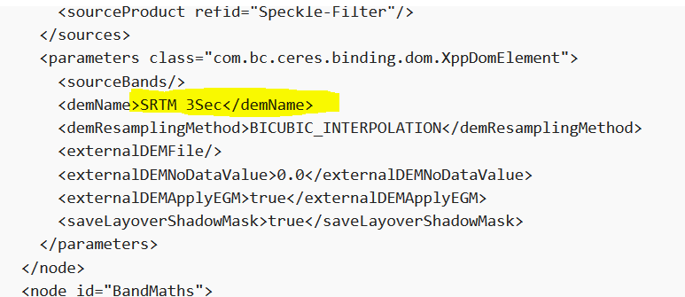
I downloaded Sentinel 1 imagery and processed it with this workflow:
<graph id="Graph">
<version>1.0</version>
<node id="Read">
<operator>Read</operator>
<sources/>
<parameters class="com.bc.ceres.binding.dom.XppDomElement">
<file>inputFile</file>
</parameters>
</node>
<node id="Subset">
<operator>Subset</operator>
<sources>
<sourceProduct refid="Read"/>
</sources>
<parameters class="com.bc.ceres.binding.dom.XppDomElement">
<sourceBands>Amplitude_VH,Intensity_VH,Amplitude_VV,Intensity_VV</sourceBands>
<region>0,0,10710,10004</region>
<geoRegion>POLYGON</geoRegion>
<subSamplingX>1</subSamplingX>
<subSamplingY>1</subSamplingY>
<fullSwath>false</fullSwath>
<tiePointGridNames/>
<copyMetadata>true</copyMetadata>
</parameters>
</node>
<node id="Calibration">
<operator>Calibration</operator>
<sources>
<sourceProduct refid="Subset"/>
</sources>
<parameters class="com.bc.ceres.binding.dom.XppDomElement">
<sourceBands/>
<auxFile>Product Auxiliary File</auxFile>
<externalAuxFile/>
<outputImageInComplex>false</outputImageInComplex>
<outputImageScaleInDb>false</outputImageScaleInDb>
<createGammaBand>false</createGammaBand>
<createBetaBand>false</createBetaBand>
<selectedPolarisations>VH,VV</selectedPolarisations>
<outputSigmaBand>true</outputSigmaBand>
<outputGammaBand>true</outputGammaBand>
<outputBetaBand>true</outputBetaBand>
</parameters>
</node>
<node id="Speckle-Filter">
<operator>Speckle-Filter</operator>
<sources>
<sourceProduct refid="Calibration"/>
</sources>
<parameters class="com.bc.ceres.binding.dom.XppDomElement">
<sourceBands/>
<filter>Lee Sigma</filter>
<filterSizeX>3</filterSizeX>
<filterSizeY>3</filterSizeY>
<dampingFactor>2</dampingFactor>
<estimateENL>true</estimateENL>
<enl>1.0</enl>
<numLooksStr>1</numLooksStr>
<windowSize>7x7</windowSize>
<targetWindowSizeStr>3x3</targetWindowSizeStr>
<sigmaStr>0.9</sigmaStr>
<anSize>50</anSize>
</parameters>
</node>
<node id="Terrain-Correction">
<operator>Terrain-Correction</operator>
<sources>
<sourceProduct refid="SAR-Simulation"/>
</sources>
<parameters class="com.bc.ceres.binding.dom.XppDomElement">
<sourceBands/>
<demName>SRTM 3Sec</demName>
<externalDEMFile/>
<externalDEMNoDataValue>0.0</externalDEMNoDataValue>
<externalDEMApplyEGM>true</externalDEMApplyEGM>
<demResamplingMethod>BILINEAR_INTERPOLATION</demResamplingMethod>
<imgResamplingMethod>BILINEAR_INTERPOLATION</imgResamplingMethod>
<pixelSpacingInMeter>40.0</pixelSpacingInMeter>
<pixelSpacingInDegree>3.593261136478086E-4</pixelSpacingInDegree>
<mapProjection>GEOGCS["WGS84(DD)",
DATUM["WGS84",
SPHEROID["WGS84", 6378137.0, 298.257223563]],
PRIMEM["Greenwich", 0.0],
UNIT["degree", 0.017453292519943295],
AXIS["Geodetic longitude", EAST],
AXIS["Geodetic latitude", NORTH]]</mapProjection>
<alignToStandardGrid>false</alignToStandardGrid>
<standardGridOriginX>0.0</standardGridOriginX>
<standardGridOriginY>0.0</standardGridOriginY>
<nodataValueAtSea>true</nodataValueAtSea>
<saveDEM>false</saveDEM>
<saveLatLon>false</saveLatLon>
<saveIncidenceAngleFromEllipsoid>false</saveIncidenceAngleFromEllipsoid>
<saveLocalIncidenceAngle>false</saveLocalIncidenceAngle>
<saveProjectedLocalIncidenceAngle>false</saveProjectedLocalIncidenceAngle>
<saveSelectedSourceBand>true</saveSelectedSourceBand>
<outputComplex>false</outputComplex>
<applyRadiometricNormalization>false</applyRadiometricNormalization>
<saveSigmaNought>false</saveSigmaNought>
<saveGammaNought>false</saveGammaNought>
<saveBetaNought>false</saveBetaNought>
<incidenceAngleForSigma0>Use projected local incidence angle from DEM</incidenceAngleForSigma0>
<incidenceAngleForGamma0>Use projected local incidence angle from DEM</incidenceAngleForGamma0>
<auxFile>Latest Auxiliary File</auxFile>
<externalAuxFile/>
</parameters>
</node>
<node id="SAR-Simulation">
<operator>SAR-Simulation</operator>
<sources>
<sourceProduct refid="Speckle-Filter"/>
</sources>
<parameters class="com.bc.ceres.binding.dom.XppDomElement">
<sourceBands/>
<demName>SRTM 3Sec</demName>
<demResamplingMethod>BICUBIC_INTERPOLATION</demResamplingMethod>
<externalDEMFile/>
<externalDEMNoDataValue>0.0</externalDEMNoDataValue>
<externalDEMApplyEGM>true</externalDEMApplyEGM>
<saveLayoverShadowMask>true</saveLayoverShadowMask>
</parameters>
</node>
<node id="BandMaths">
<operator>BandMaths</operator>
<sources>
<sourceProduct refid="Terrain-Correction"/>
</sources>
<parameters class="com.bc.ceres.binding.dom.XppDomElement">
<targetBands>
<targetBand>
<name>Sigma0_VH_masked</name>
<type>float32</type>
<expression>if layover_shadow_mask_VH > 0 then 0 else Sigma0_VH</expression>
<description/>
<unit/>
<noDataValue>0</noDataValue>
</targetBand>
</targetBands>
<variables/>
</parameters>
</node>
<node id="Write">
<operator>Write</operator>
<sources>
<sourceProduct refid="BandMaths"/>
</sources>
<parameters class="com.bc.ceres.binding.dom.XppDomElement">
<file>outputFile</file>
<formatName>GeoTIFF</formatName>
</parameters>
</node>
<applicationData id="Presentation">
<Description/>
<node id="Read">
<displayPosition x="37.0" y="134.0"/>
</node>
<node id="Subset">
<displayPosition x="159.0" y="14.0"/>
</node>
<node id="Calibration">
<displayPosition x="206.0" y="164.0"/>
</node>
<node id="Speckle-Filter">
<displayPosition x="149.0" y="229.0"/>
</node>
<node id="Terrain-Correction">
<displayPosition x="370.0" y="318.0"/>
</node>
<node id="SAR-Simulation">
<displayPosition x="179.0" y="280.0"/>
</node>
<node id="BandMaths">
<displayPosition x="487.0" y="240.0"/>
</node>
<node id="Write">
<displayPosition x="455.0" y="135.0"/>
</node>
</applicationData>
</graph>
when I compare the result with the data that I can download from the EO-Browser, I see that my resolution is way worse. See the comparison:
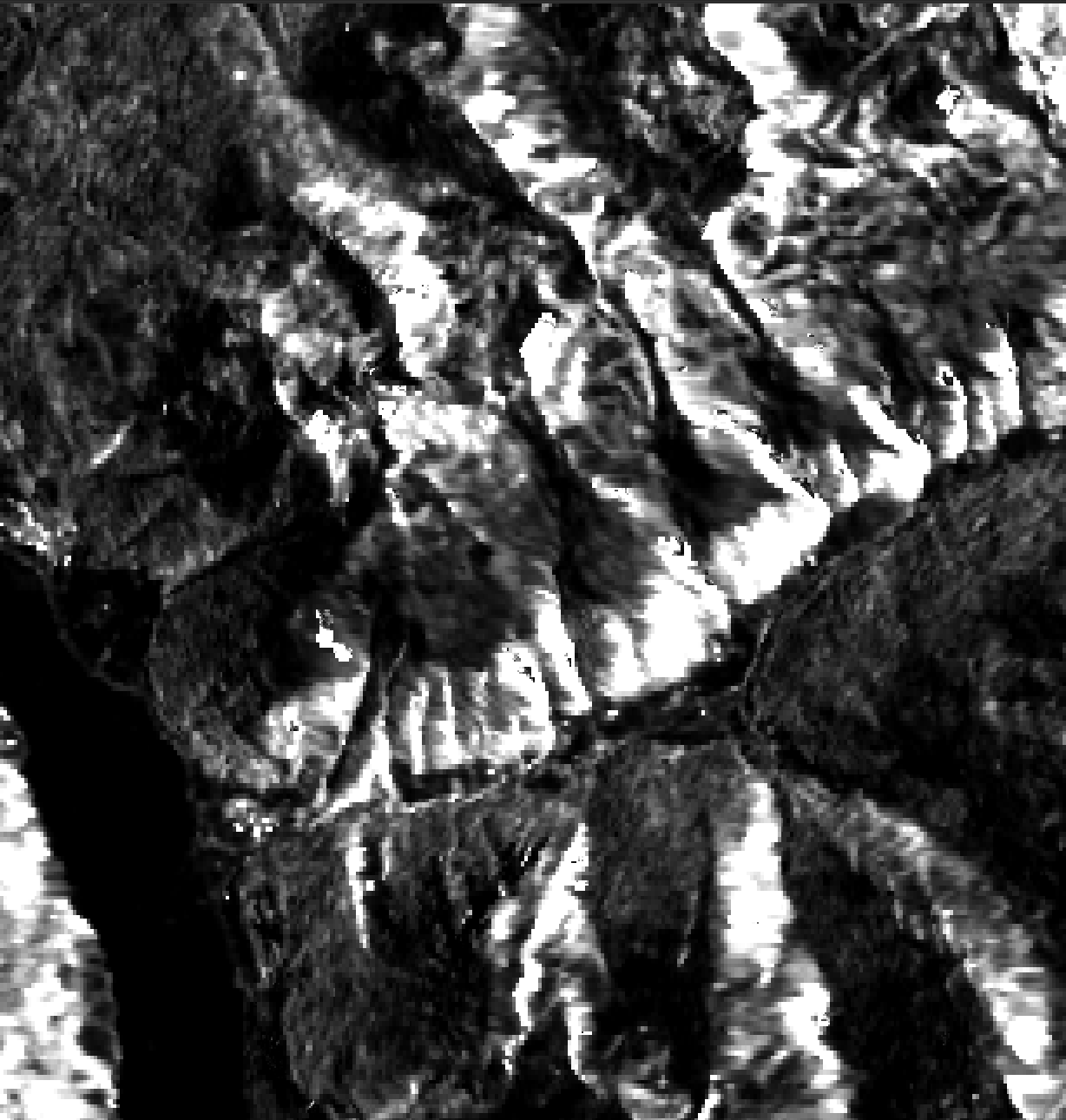

What am I doing wrong?
Thanks!