Would the raw data of radarsat include long wavelengths, and can unprocessed radarsat satellite data be used to identify minerals or underground treasures?
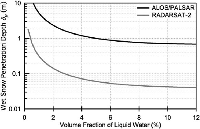
Radarsat is a C-band mission, so the penetration depth is limited.
Take this as an example: Radarsat can penetrate into dry snow up to one meter, but with increasing moisture content, this rapidly decreases to the amount of a few centimeters. And the water content of soils is potentially higher.
L-band missions, such as ALOS are more suitable, but also have their limits.
2 Likes
Thanks for the helpful explanation, how do you opinion I can access the data of such satellites that can penetrate below the surface and what are the conditions, please advise
some L-band data is available via ASF: https://search.asf.alaska.edu/ (select ALOS PALSAR), but I am no expert on subsurface mapping.
Maybe it is good to read some articles on this to get an idea: https://scholar.google.com/scholar?q=subsurface+structures+sar
May I ask how you came to this challenge?
1 Like
First of all, thank you for your help and guidance. Well, in previous questions that went unanswered, I researched what kind of satellites have this capability and can solve the problem I am facing, so the only thing that came to my mind was that Let me see if this is possible. But I have heard that this can be done with the help of satellite, but I have not reached that stage and I need more guidance, which you have been kind to me in this way,
I hope the post is not irrelevant to the topic, please if it is irrelevant and against the law of the page so I can delete it
it’s not irrelevant, there are no bad questions 
I just don’t have an answer, so let’s wait for some more opinions.
I can recommend this course and the materials: https://eo-college.org/
1 Like
I appreciate you, hope i can find a solution with the help of you and other friends