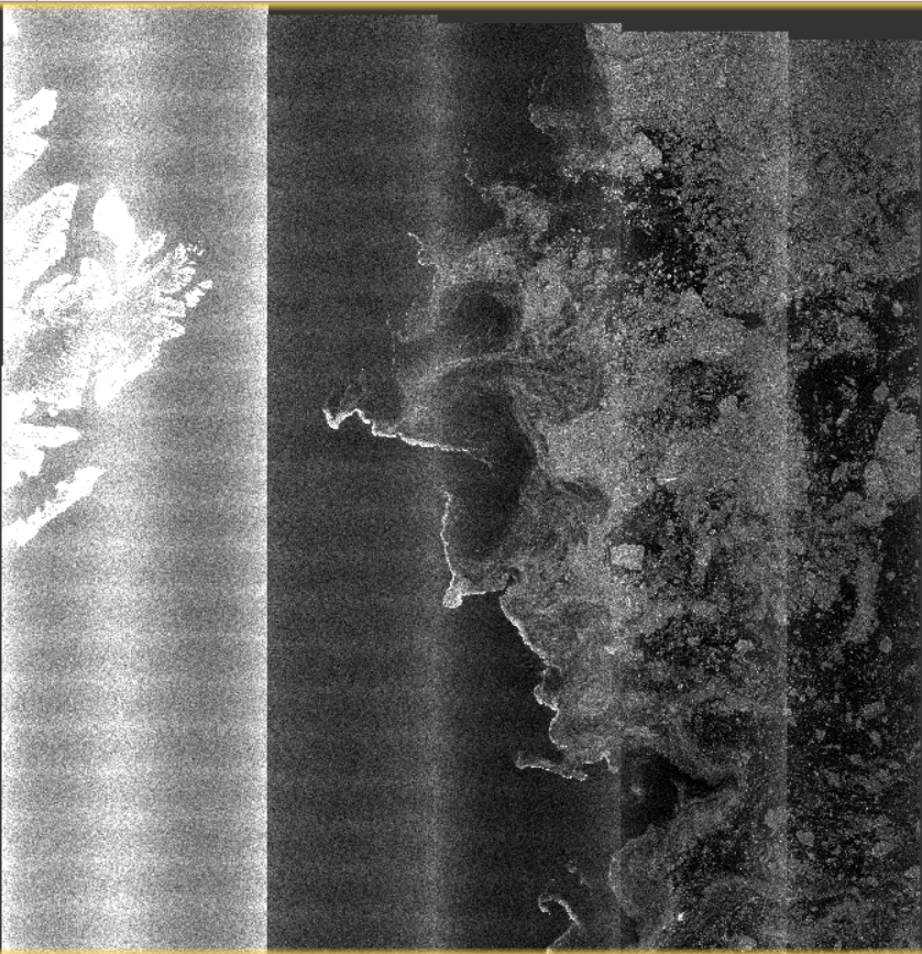
Do you have any recommendations on dealing with the vertical stripes over the ocean?
I saw this ftp://ftp.nersc.no/pub/Anton/Sentinel1A_classification_EGU2015_korosov.pdf which uses average values of images over calm water, but I don’t know how to do it.
I’m studying sea ice so that I need to deal with this problem in calibration.
Thanks
Have you solved the hv vertical stripes over the sea ice zone?
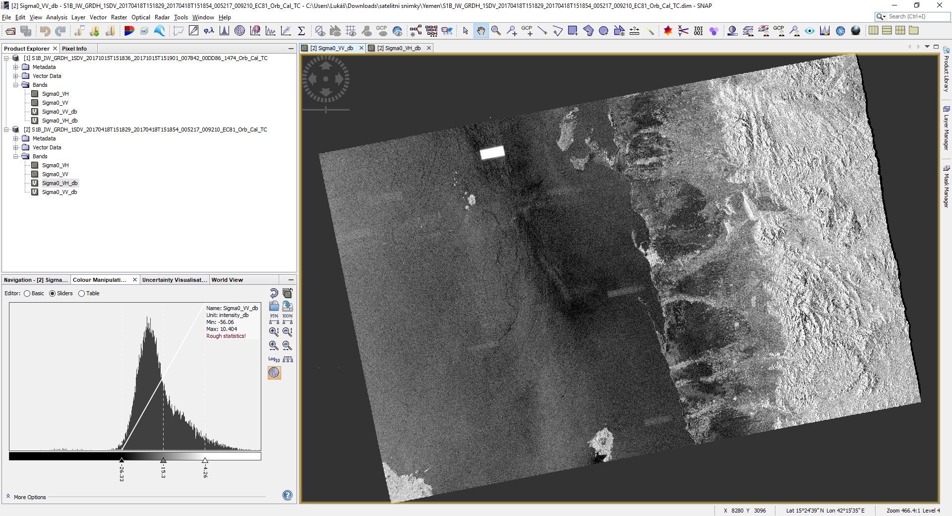
I encounter a question about radiometric calibration. Sentinel-1A data with VV and VH polarization for IW products, the radiometric calibration of VH polarization is right, but the VV polarization is incorrect using the SNAP processing.
I never encountered that. No idea what it is
The rectangular shapes are Radio-Frequency Interference (RFI) from transmitters on the ground.
Is It caused by army objects? This scene is from Yemen - port of Hodeidah. Looking for difference before siege and during the siege…
Further RFI examples can be seen in Sections 4.2.11 and 6.2.9 of the S1 Annual Performance report for 2016 - see Radiometric calibration problem.
1 Like
its bit of a long shot , a little convoluted but it will be possible and fun to identify RFI areas using a bit of machine learning - any one got the capacity to do this in real-time for entire S1 catalogue?  https://www.arcgis.com/apps/MapJournal/index.html?appid=dfc6873c8a604daa8912609bf846859d
1 Like
Hi kirill.s. Can you tell me the specific process to solve this problem?
Please give us more information on your product and your data processing and what exactly your problem is about.
This is the name of my product:S1A_EW_GRDM_1SDH_20180719T072036_20180719T072140_022860_027A98_C108.
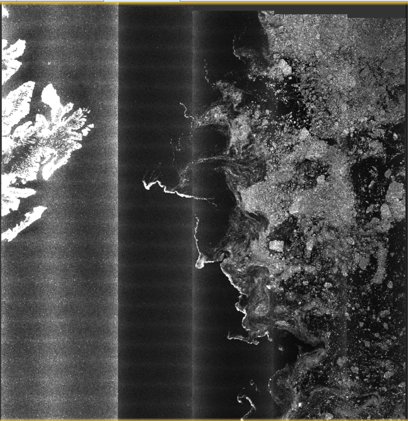
My question is how to effectively remove the vertical stripes, like the kirill.s’ s image. I’ve tried this method: thermal noise removal->speckle filtering->radiometric calibration. But it didn’t work out so well.
There are results.Can you help me with this problem, please?
I think this comment describes your only options. EW data has its downsides.
1 Like
Ok, thank you. I do use the ocean and sea ice data. But I once read a paper on the removal of thermal noise with good results based on EV data. Whether on the ocean or on land.
Thank you again, I will continue to explore this issue.
I don’t think it is a valid answer #abraun
Since I have read 2 papers on thermal noise removal and texture corrections of noise from Sentinel-1 EW mode images over ocean itself.
Mentioned by *Park et al.
So if it’s worked for them I think TNR works over ocean too (if applied correctly)
I just want to know if the latest snap (8.0 version) is able to remove TNR over sea.
I have tried myself and failed performing an apt one several times.
Also, as mentioned by @iveci it does create extra noise over sea.
So, is it appropriate to just ignore this noise?
Is it recommended?
Of course different methods are being developed to correct such patterns, but only standard TNR and Calibration are implemented in SNAP so far.
The article you mentioned is not based on SNAP, they developed their own processing. I do not understand much of it, but if you do you can try to implement it yourself.
1 Like
It’s also worth keeping in mind that many papers floating around are… let’s call them optimistic when it comes to the generality of their results.
1 Like
Thanks for that.
But how is it possible that the Sentinel products are not being corrected by their own software SNAP? Little curious. Sentinel products being publicised for their availability free of cost data and customer support, I expected I would find a way out here in the forum. But a little upset that it didn’t work that way.
Have you solved this by the way?
Am at this point a year later and still have the same issue
Copernicus Sentinels data is offered with a specific sensor performance that has been defined, implemented and verified. The S1-MPC (Mission Performance Centre) routinely monitors, assesses the quality of the data against the mission requirements.
SNAP itself is offered free of charge by ESA (outside of the Copernicus programme) to facilitate the scientific exploitation, however contrary to what you state or believe. SNAP is not “an own software” of the Copernicus Sentinels or the Copernicus programme. SNAP is composed of a number of operators and algorithms that are carried over (from legacy toolboxes) and adapted to different missions, it can happen that certain errors occur and need fixing. BTW, SNAP is open source software and the source code is fully available…
Copernicus Sentinel data is freely available and you can freely contact the official support.
This forum is for SNAP, an Open Source Software that streamlines the scientific exploitation of EO data from a number of EO missions. It is not an official channel of the Copernicus Programme. Like any other open source software it relies on the community to improve it. Which may means that everyone can provide bug fixes, feature suggestions or new algorithms/operators for SNAP to help improve the software and thus contribute to the overall community.
In any case the SNAP community is nevertheless composed of very knowledgeable people, coming from different profiles so you may still obtain an answer to your questions. You just need to manage expectations.
1 Like