Sentinel 1

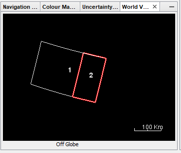
i have a problem with the extents of my sentinel 1 image, actually as shown in the image above, am selecting the frame 1 to download from ESA, when i process the snap tool to calibrate i only get the frame 2 and my area is not totaly covered.

Type of the product :S1B_IW_SLC__1SDV
PNG
can anyone please help me with this, am new to radar imagery.

thanks in advance.

what tools did you use to process the data?

It actually looks like you selected only one sub-swath for processing. But calibration does not do that.
https://sentinel.esa.int/web/sentinel/user-guides/sentinel-1-sar/acquisition-modes/interferometric-wide-swath

I used snap as a tool and yes i choose only one sub-swath for processing thank you for your help .

I would like to use change detection with sentinel 1 and SNAP , there is any tutorial that i can use ?

Many thanks

So that answers your question?

Here is a tutorial on flood mapping with Sentinel-1 data and SNAP: https://www.youtube.com/watch?v=derOXkPCH80

Yes it answers my question thank you very much