I downloaded L2P_GHRSST-SST skin SLSTRA from EUMETSAT and imported it in SNAP. The data has spatial projection, however, when I export it as a geotiff format and open in GIS software, all the angles and distances are distorted and the image acts as if it was lacking geo-referencing. I tried re-projecting in both SNAP and GIS software but without success. When I tried to run Geometric correction (either SAR- Simulation Terrain Correction or Range-Doppler Terrain Correction or Simulate a SRA image) the error I receive is ‘Metadata radar_frequency has not been set’.
Does someone know what this error mean and how to get about the main task: EXPORT GHRSST SKIN Temperature as a geotiff that will be correctly spatially located and referenced? 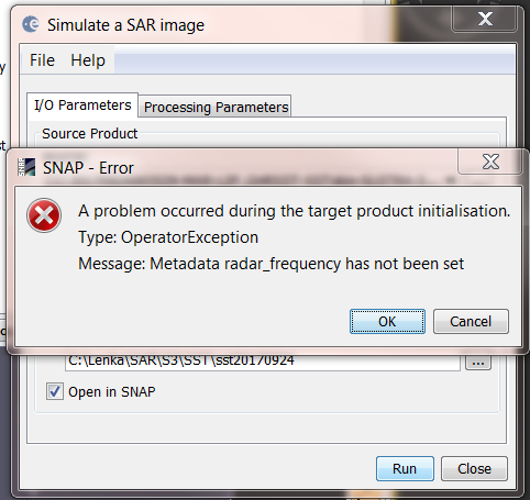
The display of the data should be OK after you have reprojected it.
Don’t use the SAR tools for SLSTR. Use the Reprojection you find in Raster / Geometric Operations / Reprojection.
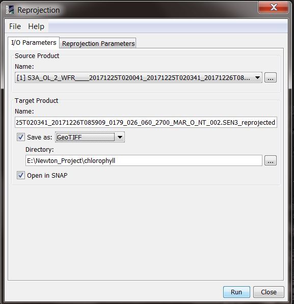
Thanks a lot for a reply. If I reproject Raster/Geometric Operations/Reprojection and export it as a tiff I get an error that the file is too big. If I use GeoTiff-Big , the process is running throughout the whole night (spatial extent- Philippines) and it never stops so I had to stop it manually. Then the output shows nan values. At the moment, I am exporting is as NetCDF to see whether it works (currently working with S3A_OL_2_WFR____20171128T020041_20171128T020341_20171129T091205_0179_025_060_2700_MAR_O_NT_002.SEN3 though)
What causes the problem of exporting it as a tiff/geotiff, please?
How much memory do you have in your PC? Could be that it is not enough.
I must have enough memory as my RAM is 16GB. When I reproject Sentinel-3 (SA3_OL_2_WFR CHL OC4ME) it does the very same thing. It is running for 24hours and then when I see the reprojected saved image has not changed the size for some time, I decide to abort the process manually. The reprojected image is completely black. Could you please advise me what am I doing wrong?
The amount of data is very big after reprojection. That’s also the reason why you can’t use GeoTiff.
GeoTiff can only save data up to 2GB. If the file gets bigger the BigGeoTiff format must be used.
When reprojecting the product also all tie-point grids are expanded to be full-sized bands.
I would suggest that you carefully select the data nodes you really need. Maybe you don’t need all the FWHM, solar_flux, lambda0 bands and also not the atmospheric_temperature_profile tie-point grids.
If you write to NetCDF, you should consider using NetCDF4. Thi will ensure that the data is compressed and does not occupy to much space on disk.
Hi Marco,
Lenka and I discussed the problems she was having via email. For reference, attached is a little tutorial I wrote to help some training participants with SNAP GEOTIFF export. Feel free to use/share if needed!
Best wishes to you both,
Hayley
Data conversion and export in SNAP.pdf (49.3 KB)
3 Likes
Wow, that’s great 
Looks good. I’ll review it more closely and we might make it available in our tutorial section.
Thanks a lot, to both of you.
Finally…
Your guide is now available on the tutorials page.
Thanks again @hek17 and @lenkafronkova
2 Likes
I found this document really helpful, thank you. The routine also works with the Graph Builder.
1 Like