Hello,
I’m coming with an external Terrain correction problem which seems to propagate in the following graph with GPT. I’m testing simple graph before going further.
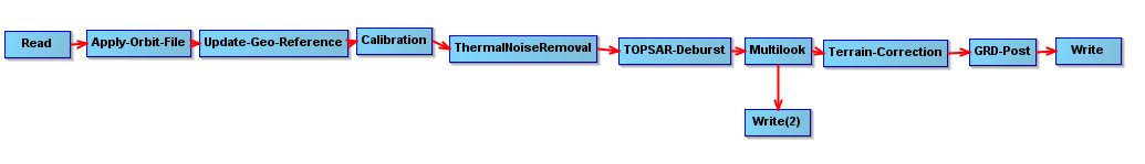
Command : C:/Program Files/snap/bin/gpt C:/…/SLC_to_GRD_orbit_Cal_Thermal_Multi_TC_MNSLidar.xml -e -c 93350M -q 8 -PinFile=C:/…/S1A_IW_SLC__1SDV_20150821T055817_20150821T055844_007357_00A1B9_4D44.zip -PoutFile=C:/…/S1A_IW_SLC__1SDV_20150821T055817_20150821T055844_007357_00A1B9_4D4_TC
When processing data with SRTM 1s (auto download), GPT seems to do its job. When going with an external DTM (1m resolution), I get the error pasted bellow.
My config (on server):SNAP 2.0.1 + s1tbx 2.0.2 ( 128 Go RAM, no HDD memory limit ).
The GC overhead limit indicate a memory problem but GPT works with more than 50 Go RAM free besides it. Furthermore, it takes hours to go for the processing (before failure) using such DTM at 1m (while it takes 70 minutes with SRTM). Any option to reduce computation time with high resolution?
Thank you for any answer !
Full error message :
TOPSAR-Deburst: Cannot construct DataBuffer.
Multilook: java.lang.NullPointerException
Multilook: java.lang.NullPointerException
TOPSAR-Deburst: java.lang.NullPointerException
Multilook: java.lang.NullPointerException
Multilook: java.lang.NullPointerException
Multilook: java.lang.NullPointerException
TOPSAR-Deburst: GC overhead limit exceeded
Multilook: java.lang.NullPointerException
Multilook: java.lang.NullPointerException
Multilook: java.lang.NullPointerException
Multilook: Cannot construct DataBuffer.
TOPSAR-Deburst: Cannot construct DataBuffer.
Multilook: Cannot construct DataBuffer.
Multilook: java.lang.NullPointerException
Terrain-Correction: GC overhead limit exceeded
Terrain-Correction: Terrain-Correction: GC overhead limit exceeded
org.esa.snap.core.gpf.OperatorException: TOPSAR-Deburst: Cannot construct DataBuffer.
- at org.esa.snap.core.gpf.graph.GraphProcessor$GPFImagingListener.errorOccurred(GraphProcessor.java:373)*
- at com.sun.media.jai.util.SunTileScheduler.sendExceptionToListener(SunTileScheduler.java:1646)*
- at com.sun.media.jai.util.SunTileScheduler.scheduleTile(SunTileScheduler.java:921)*
- at javax.media.jai.OpImage.getTile(OpImage.java:1129)*
- at javax.media.jai.PlanarImage.cobbleFloat(PlanarImage.java:3254)*
- at javax.media.jai.PlanarImage.getData(PlanarImage.java:2181)*
- at com.bc.ceres.glevel.MultiLevelImage.getData(MultiLevelImage.java:64)*
- at org.esa.snap.core.gpf.internal.OperatorContext.getSourceTile(OperatorContext.java:420)*
- at org.esa.snap.core.gpf.internal.OperatorContext.getSourceTile(OperatorContext.java:406)*
- at org.esa.snap.core.gpf.Operator.getSourceTile(Operator.java:442)*
- at org.esa.s1tbx.sar.gpf.MultilookOp.computeTile(MultilookOp.java:180)*
- at org.esa.snap.core.gpf.internal.OperatorImage.computeRect(OperatorImage.java:80)*
- at javax.media.jai.SourcelessOpImage.computeTile(SourcelessOpImage.java:137)*
- at com.sun.media.jai.util.SunTileScheduler.scheduleTile(SunTileScheduler.java:904)*
- at javax.media.jai.OpImage.getTile(OpImage.java:1129)*
- at javax.media.jai.PlanarImage.cobbleFloat(PlanarImage.java:3254)*
- at javax.media.jai.PlanarImage.getData(PlanarImage.java:2181)*
- at com.bc.ceres.glevel.MultiLevelImage.getData(MultiLevelImage.java:64)*
- at org.esa.snap.core.gpf.internal.OperatorContext.getSourceTile(OperatorContext.java:420)*
- at org.esa.snap.core.gpf.internal.OperatorContext.getSourceTile(OperatorContext.java:406)*
- at org.esa.snap.core.gpf.Operator.getSourceTile(Operator.java:442)*
- at org.esa.s1tbx.sar.gpf.geometric.RangeDopplerGeocodingOp.computeTileStack(RangeDopplerGeocodingOp.java:911)*
- at org.esa.snap.core.gpf.internal.OperatorImageTileStack.computeRect(OperatorImageTileStack.java:116)*
- at org.esa.snap.core.gpf.internal.OperatorImageTileStack.computeTile(OperatorImageTileStack.java:85)*
- at com.sun.media.jai.util.SunTileScheduler.scheduleTile(SunTileScheduler.java:904)*
- at javax.media.jai.OpImage.getTile(OpImage.java:1129)*
- at javax.media.jai.PlanarImage.getData(PlanarImage.java:2085)*
- at com.bc.ceres.glevel.MultiLevelImage.getData(MultiLevelImage.java:64)*
- at org.esa.snap.core.gpf.internal.OperatorContext.getSourceTile(OperatorContext.java:420)*
- at org.esa.snap.core.gpf.internal.OperatorContext.getSourceTile(OperatorContext.java:406)*
- at org.esa.snap.core.gpf.internal.OperatorImage.computeRect(OperatorImage.java:73)*
- at javax.media.jai.SourcelessOpImage.computeTile(SourcelessOpImage.java:137)*
- at com.sun.media.jai.util.SunTileScheduler.scheduleTile(SunTileScheduler.java:904)*
- at javax.media.jai.OpImage.getTile(OpImage.java:1129)*
- at com.sun.media.jai.util.RequestJob.compute(SunTileScheduler.java:247)*
- at com.sun.media.jai.util.WorkerThread.run(SunTileScheduler.java:468)*
Caused by: org.esa.snap.core.gpf.OperatorException: TOPSAR-Deburst: Cannot construct DataBuffer. - at org.esa.snap.engine_utilities.gpf.OperatorUtils.catchOperatorException(OperatorUtils.java:386)*
- at org.esa.s1tbx.sentinel1.gpf.TOPSARDeburstOp.computeTileStack(TOPSARDeburstOp.java:798)*
- at org.esa.snap.core.gpf.internal.OperatorImageTileStack.computeRect(OperatorImageTileStack.java:116)*
- at org.esa.snap.core.gpf.internal.OperatorImageTileStack.computeTile(OperatorImageTileStack.java:85)*
- at com.sun.media.jai.util.SunTileScheduler.scheduleTile(SunTileScheduler.java:904)*
- … 33 more*
Error: TOPSAR-Deburst: Cannot construct DataBuffer.
TOPSAR-Deburst: GC overhead limit exceeded
Multilook: TOPSAR-Deburst: GC overhead limit exceeded