Workflow between SNAP and StaMPS

Dear @bayzidul, @ABraun, @FeiLiu, @annamaria, @katherine…,

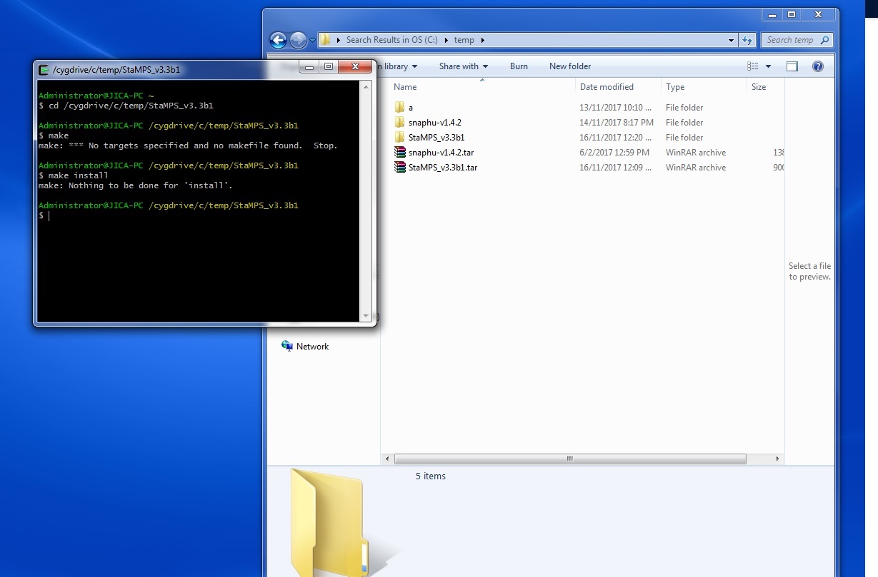
I have successfully get PSI result from StaMPS with 70 sentinel-1 images by using SNAP 6.0 PREVIEW4.

Now, I’m trying to process with SNAP 6.0 PREVIEW5 and met some problems.

I found that in PREVIEW5, we couldn’t put the products with Terrain Correction (stack_deb_TC and stack_deb_ifg_dinsar_TC) in stamps export. It would have error like this:

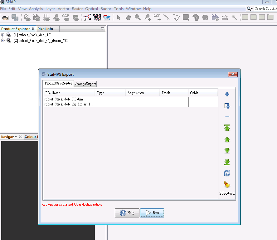
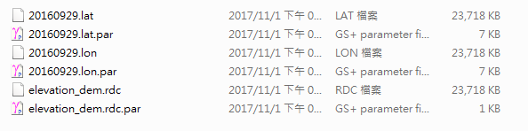
So, I just put “stack_deb” and “stack_deb_ifg_dinsar” for stamps export. After this step, we could directly get master_date.lon and master_date.lat in the geo folder.

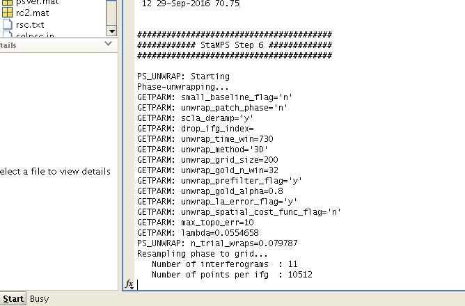
And then processed in StaMPS, it took very long time (over one day) in step 6 so far. It didn’t fail, still running now, but I think it’s not a normal condition for just 12 images.

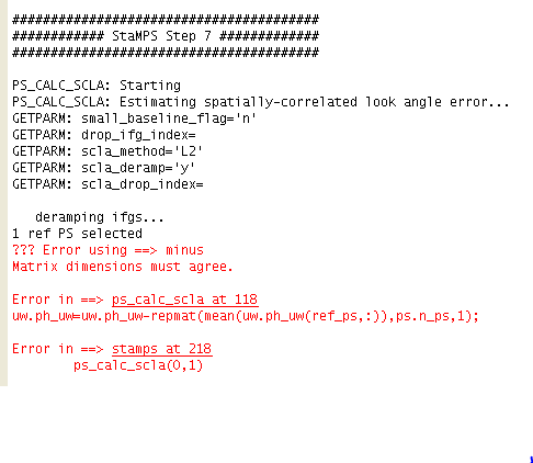
I also have tried to replace the master_date.lon and master_date.lat files generated by stamps export automatically by the method we got these files before. But it failed in StaMPS step7.

Have anyone test to process with SNAP 6.0 PREVIEW5?

I have same problem, too.
Dose anybody know what cause this problem?

dear @sharon, no sorry.
i used only preview4. I think that it is importan report the issue (about TC export) to developers in this topic. Issues/Observations/Comments of SNAP 6.0 Beta :wink:

Thank you for your reply !!

Hello,

I’m having the same problem (error when adding the terrain corrected stacks to the STAMPS export tool). Do you know if it is still possible to download SNAP 6 preview 4? I can only find preview 5 on the download page.

Hi @tdb. I don’t know.
You might ask for in this topic.
http://forum.step.esa.int/t/issues-observations-comments-of-snap-6-0-beta/6722?u=annamaria

The link to download preview 4
http://step.esa.int/downloads/6.0-pre4/

3 Likes

The problem with PS point visible on water is related to the lon/lat export, which is currently not fully correct.
We are working on it

Hi @mfitrzyk .
What does it mean not fully correct? There are shift problems with lat/lon band export or coregistration problems? please, let me know.

@annamaria @cwong is currently investigating it but it seems that the lat/lon band is not correctly exported in Stamps export. There are some artifacts/blanks in the lon/lat band
We are working to fix it as soon as possible

@katherine you are performing TC before exportting to Stamps. Isn’t it that you need to export in radar coordinates and add this lon/lat bands to process in Stamps ?

@mfitrzyk, I use same workflow of @katherine.
It would not be necessary to use TC before Stamps export, but using Snap’s products without TC, there are shift problems in StaMPS and pixels seem warped.

is currently investigating it but it seems that the lat/lon band is not correctly exported in Stamps export.

Sorry, i don’t undestand where is the problem. Lat/lon bands are exported in binary file (in my case, in gamma file) with File->Export->Sar formats -> Gamma, so it is indipendent by StaMPS export tool.

Ok. The Stamps export is also doing it - saving lon/lat - so you dont need to save it separately.
I would need to look how @katherine is doing it to be able to say something more

Sorry for the trouble @mfitrzyk.
I used Snap, versions 5 and 6 - preview4 (under unix-ubuntu), but these versions do not export the bands lat/lon. Are you using a new preview?

Dear Magdalena,
Normal procedure is to export to StaMPS SNAP products in radar coordinates and then export to gamma or ENVI format lon/lat bands of the master (Deb). But without TC as Annamaia has already written the PS location is warped.
Katherine

1 Like

Dear Magdalena,
I also tried to save lon/lat using the Stamps export but lon/lat bands were not exported. So I saved them separately.
Katherine

1 Like

Dear Abraun

I followed your tutorial about how to unwrapped phase using snaphu deal with cygwin, and it is successful, thank you.
however, how to use StaMPS in cygwin.

Thank you

jef

here the attached file

Please have a look here:

1 Like

At which step you are exporting these two bands? Lon/lat shall be orthocorrected but in SAR geometry.
The lon\lat export was added in preview 5 but there were some problems with exported bands. This is currently being fixed.

1 Like