Hello all! Help me find the problem, please.
I work with latest version SNAP (3.0.3). The operational system in my computer is Debian Linux 8 (Jessie). The Sentinel-1 images are:
S1A_IW_SLC__1SDV_20160109T035542_20160109T035609_009412_00DA26_1176
and
S1A_IW_SLC__1SDV_20160414T035543_20160414T035610_010812_0102B5_66E3
I work with uncompressed (un-ZIP) data.
I try make the displacement map. But I can not make normal unwrapped phase. I do the following steps (by the tutorial ). I doublicate ALL options from this tutorial.
Open uncompressed data (two Sentinel-1A’s images)
Coregistration data (Radar > Coregistration > S1 TOPS Coregistration > S1 TOPS Coregistration). For coregistration I choose of IW2 subswatch, 5-6 burst and VV polarisation for both Sentinel’s images. It is area of southern part of Kryvyi Rih’s iron ore basin (Ukraine).
Phase Filtering (Radar > Interferometric > Filtering > Goldstein Phase Filtering)
After these steps I try to unwrap phase:
Unwrapping (Radar > Interferometric > Unwrapping > Snaphu Export). I export my filtered phase to SNAPHU and processed data with SNAPHU in command-line interface.
Snaphu Import (Radar > Interferometric > Unwrapping > Snaphu Import). I read wrapped phase from layer of my project. The unfrapped phase I read from SNAPHU files.
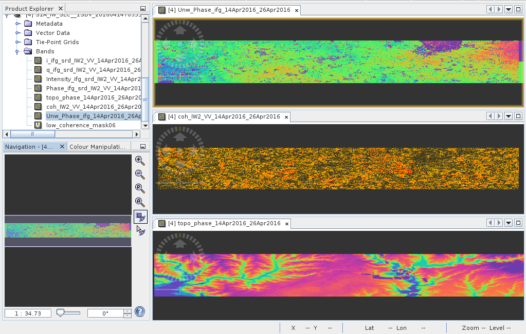
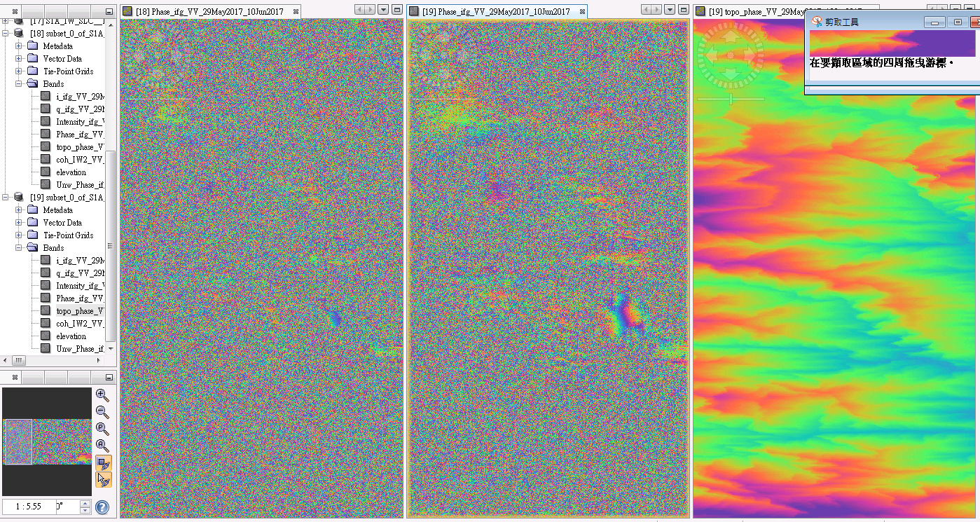
But after all these steps I get stack with flate-Earth unwrapped phase. The wrap-phase, topo-phase and unwrap-phase from finished stack are imaged in screenshot.
Where is a problem? Why I get a flat-Earth unwrapped phase?
Hi dear geka
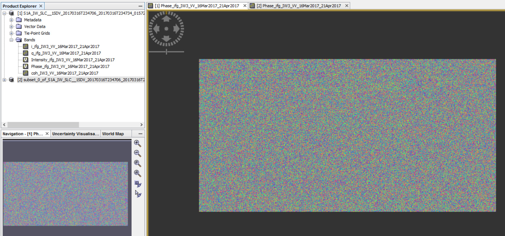
your interferogram image shows that it has low coherence.
In case of low coherence interferogram there are some things to be considered:
1- The time interval between images should be shortened(using time series may result better product)
2- filter window size is important
3- subset your interferogram then use snaphu with no tiling (tile number=0)
I hope your problem will be solved
I am waiting for your results
Dear javadadabi. Thank you very much!
I took Sentinel’s images from 14th April and 26th April 2016. And I replied all my previous steps. I get normal-vision unwrapped phase after all calculations!
Could you tell me more detailed about how you solved this problem?
I got similar unwrapping result, and I have tried what @javadadabi said. I changed the window size smaller and bigger, and also subset a small area for snaphu export. But I couldn’t set the tile number = 0, it appeared error message about the tile number should be positive when running snaphu. After many tests, I still obtain a flat-Earth unwrapped phase.
Please help me to deal with this problem!
Many thanks!
Hi
your right.
In fact when you want to use snaphu with no tilling (to avoid phase jumping), the parameters should be set for numbers of rows and number of columns to one. fortunately in this version of snap(5) you can set parameters using snaphu export command user interface.
but to solve your problem please load a snapshot if possible.
The unwrapping result seems the same as before.
And when I set the FFT size bigger, I could get much clear interferometry info in mountain area. But seems less effect of changing the windows size. So, is it right to set the FFT size to 256 for filtering?
Detailed of the mountain area is as below (I want to get the surface deformation of creeping landslides). The left one set FFT size as 64 and the middle one set FFT size as 256.
Hi
1-It seems that your study area has very low coherence maybe due to Rangeland, grassland or agriculture.
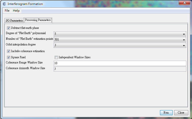
2-be sure to subtract flat earth phase during interferogram formation.
3-in low coherence regions tiled unwrapping has some problems, so subset image to a lower size(for example 4000*2000 pixles) then use snaphu export with row and column of 1.
4- for example the lower right corner of your study area has the best coherence, to be sure that your problem is coherence or not just subset that area and follow steps for it.
5- if the above recommendations did not work, Describe the steps you have taken.
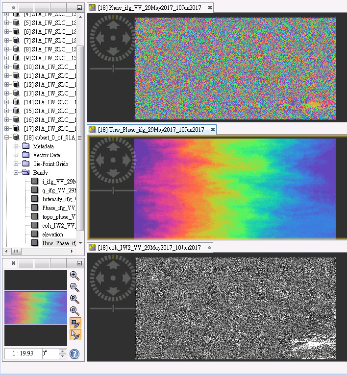
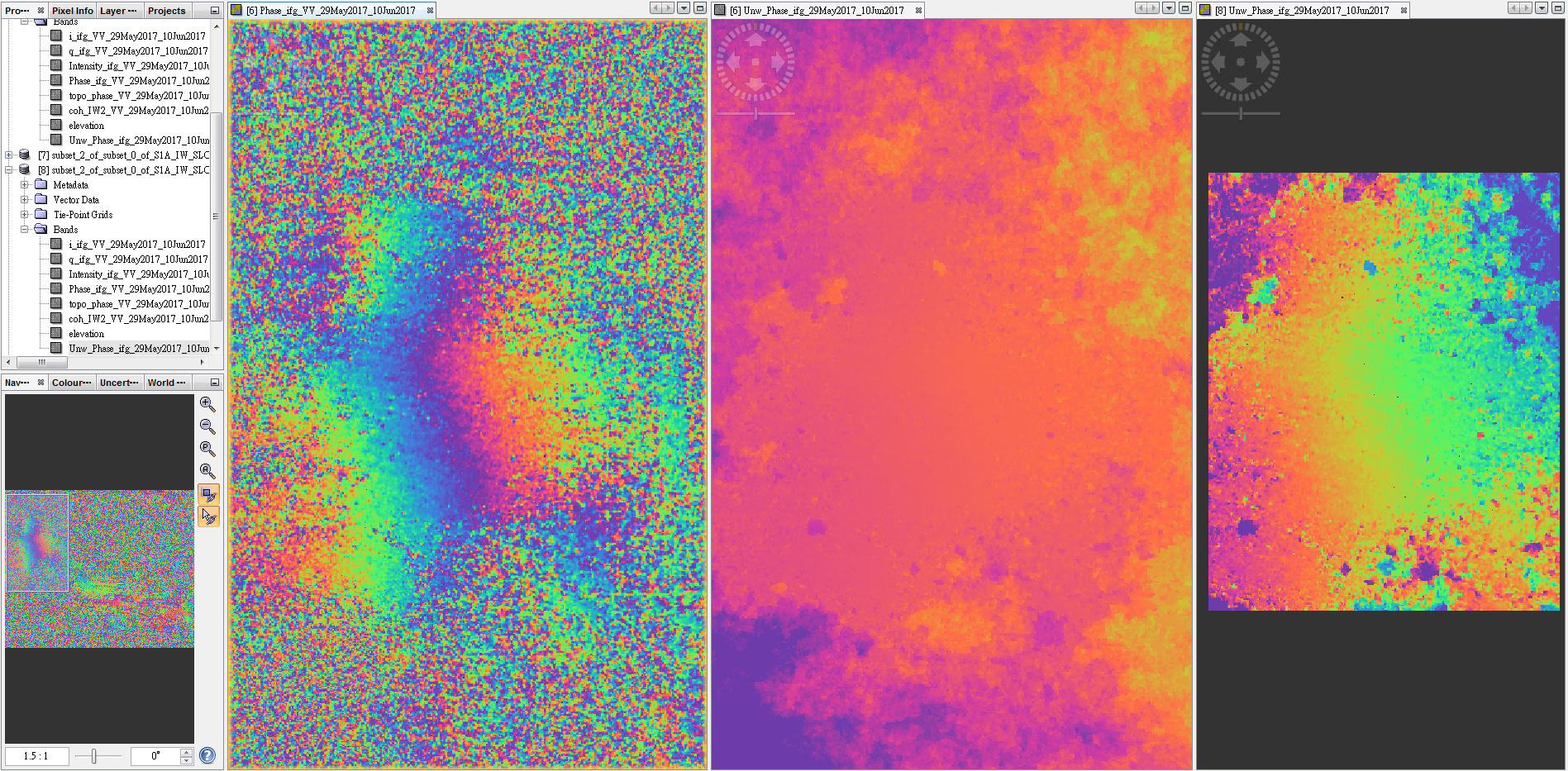
I subset a small area (10121218 pixels) and a very small area (285356 pixels) where have interferometry information in mountain area. I’m not sure if it is too small for phase unwrapping? But if I subset a larger area, there will be more low coherence area which could influence the unwrapping results?
The result is as below (interferogram, unwrapping of small area and unwrapping of very small area)
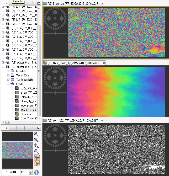
The following one is the result of lower right corner where you have mentioned before, it seems that the unwrapping is correct? But why we got some deformation signal in the upper left rectangle where have low coherence? Or it is unreliable?
From the results above, it seems that the unwrapping error I asked is affected by low coherence. So, it would be difficult to unwrap the interferograms from mountain area directly, right?
Hi
I guess your study area vegetation cover is of type of forest or thick grass. If it is true, it is not possible to calculate creeping landslide using dinsar. the mentioned tutorial presented in the first post by @geka is about dinsar.
As you mentioned you should use Persistent scatter method (psinsar) which is provided in snap menu as radar>>interferometric>>psi/sbase >>stamps export.
just please inform me if my guess about vegetation cover is true or false.
Sorry for late reply.
Yes, my study area seems covered by forest, where is Cingjing Fram in Taiwan.
I will try PSInSAR method for creeping landslide.
Thank you for all your assistance!