Alos2 terrain correction issues

Hello, I can properly correct with range doppler ALOS2 1.1 FBD SM2 but no layover shadow mask is produced with this procedure. I am in high mountain range so I definitively need it.
When I try SAR simulation TC I obtain a mask, but both the bands and the masks are shifted of about 170 m with respect to roads, features etc. and also with respect to the range doppler corrected image (which is ok). I always use SRTM 1sec, projecting in UTM32N the results.
I also tried TC with many different DEMs but the result is the same, except the when errors show up (empty GGP list) or bands are zero value. Not very clear why errors sometimes appear.
What can I do to obtain both a well geolocated image and a layover shadow mask?
thanks a lot Gaia

can you please post some sceenshots for illustraion?

Hello, here below some example.

  1. The first image is a cut exported in Google Earth from the image corrected with SAR sim TC, wgs84 utm32N, nearest neighbour as resampling method, SRTM 1sec, the GCP window is left unchanged except for the uncheck of ‘GCP on land box’, as when is checked errors occur. As you can see there is a geograhic shift (about 170m). I tried several attempts to change parameters in GCP window with errors as output (black bands and error messages). I also tried different DEMs: no crashes but same geographic shift. My idea is that the error is in the GCP window but I do not know how to fix

  1. The second is the same corrected with Range Doppler: same parameters for DEM, resampling and UTM. I found that if I perform range doppler after SAR simulation I can obtain the layover and shadow mask, but I am not happy as this does not give any explanation. Why the simulation with the DEM works in RD and not in TC?
  2. Finally, do you think I have to perform radiometric normalization (checking the box)? I am working with gamma0, I noticed differences with or without radimometric norm. but I do not know what should be done.

Thanks a lot for your support. Gaia

ps: Does PolSARpro new version supports ALOS2 correction?

It strongly depends on the local topography, on the resolution of the digital eleavtion model, and the resolution of the radar data how well the SAR Simulation terrain correction works. In this method, a radar image is simulated based on the radiometric distortions which are caused by the changes in the local incidence angle between the pixels. If SRTM cannot reproduce the patterns which are also observed in the ALOS-2 image (for example because its resolution is 10 times higher), the SAR Simulation Terrain Correction will produce incaccurate results.

Can you first run SAR Simulation to get the layover and shadow mask and then terrain correct these with Range Doppler TC?

Yes this is what I wrote above, I did SAR sim and then range doppler to obtain the mask, and it works. But I am afraid that the procedure is less accurate than the SAR sim TC. Please note I tried also a very accurate DEM (10m) but the shift is unchanged, and also using different DEMs the shift remains (it should change according to DEM used, no?). It is a bit strange.
However, SAR sim and then Range Doppler is a way around to obtain the mask.
Please, can you suggest

  • if I have to apply radiometric normalization in the Range Doppler step (I am working with gamma0)? I observed limited differences in gamma0 values but not sure which is better.
  • I also avoided multilooking as written in the tutorial, is that ok?
    Thanks!!

Sorry, I’m not quite clear on this - how can it be less accurate than RD when the shifts are so obvious?
But I would have also expected different quality using a higher resolution DEM.

Actually, calibration to Gamma0 might be the problem here, because it reduces radiometric distortions in the image, exactly these you need for a proper SAR-Simulation coregistration.

Please try SAR Simulation TC once with Sigma0.

OK I am doing now this attempt, results in few minutes

Please, what about radiometric normalization option in the procedure? I check it or leave uncheck it?
thanks

Hello, here the results: the error persists.
immagine
immagine
The images are linked and the shift is there.

At this point I will use the workaround found before, with SAR sim and then range doppler.

Just would really like to receive your opinion with respect to selecting or not the option of radiometric normalization on gamma0 images in range doppler.
Thanks
Gaia

leave it unchecked, it has no value for calibrated data (we discussed this here)

I also noticed that the geolocation quality of ALOS-2 product strongly varies, mostly because of the orbit information. Where did you get the data from and in which product level?
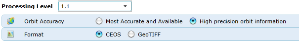
I noticed Level-1.1 provided by JAXA can be ordered with “high precision” orbit or “most accurate and available” which soulds quite similar, but I asked them and only the first one grants that they process the orbit information upon your request before delivery. It takes a bit longer but the geolocation is higher.

grafik

Hi,
If I am not wrong I ordered from jaxa (as PI) the high precision data, and in the summary file from CEOS this seems correct (Pds_ProductID=“FBDR1.1__A”
Pds_OrbitDataPrecision=“Precision”). I will double check.

However this does not clear the issue: if orbit data are not good an imprecise geolocation should occur also with range doppler correction… My feeling is the sw itself has some problem with TC of ALOS2, but unfortunately there are not many other freely available choices.

Thanks for the radiometric normalization suggestion, after reading the discussion at the link now I have it clearer.

cheers

1 Like

I have processed many ALOS-2 datasets, and based on my experience about 10% do not have very precise geolocation. Sometimes RD Terrain Correction worked better (on flat terrain), while in other cases SAR Simulation was better.