Elevation for c2rcc.olci

Greetings,

I am processing OLCI scenes for inland lakes using c2rcc that are above sea-level.

When I include in my xml file as a parameter, gpt does not recognize it.

Is elevation not implemented for c2rcc.olci? If not, is there any way to account for non-sea level impacts on the atmospheric modeling?

Danke schon!
Tim

The elevation is not included as a parameter in the gpt, but the pressure is. Would the pressure be a good indicator for your case?

Hi Ana,

Yes, pressure could work.

I’ll experiment with some scenes (from the Great Lakes).

Many thanks!
Tim

Hi Ana,
I now encounter a problem, hoping to get your answer.

I also tried to use another method, you can see this post, C2RCC for Sentinel 3 OLCI in pytthon - s3tbx - STEP Forum (esa.int)in python. At first I only print variables such as rrs _ 1 found to be 0 or null, but I print out all variables, found that not all are null, but the variables related to reflectivity are null. Does this mean that there is a problem with my method ? But python and cmd methods have problems, what should I do ?
Thanks so much.
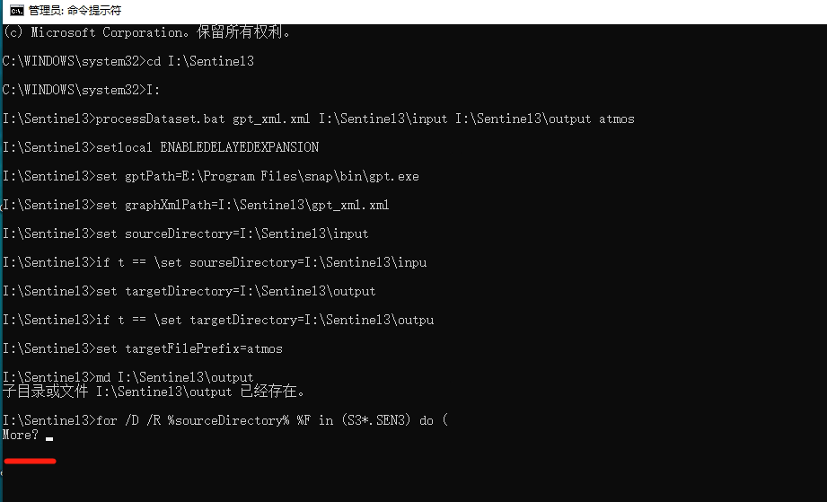
Let’s start form the beginning: have you run an image using the GUI and results look ok? If so, how many images you have to process? How do you intend to use gpt? Command line? I see a .bat fike in your screenshot but it is not used in the right way. I am sorry but I am not able to understand what you are doing and the error you obtained.

https://senbox.atlassian.net/wiki/spaces/SNAP/pages/70503475/Bulk+Processing+with+GPT

Dear Ana,
Thanks a lot.


I am trying to run bulk processing for OLCI, but I have some trouble. Both them didn’t work, there is no data.

Please, try with the SNAP GUI first. Select one image and run it with the Graph Builder and the Batch Processing tools. That will help to understand the .xml file a bit better. After that, try the same process using the command line with only one image. The next step is to run the process on several images. If you have some Python background, I could help to do the batch processing with a Python script later on.

Dear Ana,
Thank you for your reply.
I want to invert the chla of clean lake. I first clipped ROI in batches to reduce the workload, and then do C2RCC. However, I use the following code to get rhown and rrs but so many 0, I think it is a parameter setting problem, I use the default parameters, how to modify the parameters in python? Like in SNAP (shown below)? Whether SNAP can do batch C2RCC?

import os
import time
import datetime
from subprocess import call
filepath1=‘H:/Data/’ #Original data downloaded from website
outputdir=‘H:/C2RCC/’ #C2RCC atmospheric corrected data
filelist1=os.listdir(filepath1)
inputlist=[]
outputlist=[]
for fl1 in filelist1:
outfile1=outputdir+fl1+‘_C2RCC.nc’
if os.path.exists(outfile1):
continue
else:
outputlist.append(outfile1)
filepath2=filepath1+fl1
filelist2=os.listdir(filepath2)
filepath3=filepath2+‘/’+filelist2[0]
filelist3=os.listdir(filepath3)
for fl3 in filelist3:
fl3l=fl3.split(‘.’)
if fl3l[-1]==‘xml’:
filepath4=filepath3+‘/’+fl3
inputlist.append(filepath4)
else:
continue
for inputfile,outputfile in zip(inputlist,outputlist):
try:
print(‘Start processing-----------’+str(datetime.datetime.now()))
print(inputfile)
cmdline=‘gpt c2rcc.olci -SsourceProduct=“’+inputfile+‘” -PoutputAsRrs=“true” -t “’+outputfile+‘” -f “NetCDF4-BEAM”’
call(cmdline)
print(‘End of processing-----------’+str(datetime.datetime.now()))
print(‘\n\n’)
except:
print(inputfile+‘Processing failed’)
continue

And another question, after C2RCC, how do I get a point of rhown to establish Chla model?
69d9fc9d5c0c15981bff8b604c253cc
Because rhown is also two-dimensional, latitude and longitude are also two-dimensional.

Thanks so much.