Regardless of the investigated time (e.g. 4 months), the result is given in mm/year, so you can compare it, but this assumes that the movement observed is constant over the entire year.
Therefore, it is better to distribute all images over a longer time span, so you can identify eventual changes in the deformation rate.
2 Likes
Use several years to get long term phenomenon, otherwise you could see only seasonal effect for a year and not trends in deformation
1 Like
Dear Abraun,
Thank you very much for your reply, as always. I will incorporate it into my future studies.
Best regards
Dear mdelgado,
Thank you very much for your reply. I will consider at least two years in my next PSI or SBAS studies.
Best regards

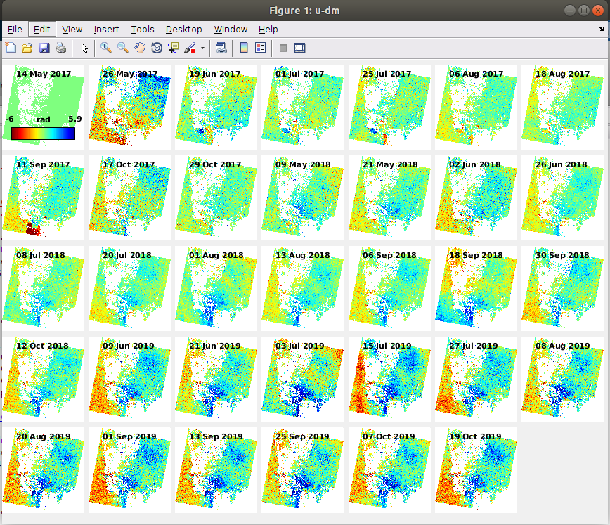
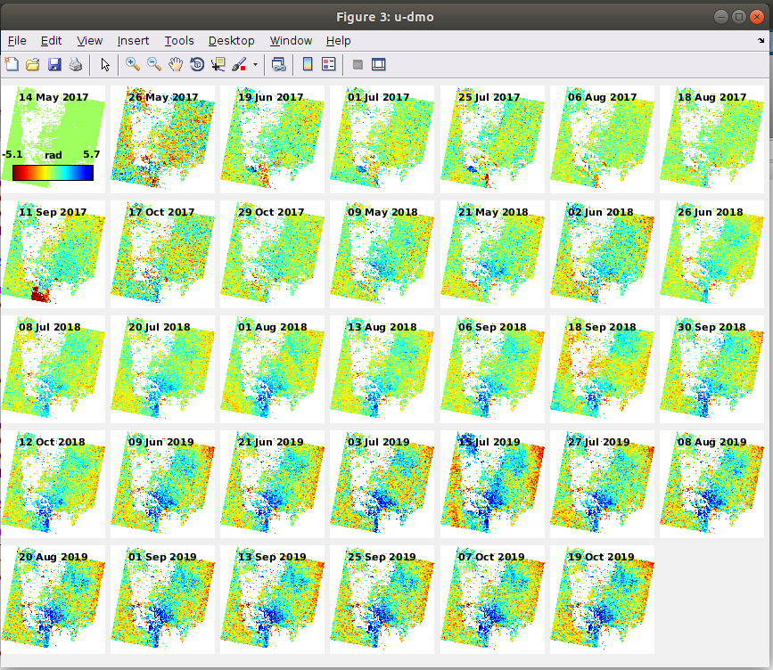
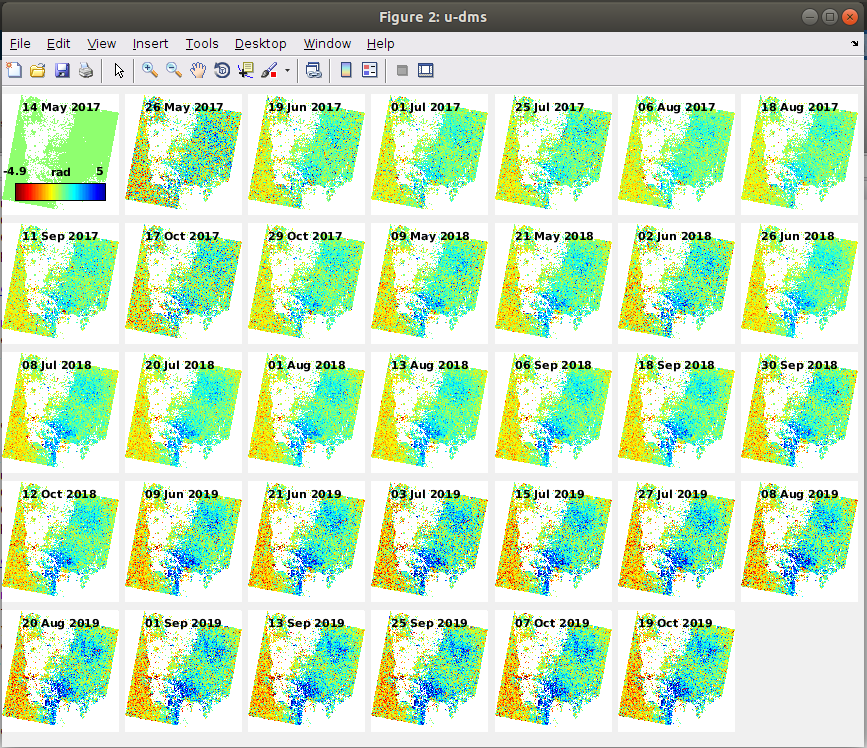
Hello, I am trying to export results into Windows to be able to plot the data using acsii files in another software which is very handy, 3DField. When I type ps_output in matlab, it gives only ps_u-dm data for each interferogram in ascii file. But, instead, I would like to get ps_u-dms data in ascii file for each ifg since this seem to give me more smoothed and hence presumably more accurate results.
Could anyone help me how to generate u-dms output in ascii file?
I assume all ps_u-dm and ps_u-dms or even ps_u-dmo files generate displacement results for each point in mm. Am I understanding this correctly?
Any help here would be greatly appreciated!
PS: Screenshots from matlab of ps_plot(‘u-dm’), ps_plot(‘u-dms’) and ps_plot(‘u-dmo’) are provided below for comparison of the results.
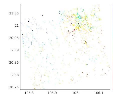
The study area is an oilfield with subsidence. Empty area in the center is a trace of river and in the south-east is a trace of sandy desert. Persistent blue areas are where the cluster of production wells, in the center and in the north-east. Persistent red area in the west - I have no idea, this zone is outside the area of oilfield.
hello every one am waiting your help
since am facing a problem running stamp(2,2)
error in ps parms default (line 94)
error in getparm line 14
error stamps line 53
Hello,
Thanks for the topic, its help me alot. But i have some problem with the result, it seem to be moved long distance to the east.
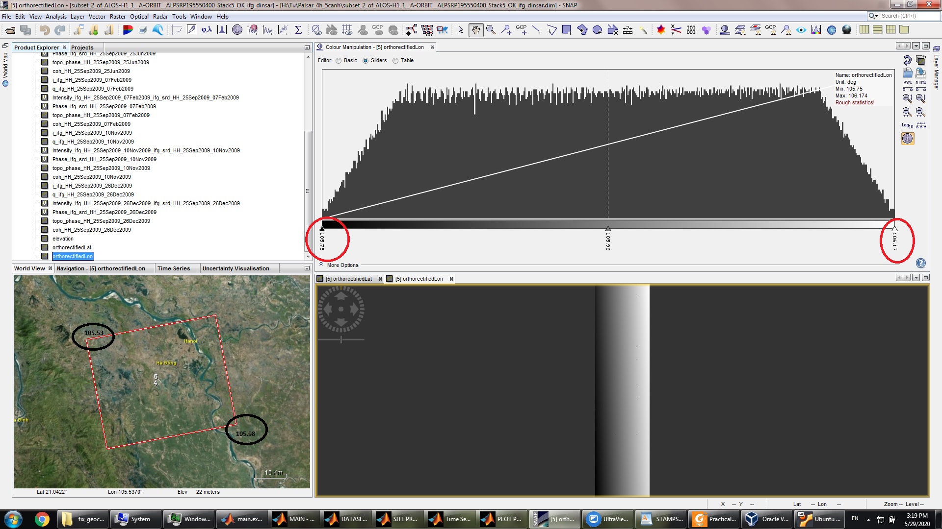
I checked the dataset and found that something wrong with the orthorectifiedLon!
The dataset has the min-lat: 105.55 deg and max-lat: 105.98
But the orthorectifiedLon band has the min-lat:105.75 and the max-lat: 106.17
Help me, please!

how did you export the results to Google Earth?
1 Like
Dear ABraun,
Here is the command:
ps_plot(‘v-d’,-1)
data = load(‘ps_plot_v-d.mat’);
velo = data.ph_disp;
ps = load(‘ps2.mat’)
lonlat = ps.lonlat;
output = [lonlat, velo];
ps_gescatter(‘tubenh2.kml’,data.ph_disp, 10,0.9)
OR
ps_plot(‘v-d’,-1);
data = load (‘ps_plot_v-d.mat’);
velocities = data.ph_disp;
ps = load (‘ps2.mat’);
lonlat = ps.lonlat;
output = [lonlat, velocities];
dlmwrite(‘LOS_velocities.txt’,output)
dlmwrite(‘LOS_velocities_.csv’,output)
dlmwrite(‘LOS_velocities_.csv’,output,‘precision’,‘%.4f’);
i found problem with the coordinate when i look at the result of the command: ps = load (‘ps2.mat’).
have you tried as suggested in the manual?
ps_plot('v-do', -1)
load ps_plot_v-do ph_disp
ps_gescatter('project_velo.kml', ph_disp, 10, 0.4)
1 Like
Dear ABraun,
this command show that something wrong with the coordinate. i have to go check the previous step. and i think the problem come from the lat/long config file. i already checked the dem and the geo folder, they seemed tobe ok.
The Longitude must be about 105.55 to 105.98.
Okay. I have no explation then, sorry.
1 Like
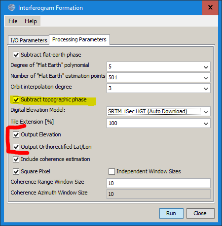
i found something strange after step: topophase removal, the band of orthorectifiedLon was created, can you tell me how to correct this band ?
this is created as a side product of this step. You can entirely skip TopoPhaseRemoval by checking this box in the interferogram generation.
The others are required in the StaMPS exports as well
1 Like
Can you guide me? how to export to stamps without the orthorectified Lat/Lon?
actually, these are required for the StaMPS export, you cannot exclude them.
I don’t know why they are not correct in your case.
1 Like
this is the subset dataset, may the subset is the prblem ?
at which step did you create the subset?
1 Like
first, i created the coregistration stack
then i created the subset on the stack.