How to make a constant incidence angle throughout the the image/ scene?
Start by reading this paper: http://www.geo.uzh.ch/microsite/rsl-documents/research/publications/peer-reviewed-articles/201108-TGRS-Small-tcGamma-3809999360/201108-TGRS-Small-tcGamma.pdf
Going to gamma0 “corrects” the backscatters for local incidence angle, which is dependent on local topography and viewing angle. That’s what we call here terrain flattening. Most of the current users stick to sigma0, which is only terrain-corrected, so not taking into account the effect of local incidence angle on the backscatter magnitude.
But as already mentioned in this topic, you will always have the effect of anisotropic scattering, so just a different interaction of the radar beam with the scatterer on the ground. This is something you cannot really correct for. On the other hand, this gives us rich information, so it’s not all that bad!
1 Like
Hello all I have faced a problem which confused me a lot I am making correlation between local incidence angle and back scattering coefficient.and I used two consecutive images of sentinel one and I gat high R2=0.9 for the first image however the R2 for the next image at exactly the same place goes down R2= 0.00005 is it acceptable i mean does it can vary (the local incidence angle) i need your help please.
how did you compute the R2?
I mean, how many points are used and which tools did you use for it?
I used 15 points for both case.Then i extracted the value of the backs scattering coefficient and the local incidence angle from the image finally plot it in excel
could you please show both plots? 0.9 and 0.00005 are a bit too off…
Hello Everyone,
This has been a very interesting discussion! I am however, a bit confused.
I have a question about the relationship of incidence angle and Sigma0.
I am using Sentinel-1 GRD data with IW and EW swaths. I am looking into the land and sea-ice types and want to see if Sigma0 would be better suited for the study or Gamma0.
During the pre-processing, the terrain correction step allows for 3 different local incidence angles, which will be added to the pre-processed Sigma0 and Gamma0 products as separate bands.
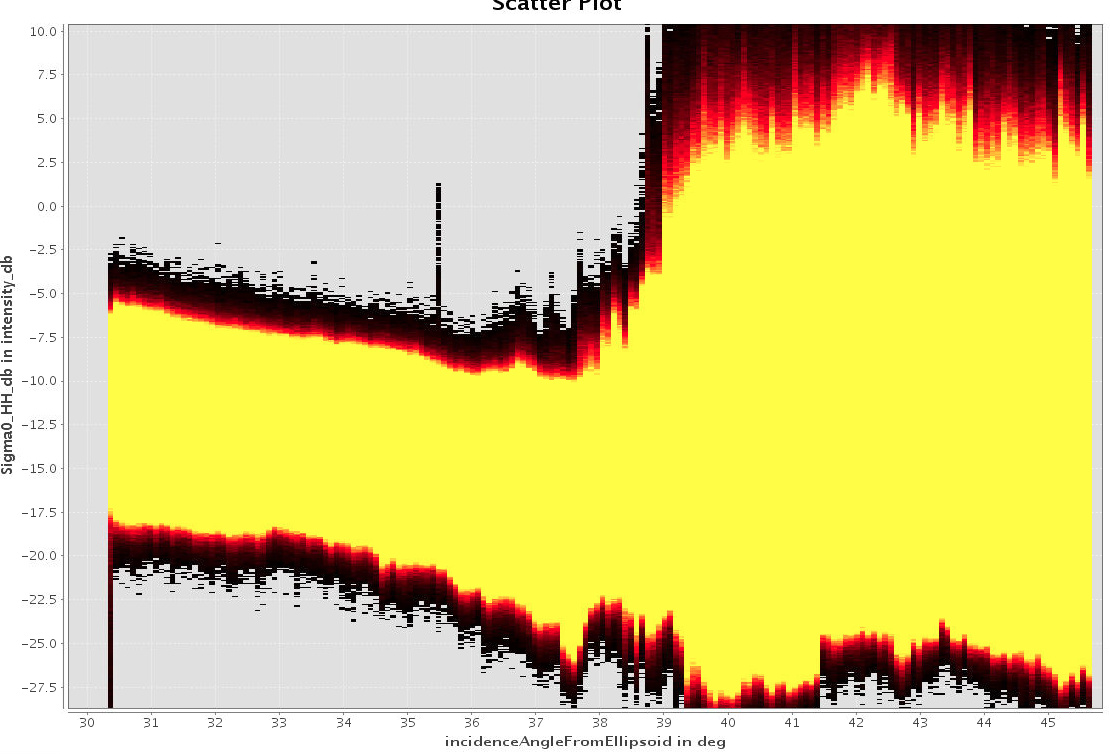
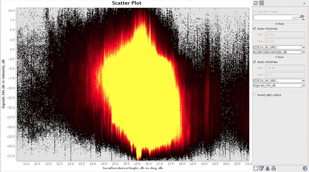
In order to see the dependence between the Sigma0 and local incidence angle, I plotted the Sigma0_HH band against the local incidence angle and incidence angle from ellipsoid and got the following results
- Incidence Angle From Ellipsoid
- Local Incidence Angle
The above two plots show completely different dependency. Figure 1, with incidence angle from ellipsoid shows inverse correlation between Sigma0 and incidence angle from ellipsoid from 30.5 to 38 degrees but beyond 38 degrees the relationship is not clear.
In Figure 2, the relationship does not seem to be there at all.
- Is there a dependence between Sigma0 and incidence angle?
- Does the Sigma0 need to be corrected for local incidence angle? If yes, then is Gamma0 a way to go about it (as Gamma0 includes the correction already)?
- Is Gamm0 a better band for land and sea-ice?
Please let me know if there is any clarification needed from my side.
Thanks
1 Like
How can I make the incidence angle normalization
by applying Radiometric Terrain Flattening: Radiometric & Geometric Correction Workflow
1 Like
hi chen, i have some questions about this formula. Does this formula represent the correction of the incidence Angle in snap? Thank you for your attention