I run the Chlr processor using the C2X-Nets. As I run of a river I set the salinity to 0.1 and the temp to 25C
All the rest of the parameters are default with the exception of the “No uncertainties”; the processor
works well to separate the water body but the detected chlr, is way lower than a local sampling done (at lease 1 magnitude of volume). Any suggestion?
You input Sentinel-2 (L1C) products and adjust the parameters in the second tab and then run it.
The chlorophyll and suspended matter concentrations are then stored in the conc folder:
The quality can be different for different regions. You should have insitu data to compare the results with real data.
As @ABraun said, you.can provide salinity and temperature to improve the results.
Also the factors and exponen for tsm and chl computation can be adapted to match your region.
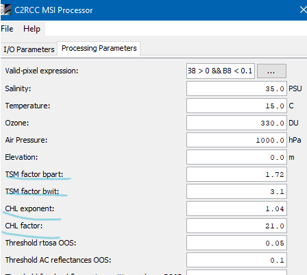
You have to find out which values are best.
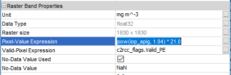
When opening the properties for the band you can edit the values.
Once you found good values you can provide them to the processing.
Hello mr.
I do not want to use Snap processors to estimate chlorophyll-a.
I would like to estimate chlorophyll-A in MATLAB software.
Does for input the Sentinel-2 L1C (TOA) data in MATLAB software require the atmospheric correction of Sentinel-2 L1C (TOA)?
Thank you Mr.
Yes, this would improve the accuracy of your results. There are some where the AC in negligible, but most computations benefit from an atmospheric correction. You could use the Sentinel-2 L2A data.
I have the Sentinel-2L1C image of April 4, 2019 from my case study.
But, the Sentinel-2L2A image of April 4, 2019 is not available in the database of the ESA (https://scihub.copernicus.eu/). please guide me.
If it is not available, you would need an atmospheric correction software. The common choice would be Sen2Cor plugin to SNAP (also possible to use stand-alone on command line). This should create the same product you would download from SciHub. Download here https://step.esa.int/main/third-party-plugins-2/sen2cor/
and make sure you read the documentation. In case you run into problems, search this forum for Sen2Cor, because here is wast number of problem solving discussions - narrow the search also to version you use.
There are also alternative ways to do atmospheric correction, and the second obvious choice to try is iCOR-sentinel2-sta if you use SNAP, as it is available through “Tools/Manage external tools” menu in SNAP. I did not try iCOR yet, Sen2Cor works, but may not be that obvious to operate properly at first.
I am not aware of other tool specifically for computing chl-a or TSM in SNAP, but you can of course use the Band maths tool in to try any algorithm based on band math published in scientific papers. In most cases you need L2A product (downloaded or created in SNAP from L1C), need to make sure all bands in the algorithm are rescaled to common resolution, then apply the formula from the paper.
Actually, if you are working on inland water bodies with chl-a content mostly in range 0-60(100) ug/l, you can even try my own algorithm for chl-a from article:
Brunclík, T., Danquah, K. a. B., 2018. Relativní radiometrická normalizace pro monitoring chlorofylu-a ve vodách pomocí družice Sentinel-2. Chemické listy 112, 866–869. (http://www.chemicke-listy.cz/ojs3/index.php/chemicke-listy/article/download/3244/3215/)
The article is in Czech, unfortunately.
The formula is: chl_a = 59.1770 * (B05/B04)^2 - 77.2041 * (B05/B04) + 23.2527 , where B05 and B04 are bands 5 and 4 of Sentinel-2 L2A image
and I would be curious if it gives reasonable results outside the area it was developed on. I additionally use a relative radiometric normalization on the L2A image, but for clean imagery (minimal cloud cover, no uncorrected residual haze) the algorithm works with satisfying precision without it for me.
I personally use GRASS GIS or QGIS for the computation, where it is is possible to mask out non-water areas or avoid them simply by dividing the whole formula by a water mask band, where water is 1 and land 0. Division by zero produces no-data value in QGIS, effectively limiting the computation results to water areas only. Not sure if that would work in SNAP, but you can use multiplying by the mask if it does not, getting zero instead of no-data outside water areas.
You would need to compare the processing results with in-situ data and then adapt the factors until they fit. Just usual research.
Or @abruescas do you have another suggestion?
No initially i just tried mosaicking with 3 month raw data and then i run C2RCC processer
…
From the S2-C2RCC image I extracted pixel value of chl-a for the months of August 2018 and others
When i try to compare both in-situ and Sentinel-2 C2RCC Chl-a value Plot like this below
In this case toward land my in-situ chlorophyll value is in increasing order but same time S2 derived chl-a value decreasing order toward land. i think this pattern lead negative trend line ,i would like to know conclusion for this scenario
what may be the reason for decreasing value of chlorophyll-a for sentinel-2 C2RCC
Sametime sentinel-2 images gives me strange value for particular place , -If know the reason please let me know