The “OCEA06” training at this link Copernicus RUS Training Materials - eo science for society (esa.int) may also be useful for you
And on the website that @marpet mentioned above, as he was saying you can get more help on the tutorials (highlighted in yellow below) or contact the helpdesk via the “@” icon (also highlighted in yellow below, and which will lead show you the helpdesk’s email address: altimetry.info@esa.int)
Excuse me, if it were possible, do you have any guidebooks or videos about using BRAT with the rivers?
Thanks
Perfect morning
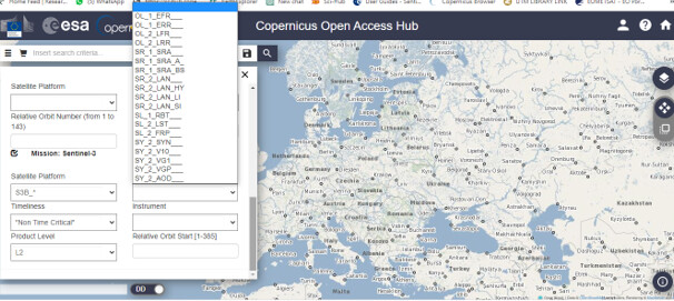
Excuse me, the product type on this picture: what should I choose from these choices if I want to work with altimetry for the rivers?
Thanks
Hello, i have the same problem with you. Did you find any solution? For your case, i am not sure if Sentinel3 can helps you. SRAL i think give us data 300^2 m per pixel.
For altimetry you also have now the Sentinel-6 option, which you can find in the EUMETSAT Data Store. I have not used it, and I am not sure about the convenience for river levels.
1 Like
Thank you for your answer. At the and i will try to use data from sentinel 6. But is not my first choice, because i already use data from sentinel 3 from OLCI and SLSTR instrument. Will see!