Thanks ABraun - changing that param to 16 worked!!
HI Mdelgado, I have been reading your paper “Measuring Ubrban Subsidence in the Rome Metropolitian Area” and I have some questions regarding the combination of PSI measurements from ascending and descending orbits.
- Would there be any issues relating to the 6 day gap between ascending and descending scenes?
- Also do you have any example code or the model in ARC that you used for combining the ascending and descending PS points in the vector domain?
Additionally, when performing the PSI analysis multiple times, to develop a monitoring system similar to that as described in https://www.nature.com/articles/s41598-018-25369-w/. Is there anyway of matching up the coordinates of PS between different iterations. Say if I process with 20 scenes and then 21 scenes.
Thanks, Harry
We have merged average LOS velocities, so no issues with the 6 day gap.
The code is based on the formulas used shown on the paper with the correspondent bibliography.
Regarding position, the PS should match pretty much (small shift might happen based on the accuracy of the software used). Otherwise they will not be PS. At least I understand it in that way.
2 Likes
This error is because the user didn’t provide the full path to the gpt executable in the /snap/bin folder in SNAP2STAMPS. I made the same mistake by providing the path to snap/bin and not snap/bin/gpt
Hi guys!
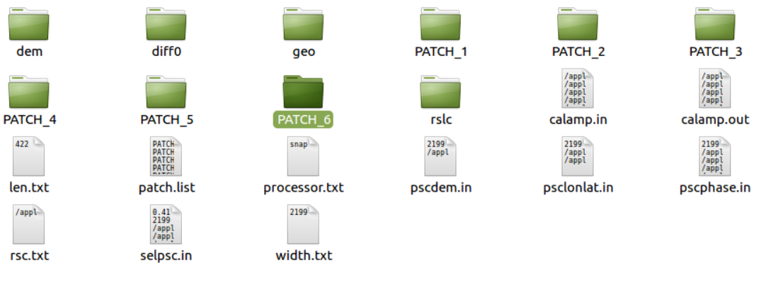
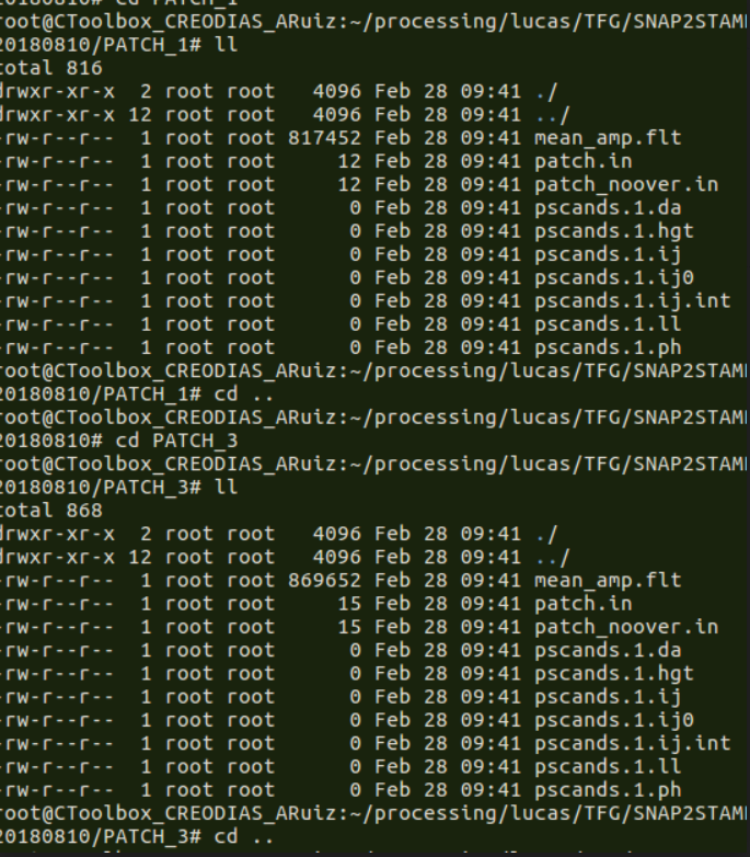
I have some problem with my results on my snap2stamps package, after run the mt_prep_snap, I have no ps candidates and only 6 patches as result. About the other steps, I didn’t find any messages error. It’s like that:
and
Someone can help please or tell me where I’m making a mistake,
thanks a lot!
the files in the folders are not your PS candidates. These are just the files containing their information.
Furthermore, you define the number of patches yourself, in the mt_prep_snap command.
So unless you don’t start the matlab processing and find errors, it looks all fine.
Additionally, I recommend creating a separate folder for the StaMPS processes. Simply create a new directory (at any location) and execute mt_prep_snap here. This helps you to keep the structure clean and doesn’t mix up the original files exported from SNAP (dem, diff0, geo, rlsc) with the ones created by Matlab later on.
Please check the interferograms and the amplitude images generated.
Provide us with some pictures, opening them into SNAP
Hello all, I have some questions I hope someone can help with. I understand restituted orbits are available within 24 hours of sensing, and these are automatically used by snap2stamps if the precise orbit data is not available. Does the restituted orbit data provide good results with StaMPS?
I would like to make an experiment to compare results from precise versus restituted orbits. How do I specify restituted orbit files in the snap2stamps workflow? I want to simulate the situation where I do not have the most recent precise orbit data…
For monitoring volcanoes It would be really great if we don’t have to wait 21 days for the precise orbit files!! Thanks, Mark
Hello, any idea how to update lon/lat coordinates using the residual topographic information of PS estimated during stamps steps ?
I found a good approach here : https://www.mdpi.com/2072-4292/11/11/1258
That uses the equations below :
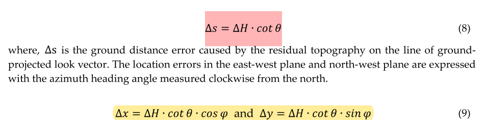
Theta is the look angle stored in la2.mat as la
Phi is the heading stored in params.mat as heading
And delta H how can i calculate it ?
Hi! Very nice!
I believe that the delta H is the dem error, that should be saved in a mat variable… (I need to check which one or how is called).
Are you thinking to share with the community the script one done?
That would be very useful
Best
Of course. You can also add it to the next release of snap2stamps as a geocoding step after stamps.
Let me know about how to find the DEM error as soon as possible.
Thanks,
do I must shift snap7 to snap6 in order to enjoy the package?
The current version run smoothly using SNAP 6.
If you update to SNAP 7 please update the xml when using the Enhanced-Spectral-Diversity operator, as now include other tags. This operator is used in the coreg_ifg_computation.xml and coreg_ifg_computation_subset.xml
In the next release it will be updated for SNAP 7 and python 3
I would recommend skipping 7 and supporting SNAP 8 that is getting closer to release.
Thanks @mengdahl!
Is there any date already scheduled for the next release?
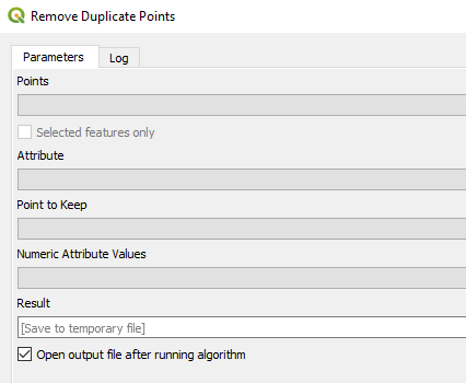
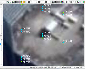
Dear All, when viewing results I have noticed there are sometimes more than one PS in the exact same location. Is this a limitation of the lay/long location accuracy?
Thanks,
Mark
how many digits are exported in your case?
Actually, duplicate points are removed in the weeding the latest.
Well… in the last version you can decide even not to delete neighbour PS.
Can you share your parameters? getparms?
And also check the number of decimals on the coordinates? (I agree with @ABraun)
Best
Below is a screenshot of the points, labelled with the longitude coordinate:
Unfortunately I cannot run getparms because I already deleted the project folder.
So there is a parameter to eliminate duplicates?
Thanks for your advice,
Mark
QGIS offers to remove duplicate points based on their attributes. You could calculate a textstring containing both coordinates ($x||$y) and use this attribute