Ok sir…I’ll try…
Sir, Is there any tutorial on water cloud model for soil moisture estimation? I went through the journals that you have suggested earlier. But, still confused on the equations and input parameters.
Have you seen these two?
- https://eo-college.org/resource/soil_moisture_tutorial/
- https://eo-college.org/resource/soil_moisture/
You can download them after registration
There is no tutorials (as far as i know) on how to apply the Water Cloud Model (WCM). If you need to learn bit about about soil moisture, the resources provided by @ABraun will help you.
WCM is a modelling method, it is not something very simple where you can use, lets say the band math of SNAP and someone make a tutorial for it. To do modelling, it mainly requires two things:
- field data
- Programming language to apply the mathematical equations
I would suggest you to find more articles on how to apply WCM and try try to understand all the steps
Hello Everyone!
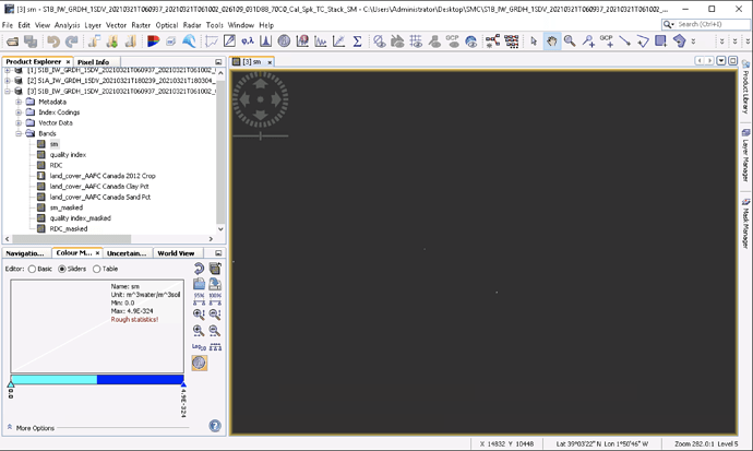
I followed the same tutorial as Arset to create a Soil Moisture Map, using images from Sentinel1 in Europe instead of images from RadarSat2, but the result is this.
I think in particular I didn’t understand how the LandCover and LandCoverMask work, in the tutorial (from what I understood, thanks to her pronunciation) she just uses that MultiAngle_FullGraph without changing anything.
Could someone tell me what changes are needed to get something meaningful? Thanks! 

P.S. In the Multi-Angle-Inversion IEM, I used the VV1-VV2 polarisations instead of HH1-HH2.
Please share a link to the tutorial you are referring to.
Is this one, mentioned above.
Hello Monty, I would like to know how to use the Multi-Angle-Inversion IEM or multi_polarisations in SNAP, my sentinel-1
image is in vv and vh polarisations however the Mlt angle or polarisation IEM request hh polarisation which is not available.
Hi all,
Has someone solved SMC retrieval using the SNAP tool for soil moisture estimation yet?
have you seen this? I want to extract soil moisture from SAR data
@ABraun yes, I have seen it. but I want to know if anyone have done SMC extraction using soil moisture toolbox in SNAP under the tab Radar>> soilmoisture. This is still a question why only RADARSAT data gives output asper the discussion by @puneeth89 and @Monty
sorry, it was not clear from your initial question that you are referring to the soil moisture tools within SNAP.
Dear, Sentinel-1 have daul polarization while RADARSAT have quard polarization.
the toolbox which you have mention is only work in quard polarization
I urge anyone interested in S1 and soil moisture to check the reference articles listed here:
Sentinel-1 for Surface Soil Moisture - eo science for society (esa.int)
Hello Andreas, @ABraun ,
I was curious as I have utilized this method but when I got to the SM-Dielectric Modeling, the result was a blank screen. I am looking for an area in the United States and it seems there is no crop, sand, or clay land covers here. I believe that is the issue. Could you advise?
Thank you,
Marshall
