I am using ALOS-2 data to perform SAR offset tracking experiment aiming at the detection of land slide. Now I have met some problems and I'm wondering if anyone has met the same problem and can give me a hand.
Q1: I checked the SNAP software manual and the “offset tracking tutorial”, both are saying this toolbox can detect the deformation of glacier. Can the toolbox also be used in other fast moving cases, such as land slide?
Q2: I performed offset tracking experiment using S-1A GRD data according to the “offset tracking tutorial”, and I get good result, everything goes well. But, when it came to ALOS-2 data, there are problems:
My processing steps are:
(1) Import SAR sensors-ALOS2 CEOS-VOL-ALOS2177800820-170907-FBDR1.5RUA.
I imported master and slave images by this way, and it works well.
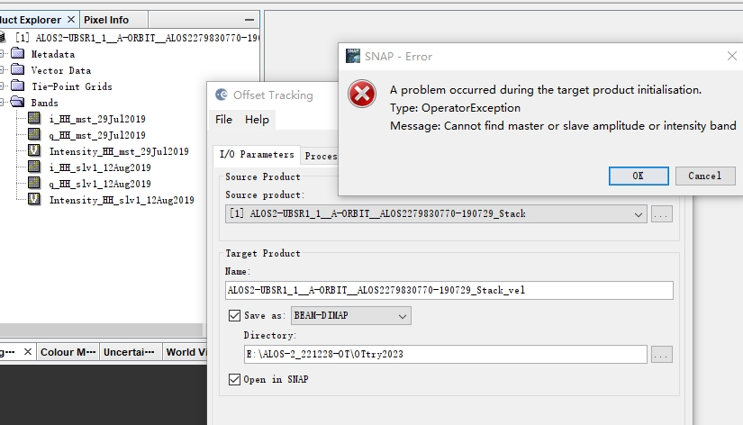
(2) DEM ASSISTED COREGISTRATION
In this step, an error occurs, please see the picture I upload, there is a red “0” at the bottom left, no output files. I can not move on.
(3) Are there any tutorials on ALOS-2 offset tracking? Or, someone expert could offer me a standard processing chain on ALOS-2 offset tracking?
(4) For ALOS-2 offset tracking, which format(level) of data should be used? L1.1 or L1.5?
Hello,
I am facing the same problem. Have you found any solution recenty? I tried to perform another kind of coregistration, it worked. But when I tried to run offset tracking I got an errror anouncement, that I need just DEM assisted coregistrated stack.
Thank you
Katerina
Finally found the way:
For Coregistration used: Radar --> Coregistration --> Coregistration. As the “Initial Offset Method” was set “product geolocation”. The coregistration finished successfully.
Then I run offset tracking and it worked, too.
Thank you for your time ABraun
Katerina
thank you for reporting a solution. So “product geolocation” is working for ALOS Level 1.5 data? That would make sense because they already contain a basic form of geocoding.