Good day! I ask for help. I am building a bathymetric map of the Kama (Russia). for this I use data from an echo sounder-chartplotter and satellite images on low water levels in autumn 2010. On the ESA website I downloaded an ALOS PRISM image dated November 18, 2010, but it turned out that it was not in Geotiff format (and not in JPG). To open it, the support service prompted to download and install SNAP. I am not a GIS specialist, so I can probably figure out the work of the program, but this will take time, but it is not - there are 4 months left until the new season, and there is still a lot of work on the map. I ask for help in the step-by-step guide for opening a snapshot in SNAP. Is it possible to somehow convert it into the KMZ format to open the image in Google Earth - I carry out the correction of the depth map in this program, and therefore it is extremely necessary to be able to take a picture in Google Earth. If it is interesting, I will describe the process of building a bathymetric map after its construction on my website.
can you please tell us where exactly you retrieved the ALOS PRISM data and which in which format or product level?
The products are downloaded from the ESA website http://alos-ds.eo.esa.int/socat/ALOS_PRISM_L1B/AL1_OESR_PSM_OB1_11_20101118T075328_20101118T075333_025662_0248_2480_0001. After downloading, the compressed folder contains the IMG files, the support specialists said that they can be opened in SNAP.
I am currently waiting for registration for the and will try once I was granted access
This is a L1B ALOS PRISM product, according to the handbook and one of the metadata entries this is a CEOS format (Band Sequential). I checked the code briefly and the s3tbx seems to have a CEOS PRISM reader in there…
So have you tried to read the product in SNAP? @marpet any tip? Should he point to the directory of the CEOS or one of the files?
The data provided on this ESA page seems to have a different format as what is supported by S3TBX.
S3TBX supports this format:
Document - Level 1 Product Format - (jaxa.jp)
The data provided on this page looks more like the ESA SIP format supported by the reader in the S2TBX.
I wasn’t able to download the data. The login didn’t work properly.
If the data is compatible, try to open the *.MD.XML file, @River-plate.
You can also try to drag and drop it from the files system explorer onto the Product Explorer in SNAP.
@oana_hogoiu can you have a look too?
I can confirm that the import neither works via the .zip file nor the .xml inside. I also tested the .zip file inside the folder structure, but it also is not recognized. When enter the lowest directory, I can open
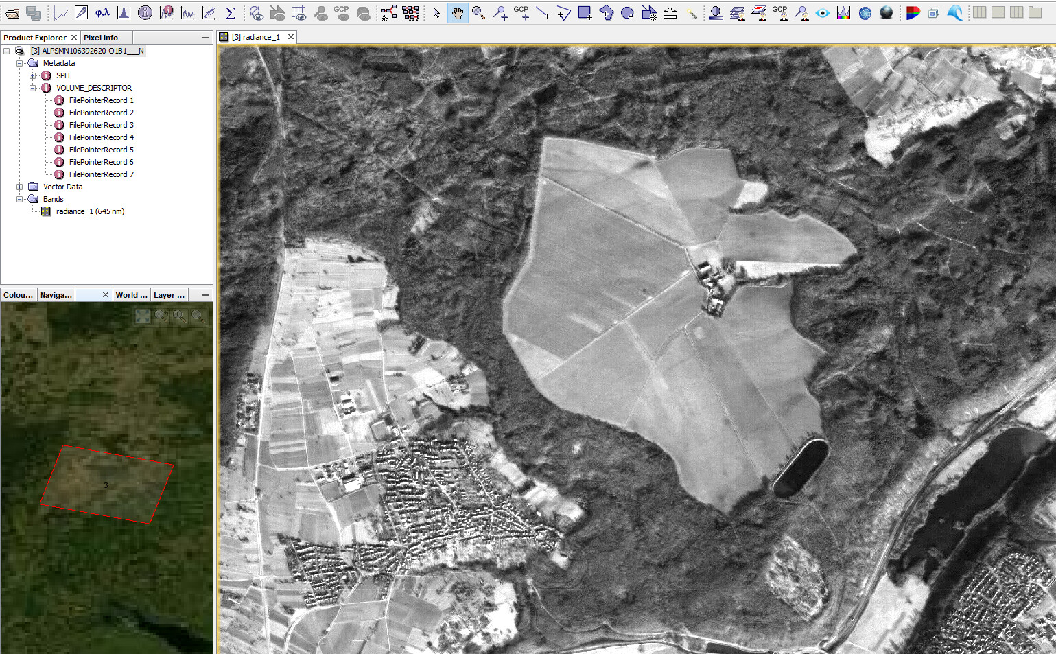
Selecting the VOL file results in one band which is displayed and located correctly. So the data format is partially readable in general, but not fully as it should.
@River-plate, you can also try to unzip the package and fetch the product from inside and use that with SNAP.
Can you post a list of the contents of the SIP (zip) file? i.e. unzip -l
more input… the ALOS PRISM L1B - Earth Online description page states:
Two different Level 1B product types (Panchromatic images in VIS-NIR bands, 2.5 m resolution at nadir) are offered, one for each available sensor mode:
- PSM_OB1_11 → composed of up to three views; Nadir, Forward and Backward at 35 km swath
- PSM_OB2_11 → composed of up to two views; Nadir view at 70 km width and Backward view at 35 km width.
All ALOS PRISM EO-SIP products have, at least, the Nadir view which is used for the frame number identification. All views are packaged together; each view, in CEOS format, is stored in a directory named according to the view ID according to the JAXA naming convention.
So those SIP files should contain 3 CEOS directories, one for each view. SNAP should be able to reach those one by one!? How do we tell SNAP to read the CEOS data?
This is the top folder:
Mode                 LastWriteTime         Length Name
----                 -------------         ------ ----
d-----        11.02.2021     10:26                AL1_OESR_PSM_OB1_11_20080123T103009_20080123T103014_010639_0320_2620_0001
------        17.04.2020     17:56          93759 AL1_OESR_PSM_OB1_11_20080123T103009_20080123T103014_010639_0320_2620_0001.BID_0320_2620_N.PNG
------        17.04.2020     17:56         181909 AL1_OESR_PSM_OB1_11_20080123T103009_20080123T103014_010639_0320_2620_0001.BI_0320_2675_B.PNG
------        17.04.2020     17:56           7490 AL1_OESR_PSM_OB1_11_20080123T103009_20080123T103014_010639_0320_2620_0001.MD.XML
------        10.04.2019     03:19          51891 AL1_OESR_PSM_OB1_11_20080123T103009_20080123T103014_010639_0320_2620_0001.QR.PDF
------        10.04.2019     03:19          91886 AL1_OESR_PSM_OB1_11_20080123T103009_20080123T103014_010639_0320_2620_0001.QR.XML
------        17.04.2020     17:56            258 AL1_OESR_PSM_OB1_11_20080123T103009_20080123T103014_010639_0320_2620_0001.SI.XML
------        07.05.2019     00:30      263404580 AL1_OESR_PSM_OB1_11_20080123T103009_20080123T103014_010639_0320_2620_0001.zip
inside AL1_OESR_PSM_OB1_11_20080123T103009_20080123T103014_010639_0320_2620_0001
Mode LastWriteTime Length Name
d----- 11.08.2017 10:38 ALPSMB106392675
d----- 11.08.2017 10:38 ALPSMN106392620
and inside ALPSMB106392675
Mode LastWriteTime Length Name
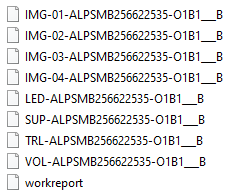
------ 11.08.2017 10:38 80421026 IMG-03-ALPSMB106392675-O1B1___B
------ 11.08.2017 10:38 80421026 IMG-04-ALPSMB106392675-O1B1___B
------ 11.08.2017 10:38 80421026 IMG-05-ALPSMB106392675-O1B1___B
------ 11.08.2017 10:38 80421026 IMG-06-ALPSMB106392675-O1B1___B
------ 11.08.2017 10:38 23400 LED-ALPSMB106392675-O1B1___B
------ 11.08.2017 10:38 13142680 SUP-ALPSMB106392675-O1B1___B
------ 11.08.2017 10:38 16920 TRL-ALPSMB106392675-O1B1___B
------ 11.08.2017 10:38 3240 VOL-ALPSMB106392675-O1B1___B
------ 11.08.2017 10:38 5483 workreport
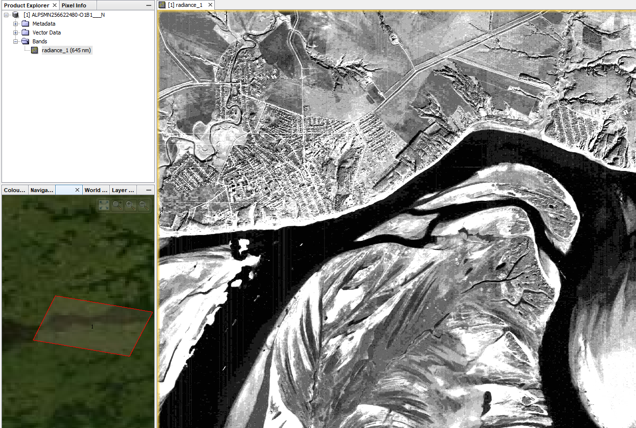
Thanks for the screenshots ABraun! My God, what a beauty the low water level opens up on Kama - super! I correctly understood that after I open the SNAP, I will simply drag the IMG file into it and immediately see the pictures ??? If everything is that simple in SNAP, then tonight I’ll install it on my computer and try it. So another question - it is clear that probably in SNAP I will not be able to draw depth isobaths along the gaps that are visible in the image, this allows Google Earth to do this, but there you need to upload an image in KMZ format - how can you convert an image in IMG format to this format!
the IMG file also results in an error, the only file which is readable is the VOL file and it shows the image.
The directory content you show Andreas looks like the format which is supported by the reader in S3TBX.
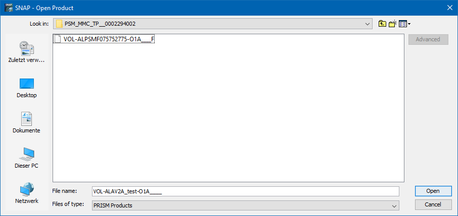
Here it is best to open the VOL- file.
It is the only selectable when you choose PRISM Products as File type at the bottom.
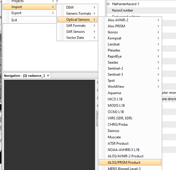
Or you use directly the menu entry File / Import / Optical / ALOS/PRISM Product
As already said. the data needs to be extracted first to get to those files.
You can export to KMZ from the context menu of the view.

Or File / Export / Other / View as Google Earth KMZ.
But you must reproject to WGS84 first. Required by Google Earth.
I sorted out the IMG files yesterday. To do this, the post of ABraun in autumn 2020 helped that AVNIR-2 are now available in the ASF service - I downloaded several AVNIR images and understood why there are 4 IMG images in each file. The pictures are all the same, they just have different contrast settings. Likewise, PRIZM - for forward, nadir and backward views, there are 4 images in the files, I think they are also the same, but processed differently. So it is not necessary to open IMG and VOL in SNAP?
And can you reprogram in WGS84 directly in SNAP? So it would be just fine if you import an image in KMZ format directly into SNAP. In addition to KMZ, I also need a snapshot in SQLite format - I upload a snapshot in this format to a mapping application on Android for navigation. The Global Mapper program coverses into the SQLite - the main thing is to create a KMZ!
The 4 IMG files represent 4 tiles of the product. Together they make up the full scene.
No, you can’t import KMZ into SNAP. You can only export to it.
In SNAP you can reproject to WGS84, yes. But I just saw that there is a problem when doing this with the ALOS data. I’ve created this issue:
does it contain vectors or also rasters? In case of vectors, it is possible to convert to Shapefile and import them into SNAP.
That is, if you reproject it in SNAP, the snapshot will not be linked correctly? In principle, this is not a problem, this is how it is solved. Cut the image into smaller parts and upload it to Google Earth - there you can make a binding. Or, if there are still problems, then it is even easier to do - I make screenshots of the picture in SNAP in jpg format (like a simple picture) and then calmly link it to Google Earth - as I already did with some pictures in 2010. Why is it even better to link in Google Earth - the lower the image resolution, the greater the error, already images with a resolution of z17 (i.e. about 1.2 meters per pixel) are not correctly aligned, ALOS PRISM has even less resolution - 2.5 meters per pixel, and the “longer” the snapshot, the more error occurs. Therefore, in order to obtain a high-quality bathymetric map, the image will have to be cut into pieces anyway.