I managed to activate the snap2stamps chain from start to end, and finish StaMPS inside Matlab.
I did it successfully for ascending data.
I’m trying to do the same exact chain for descending data of the same area and time, but coreg_ifg_topsar.py gives me error -
Error: [NodeId: Subset(2)] Operator ‘SubsetOp’: Could not parse geometry.
– org.jblas INFO Deleting /tmp/jblas7283355022306156205/libgfortran-4.so
– org.jblas INFO Deleting /tmp/jblas7283355022306156205/libjblas_arch_flavor.so
– org.jblas INFO Deleting /tmp/jblas7283355022306156205/libjblas.so
– org.jblas INFO Deleting /tmp/jblas7283355022306156205/libquadmath-0.so
– org.jblas INFO Deleting /tmp/jblas7283355022306156205
Is there any reason for a problem with descending data?
So at the beggining I defined AOI and got the error.
Then I removed the AOI definition from the conf file and tried the coreg_ifg part again, the error remained.
I thought maybe the former step (splitting) kept that AOI information somewhere, so I started the whole process from the beginning. Still, the error remains.
When I run it with the AOI of the ascending data, it works.
Ah! You are defining the AOI in STaMPS and STaMPS converts it into a geometry for the SubsetOp.
So, this is either a problem in STaMPS or in your configuration.
I’ll move this from the SNAP category to the STaMPS category.
Please show us your code and how you feed the AOI into the subset operator.
As the error message indicates there must be something wrong. Which version of SNAP are you using?
Hi @marpet,
I’m using SNAP 8.0.3, i.e. the updated one.
As I wrote, I completely removed any AOI definitions, started the whole process from the beginning, and still got that error message.
you can check which xml was created by snap2stamps during the processing in the graphs folder of the processing directory (not the snap2stamps directory). There is a graph file belonging to the coregistration process with the current datasets as inputs. Maybe checking the definition of the subset in this file gives an indication about the error source.
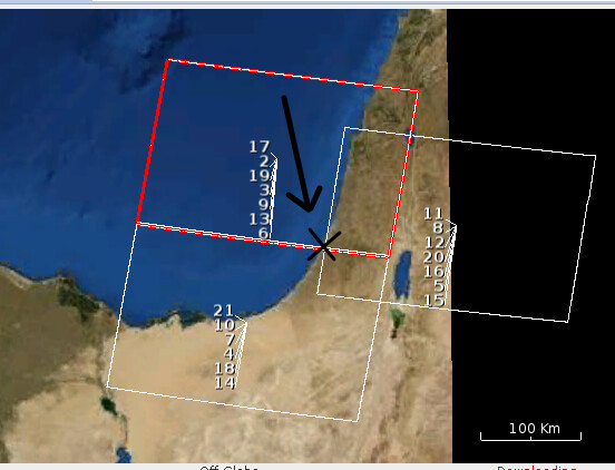
It took me some time, but my conclustion is that this piece of data suffers from bad luck…
The SA1 descending path borders fall exactly at the city I’m interested in (marked with black X), and cut it to two frames from N to S, and two frames from W to E:
So, that’s right - there is an area of overlap, and the upper left rectangle should include that city, but look what happen after spliting and applying orbit correction:
The orbit correction tilts the rectangle and misses the city!!! (where the red arrow points to).
So I call that bad luck, and apparently that’s why I had problems with the subset coordinates. Ha ha.
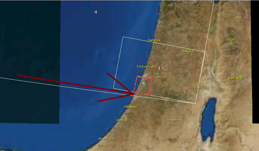
The Ascending frame doesn’t suffer from this problem and therefore there were no problem processing it:
p.s.
If I understant correctly, mt_prep_snap + stamps(1,1) make the trasnformation from Range-Azimuth grid of sentinel to Lan/Lot grid.
I need the elavation data as well, and I see there is a hgt.mat file at the PATCH folder. Is that’s what I need?
I want to present the result on 3D grid.
p.s. 2
The abbreviation ‘p.s.’ is funny in this context.