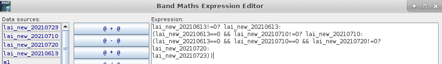
I am trying to create multitemporal 10-day cloudy-free LAI composite using time-coincident images from Sentinel-2 to Sentinel-3. I am trying to perform that task using gpt graph. So far I masked LAI images with their corresponding cloud masks. The next step would be to create a composite considering the closest cloud-free S2 pixels to Sentinel-3 overpass. I was trying to use Band math tool to accomplish that. Here is an example for 4 LAI images when I used the following expression:
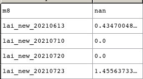
Unfortunately, if one of the images has value of 0, the conditional statement gives me NaN value as shown below (m8 indicates the final output). Do you know how to write the statement properly? Or maybe there is another solution?
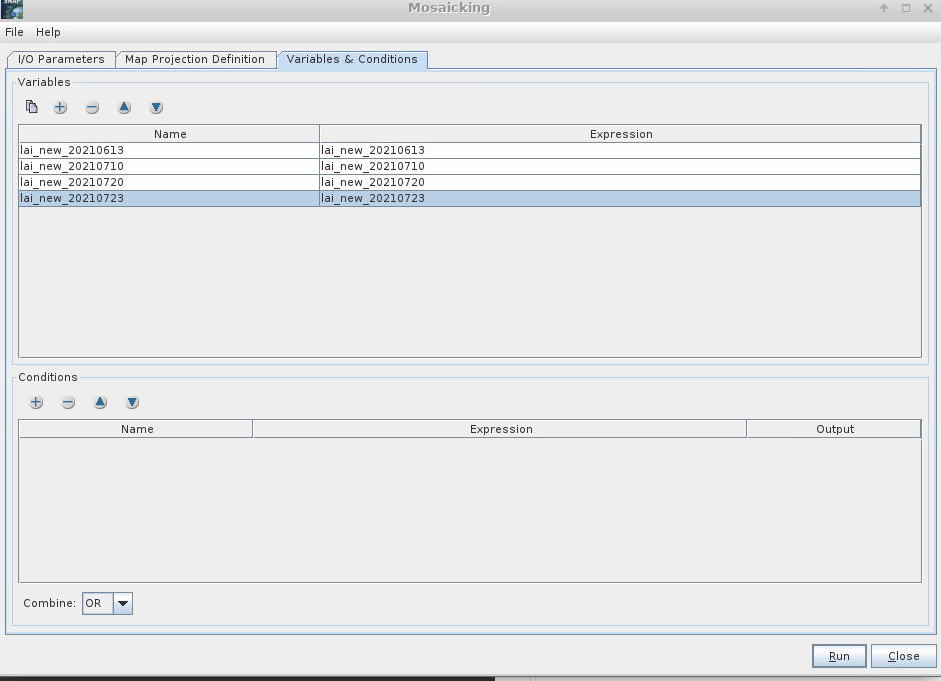
If you only have one band, it should be similar of what you were trying to do with BandMaths. Select the variable and in the expression you should indicate the valid pixels.
By the way, the mosaicking will merge images that cover different areas. If you want a temporal merge you have to use L3Binning. I am not sure what is your case.
First, I masked my lai images, and then I merged all four bands to get raster stack (band1:lai_new_20210613, etc.). The images cover the same area. I would like to get cloud-free temporal mosaic from those images. In my case I have 4 lai bands to select valid pixels. However, I would like to derive non-cloudy absolute value for each pixel.
Binning can be done over space and or time to pool data from multiple images. One issue when combining images is that pixels near the edge of a pass are highly correlated because the ground footprint of a sensor pixel is larger. The quality of edge pixels tends to be lower due to longer atmospheric path lengths. Mosaic will end up overweighting these lower quality edge pixels. Binning gives each sensor pixel equal weight.
Combining geophysical products from multiple sensors can encounter problems due to different spatial patterns of estimation errors for each sensor. You may want to examine images of the differences between the two sensors to see how severe these differences are for your data.