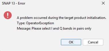
Firstly thank you for reading this, I am rather new to Remote Sensing and am trying to achieve some polarimetric decompositions of BIOMASS L1A SCS data, working within SNAP 13. I have not seen a specific workflow established for this unlike for Sen-1, and I have the following workflow:
Is this an issue with the reader and if so how should I proceed? I might also be completely wrong and the L1A BIOMASS data may already be Sigma0 corrected to begin with, hence no need for calibration…
The BIOMASS Level-1A SCS product is a Single-Look Complex Slant product containing calibrated amplitude and phase information in slant-range geometry. As such, it does not directly provide Sigma⁰ or Gamma⁰ backscatter values. These backscatter coefficients would need to be derived through radiometric calibration and, where appropriate, incidence-angle and terrain corrections. The Level-1B DGM product is the first detected-intensity product in the BIOMASS processing chain and is therefore more suitable for backscatter-based analyses.
Please refer to this link for further information.
So to summarise, L1B DGM is best for backscatter based analysis (i.e. getting Sigma0 or Gamma0 values), but using L1A products for my intended purpose to do Polarimetric Decomposition (geting physical scattering variables) is correct as that necessitates both phase and amplitude only present in L1A products. Safe to say that there is no need to ‘Calibrate’ the L1A data prior to my steps 1-5?
I would appreciate any advice on the workflow, if anyone feels there might be a step missing or there are better parameters to use for my steps.
L1b products lie in the ground range versus azimuth plane, with image coordinates oriented along ground range and flight direction. The standard L1b products are detected, multilook products (six looks), with square resolution cells and square pixel spacing.
The resolution of the product will be 50 × 50 m2. Each image pixel is represented by a real
(amplitude) value, which can be translated to calibrated radar brightness. Thermal noise compensation is not applied by default on data, but the information
to perform the procedure is included in the metadata (Ref. Scipal et al.: BIOMASS: ESA’s P-Band SAR Mission)
I have the same issue. I am working with Biomass L1A Standard Products (L1S), but I am not getting results when applying the polarimetric decomposition workflow. I am reading the images, calibrating with complex and coregistering with complex, after that (applying Polarimetric Matrix Generation, Polarimetric Speckle Filtering, and Polarimetric Decomposition), the graph is failing.
Honestly I skipped calibration and proceeded with my workflow as the first post because I am assuming all L1A products have been already radiometrically corrected>
From BIOMASS data portal:
Level-1a products based on slant-range versus azimuth plane images. Each pixel of the image is represented by a complex value containing calibrated radar amplitude and phase.