Can anyone tell me how the LAi procesor calculates the LAI, where does it get the land cover classification from?
The SNAP L2B algorithm has been developed by INRA and due to the absence of reliable and regularly updated land cover map at a spatial resolution similar to that of SENTINEL-2, the proposed algorithm will rely only on SENTINEL-2 instantaneous observations.
The algorithm uses NN and Prospect as RTM.
You can find further information in the presentation ‘Concepts and methods for LAI/fCover/fAPAR/Chlorophyll retrieval’ by Marie Weiss, shown during the ESA Advanced Land training course 2019
1 Like
Thankyou @Fabrizio_Ramoino. The presentation is interesting, but I’m still a little confused with how the values are calculated. To add to the comfusion, it seems that there is uncertainty within the wider ESA data about LAI
I geberated the following two graphs for the same geolocation and similar time period:
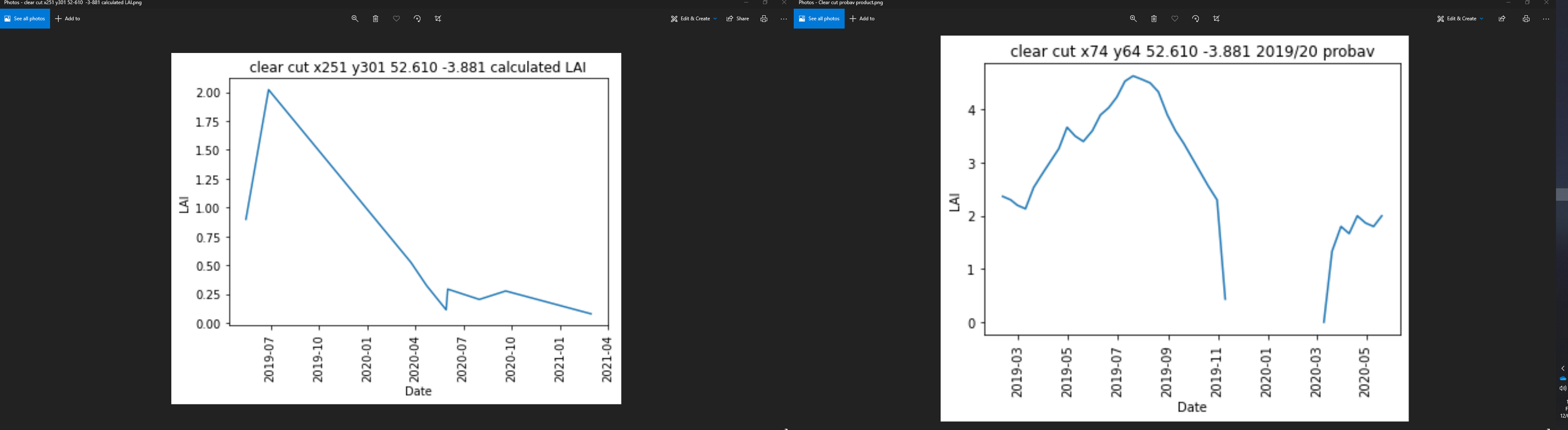
the left hand plot is LAI values generated by the SNAP processor (10m resolution) and the right is taken from the PROBA-V product downloaded from the Copernicus Global Land Service website (300m resolution 10 day average)
As you can see the LAI value is approximately twice the SNAP value,
As a newcomer to both remote sensing and LAI research i find it very confusing that the ESA has suck varying data for the same place!
Remote sensing is a new thing, so we are still learning. It also generates massive amounts of data. Combined with the enormous advances in processing power, older algorithms that relied on simplifications to reduce computational workloads are being replaced with improved algorithms, but there is still a lot more work and processing power needed (cloud shadows need 3-D algorithms that are still too complex for our computing capacity outside intensive studies for small areas). For oceans, in situ data are limited by slow ships in a very big ocean, but even for land sampling can be limited by walking speed in a big forest and rugged terrain. There are also tradeoffs between lower accuracy for a wider range of conditions versus higher accuracy with many “no data” areas.
Implementing multiple algorithms yourself may allow you to understand where they diverge.
Dear Matt,
The article “Validation of sentinel-2 leaf area index (LAI) product derived from SNAP toolbox and its comparison with global LAI products in an African semi-arid agricultural landscape” published by M. Kganyago on Remote Sensing Letters 11.10 (2020) expalins the validation and inter-comparison experiments.
Best regards,
Fabrizio
1 Like
Thanks @Fabrizio_Ramoino, thats a really interesting paper.
It seems that the jury is still out regarding the most accurate product available!
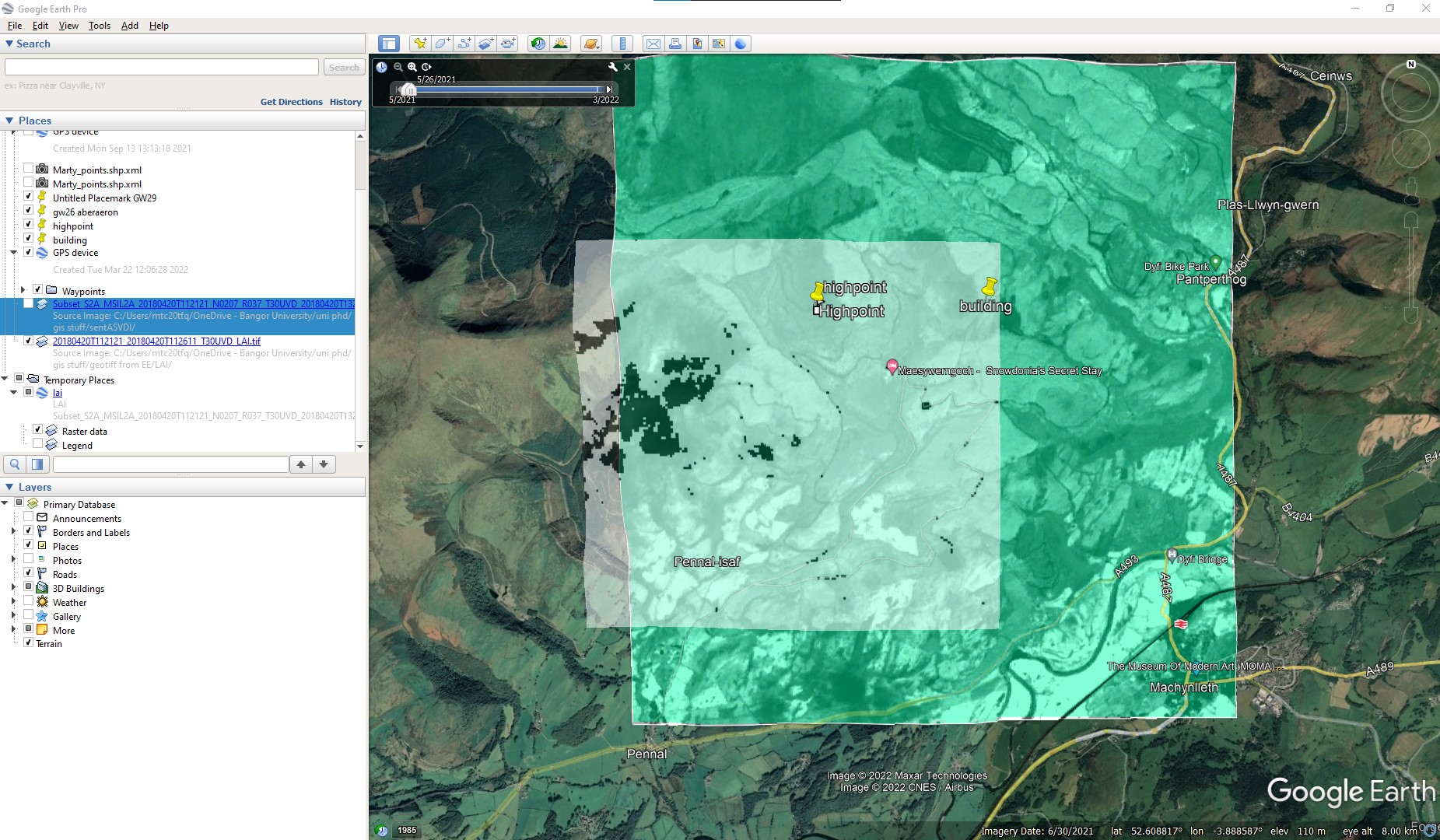
I think I am going to use the SNAP derived LAI values in my model, you can see from the screenshot that for my area of interest the SNAP values are at a much better resolution.
than the Proba-V (centre image). I did a little analysis on these images and found that the Proba-V values average 1 LAI unit higher than the SNAP algorithm, and small scale changes, (the cursor box in the centre and right images are over an area that was clear-cut and you can see from the pixel values that there is a marked difference in the LAI value for that pixel)
If possible I will run my model using both values and see id there is any difference in the interception predicted!
Hi Matt. Canada Centre for Remote Sensing has recently released the leaf toolbox which allows you rapid mapping of LAI using Sentinel 2 data using Google Earth Engine GitHub - rfernand387/LEAF-Toolbox. The algorithms is exactly that specified in the ATBD for the Simplified Level 2 Prototype Processor (unlike s2tbx that has two bugs in it as I was invlovled with Marie Weiss and validation of it , check out the references at References · rfernand387/LEAF-Toolbox Wiki · GitHub). I would say SL2P is adequate for crops and grasslands but systematically underestimates LAI in forests due to lack of canopy clumping in the calibration dataset.
The CGLS algorithms are closely related to SL2P below LAI 3 and then to MODIS above LAI3. I have a presentation at the Sentinel 2 5th validation meeting on this.
Richard Fernandes, CCRS
Thanks Richard, that looks like it could be really useful!
is there a way to set the output resolution to 10m other than when running the task?
edit:
Well i thought it would be useful!
Maybe I’ve done something wrong, hopefully someone will put me right?
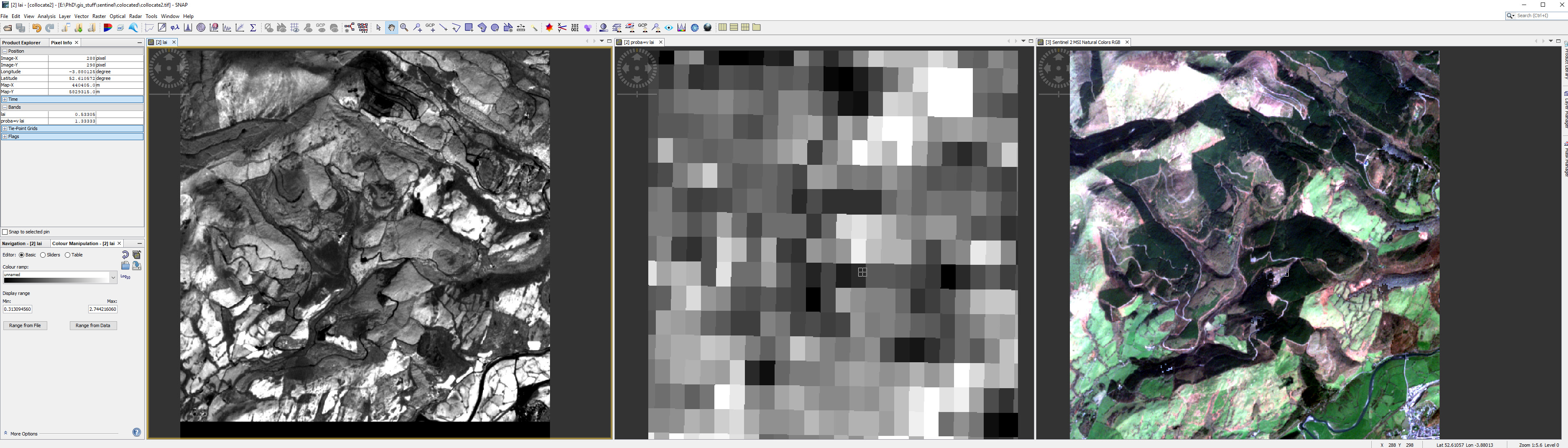
I used the Earth Engine processor detailed in Richard’s post above, and exported the LAI values as a .tiff file as instructed.
The screenshot shows the EE .tif(smaller grey image) and the .kmz file exported from SNAP for the same date. I don’t think anyone could say that the EE processed image is more accurate than the SNAP one!
I would be very grateful if anyone could help me out ![]()