Hi all, I want to calculate intensity value (in dB unit) of both ERS and ASAR images, currently I use the workflow of 1. Apply orbit file 2. Calibration (to dB) 3. Speckle filtering 4. Range-Doppler terrain correction. Is this suitable for these two sensors? or did I miss other corrections?
Also, compared to Sentinel-1, a much higher noise level can be seen in these images. Therefore, the boundary between land and sea is not clear. I wonder is there any suggestion for reducing the noisy level or enhancing the land/sea intensity difference?
Calibration is the most important step. There can still be differences regarding the backscattering intensity when the look direction is different (ascending and descending) - is this the case here?
Can you please post a screenshot on the noise land/sea boundary?
Hi ABraun, thanks for the response.
unfortunatedly the look direction is not the problem here, as all ERS/ASAR/S1 are descending. And I wonder generally a calm sea surface would have a much lower backscatter value in both ascending/descending direction right?
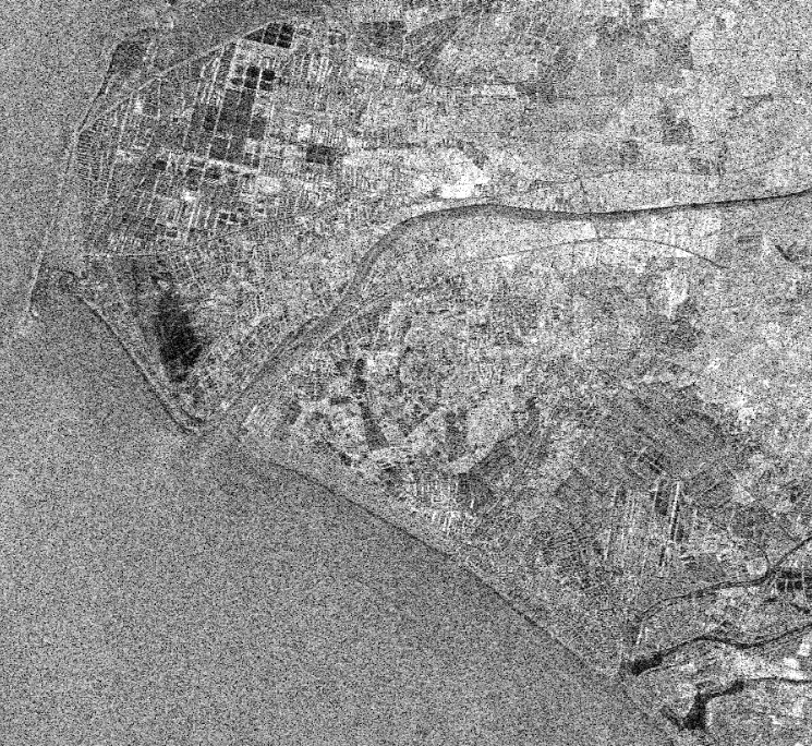
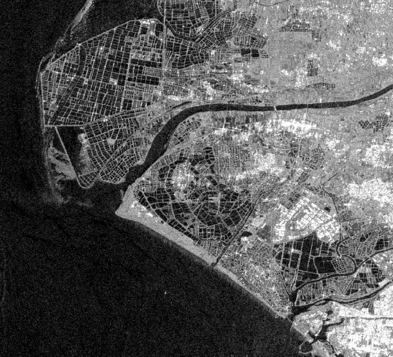
Below are the snapshots of intensity of ERS and S1, both in dB with a same min/max scale. Although of course they are taken at different time, yet the sea surface is much noisy in ERS image.
I think this entirely depends on the smoothness of the water surface at the time of image acquisition.
Additionally, the contrast between land and water is reduced in the log scale (dB) and maybe higher in the linear scale.
Initially I also consider it might be a unique case, but after checking I found that all available scenes of ERS are much noisier than Sentinel-1…
Regarding the linear scale, would you recommend gamma0 or beta0, or it doesn’t matter for the water surface?
for water areas, the calibration level does not really make a difference (except for very large ocean areas where Simga0 reduces the effect of the incidence angle compared to Beta0).
Hi mengdahl, you mean converting to dB should be processed after terrain correction? Yet I wonder the geocoding would significantly distort the image details? Also, then in which condition should I select the “to dB” option in Calibration?
Yes, conversion to dB should always be the last step, so if calibration is your last step, you can choose dB. The reason is that interpolation, calculating the mean etc. should always take place in the linear scale. If you want to obtain the correct mean backscatter of a ROI in dB, you need to calculate the mean in linear scale and then convert the result to dB, otherwise you obtain a biased value.
Terrain correction moves the pixels around to correct geographical coordinates and unless you choose “nearest neghbour”, interpolation of pixel values will take place. If you terrain correct an image that is already in dB the interpolated pixel values will be biased. So always convert to dB at the very end.