I want to perform a coregistration between S1 and S2 using the DEM assisted coregistration in the new SNAP version (coregister S1 to S2).
As an experiment I want to run a coregistration between one S2 image (just RGB channels, 10m) and one S1 image (VV).
My S2 image is in geotiff format my S1 image is GRD, precise orbits applied, no terrain correction. Once I want to run the process
I get an error message:
Do you have an idea for a solution/work around? My first thought is to add some sort of metadata, since the frequency (C-band) is known.
Best regards,
Marvin
Hi lveci,
thanks for your reply. I know that PCI Geomatica has a DEM assisted coregistration which works for both, optical and SAR data (combined), so I was guessing that SNAP would provide the same functionality. However, the program is complaining about missing information on the radar frequency, not the orbit (unless the radar frequency is a part of the orbit state). Is it possible to edit the metadata of S2 so one can perform the desired process?
Best regards,
Marvin
Terrain-correct the SAR image into the same map-geometry as the optical image and see how well it lines up with the SAR image. In theory you should get sub-pixel accuracy even without co-registration.
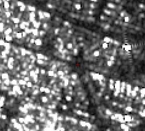
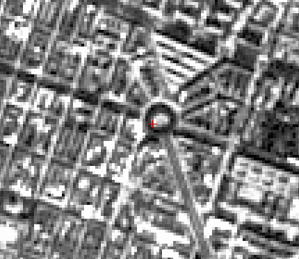
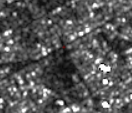
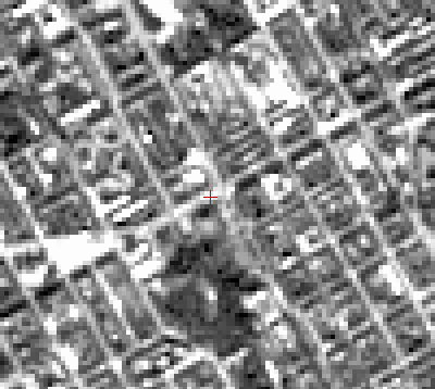
thank you for you answers. here are some example of offsets I get after terrain correction:
middle of roundabout (s1):
same, just S2, red crosshair is on the same location
now an intersection, S1:
same situation, just S2 (crosshair is on the same position):
So as you see, it does not work so well. There is an ofsett of approximately 40 meter. The results get slightly better if I perform an automatic coregistration (not the DEM-assisted one).
Hello @Marvin
Do you have a solution for this problem? I want to use S2 data in combination with SAR data to do some analysis.
Was your answer solved? Kind Regards.
I have your same need (use S2 in combination with S1) and I’ve just reached the goal: same resolution of S1 and S2! You have to use the “Reprojection” processor so you can suit the S1 data to fit S2.
Do you mean that after processing S1 data and doing terrain correction (which includes a map projection option) we have to reproject it using the reprojection operator.
In that case, when doing the reprojection, did you use the option “Use CSR of” to define the projection or did you choose it as a “Custom CSR” or “Predifined CSR”
you should use “Use CSR of” to reproject as S2.
Although I don’t know how usefull is this kind of operation, considering that if you pass from low resolution to high resolution you are gonna miss informations.
Hi Marvin,
did you find a solution for this offset between S1 and S2? I’m in the same situation and I already tried many solutions suggested without results…
Hello @mengdahl
I have tried the way that you have suggested in the former discussions. But here I still have two questions.
After performed the steps of “Terrain-correct the SAR data into the same projection and pixel-size as the S2 data”, I dealt with the “create stack” for the S2(after resampling )and the S1.I get the product of the stack that has the same size and resolution of every bands which contains the VV,VH bands from the s1 and B1,ndvi,etc from the s2.But I was wondering that if the bands from different sensors are really coregistrated? Considering about the indistinct image of the VV,VH,I can’t figure out whether by
if each pixel of the bands from different sensor is actually aligned visual interpretation. Do you have any suggestions?
I found that snap website has released a new tutorial , in this tutorial, they use "the Collocation operator "to merge the s1 and s2, do you know the Similarities and differences between "the Collocation operator "and the way you suggested before?
Best regards,
Juanjuan Yu