I am using RS2 dataset for my research. I want to ask two questions whose answers are very important for me to know.
What is the reference of the DEM generated in Sentinel -1 toolbox. Does it include the above earth features?
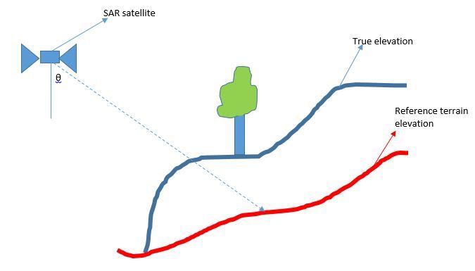
In the figure below, I have True elevation ( Blue color) from slant range DEM in S-1 toolbox option. I want to get the reference terrain elevation (RED color) so as to remove the DEM error. Kindly tell me the procedure to get the reference terrain elevation.
I would be very grateful for your valuable guidance.
I have created the SRTM slant range dem from add elevation otion in snap. I wanted to ask that is that height obtained is above mean sea level or ellipsoid. Moreover, doest it contain the height of the Above ground object.
From question 2, by reference terrain elevation I mean, either MSL or ellisoid.
Sir, which at C-band over forest is somewhere in the forest canopy, what about at X-band?
SRTM heights are referenced to a geoid as explained in SRTM documentation on the web. The DEMs do contain the heights of the above-ground objects if that is where the radar return is coming from. At X-band over forest the radar return is coming from somewhere quite high in the forest canopy, but not only from the treetops.
SAR radar imaging basics —> 1.wavelength in Radar basics . @sushil it seems that when your research will be done all the STEP community members should be added as a co-authors.
I chose a little agressive way of pointing out the fact, that it would be nice to mention step forum in your research. A nice way to say “thanks” and show others that this forum exists and members are active.
Hi Sushil. Don’t worry, you’re not alone, there’s a lot more here climbing the SAR interferometry and polarimetry ladder to use this huge quantity of new SAR data available . Non parametric all the way
Just be sure to study the basics of active microwave remote sensing (all about wavelenght as skuja wrote above).
Search and read this, just to underline some texts:
InSAR Principles: Guidelines for SAR Interferometry Processing and Interpretation (TM-19, February 2007)
Bhattacharya, Atanu, Manoj K. Arora, and Mukat L. Sharma (2012),
“Usefulness of Synthetic Aperture Radar (SAR) Interferometry for
Digital Elevation Model (DEM) Generation and Estimation of Land
Surface Displacement in Jharia Coal Field Area,” Geocarto
International 27(1), 57–77.
Shiv Mohan, Anup Das. 2011. “Evaluation of Polarimetric, Interferometric and Differential Interferometric Techniques for Vegetation and Land Subsidence Study: ALOS A.O. Report:”
Martin Hellmann, Shane R. Cloude, 2004, “Polarimetric Interferometry and Differential Interferometry”
Yes very cool. Let’s grow a big community. The software is free so the
least everyone I hope can do is contribute back with their expertise on
the forum or tutorials or by just spreading the word. Thanks.
I read all of the previous conversation and and I am still not finding a method to calculate canopy height. So I am opening it up again, hoping that someone will clear up my confusion (over estimation of Sentinel 1 canopy height). To review, Mengdahl’s advice implies that the blue line in Sushil’s diagram is actually in the forest canopy somewhere. So, what I understand from this is that differencing Sushil’s blue line with a reference terrain elevation (e.g. SRTM3sec) will give an estimation of the scattering object’s (e.g. canopy) height. But how to get to Sushil’s blue line (in the canopy)? If TopSAR SLC data are coregistered using Precise Orbital data, and then the Interometric Phase to Height function is used on the coregistered Master and coregistered Slave, are each of these canopy heights of Master and Slave? If the Height of the Master is then differenced with the Height of the Slave, will this give us an estimation of the change in canopy height (albeit with error being related to the difference in penetration between Band C, Band X, and the actual height of the forest)? Peter
Canopy-height estimation from repeat-pass InSAR data (like S-1), does not work, except somewhere & sometimes by a stroke of luck. The 6-day repeat of S-1A/B does improve the changes a bit but even at the 1-day repeat of ERS-1/2 Tandem phase it did not really work.
With single-pass InSAR-data like TanDEM-X the procedure could work, but even there the errors in SRTM will degrade the robustness of the method.
 . Non parametric all the way