SNAP supports PRISM sensor and data downloaded from ESA open. I want to generate DEM (or at least DSM) with as good as possible resolution from it for a region not covered by LIDAR data and nothing but struggle with it - this is completely not my area of expertise… There is no manual nor any tutorial on this, I spent hours looking for. There are 3 (Nadir, BWD, FWD) CCD images and I have no idea how to generate DEM in SNAP (or, alternatively in ArcGis) from them. I would appreciate your help very much.
PRISM is an optical sensor. Gnerating DEMs from optical data is done by photogrammetry or structure from motion. None of these techniques is implemented in SNAP.
So, I guess that PRISM add-in in SNAP means it’s for different purposes than DEM. Too bad, disappointing - I felt like almost there, finally being able to open ESAs .sip file in SNAP after a long search.
Any advice on where to go, what software look for of non-commercial solutions or ArcGis?
PRISM is a panchromatic sensor with a multitude of applications. Creating DEMs is only one of them. And you usually need a load of images from different angles for a successful DEM generation.
I’m not aware of open tools for this, but I’m not specialized in photogrammetry.
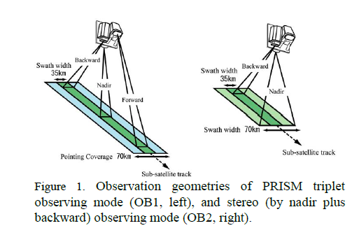
There are 3 CCD and 3 views in PRISM:
Oh, right. A product comes with several images.
Yet, if it was that easy, we would probably already have large parts of the imaged land processed to high quality DEMs.
Years ago a colleague was generating distances from stereo images. He was able to use open source photogrammetry libraries. These days drone images are used to generate DEM’s for small regions Creating georeferenced digital elevation models from unmanned aerial vehicle images using open source tools (Youtube, with references) and How can I create a Digital Elevation Model from satellite Images?
Thank you. There’s a lot to process in those articles - I’m on it 