Is there any generic way to work with SAR data to generate EDM ? Does SNAP help in doing that ? I have been following https://media.asf.alaska.edu/uploads/pdf/current_data_recipe_pdfs/create_a_dem_from_sentinel_1_v1.3.pdf , but all this is specific to Sentinel 1 data ? How to go about it in general ? Any opensource project? or software? I know the steps followed for sentinel-1 specifically , so I expect similar processing on the generic data, but with what ?
Thanks in advance for the help.
The only difference is the coregistration. You use the “normal” coregistration for any SAR data except for Sentinel-1. The rest is the same.
Have you seen this thread: The Order of DEM Creating Steps
Okay, so that should be the thing in the sequence
S1 Tops co-registration --> to be replaced by simple coregistration
Interferogram Formation
S1 TOPS Deburst --? ?
Goldstein Phase Filtering
Make the SNAPHU Export
Unwrap the interferogram with SNAPHU
Import it back
Convert Phase to Elevation to get the DEM
Whats the substitute for the S1 TOPS Deburst for the generic case ?
Also, any advise on good sample SAR data, except for the sentinel ?(so that I could best test my generic pipeline)
no debursting is needed for StripMap products (practically any other than Sentinel 1 TOPS)
Freely available Sentinel-1 and ALOS data:
https://scihub.copernicus.eu/dhus/#/home
https://vertex.daac.asf.alaska.edu/
Free TerraSAR-X sample data
https://www.intelligence-airbusds.com/en/8262-sample-imagery
Hi, Thanks. I have started with Free TerraSAR-X sample data (https://www.intelligence-airbusds.com/en/8262-sample-imagery) --> TerraSAR-X StripMap Grand Canyon - USA SSC HH.
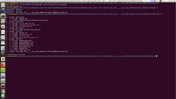
I have the following contents , so which ones are relevant for Interferogram and hence DEM generation ? I want to imitate the process as with Sentinel-1 Data, but there we worked with phase and intensity, but here it doesn’t seem to be the case.
It would be really nice if you could explain the file to be picked up from this(and parallely, other one will be picked up from the different data point , and the two would be coregistered to produce).
When working with Senitel, we had the products that had everything. I am not able to draw analogies between two folders.
And what were the VV , VH tags used with the Sentinel case ?
Many thanks in advance.
If you downloaded SSC products you have everything you need (although the phase is sometimes not displayed at first).
You import the DEM as a whole (file > import > SAR > TerraSAR-X), then coregister the scenes, create an interferogram, filter (and multi-look) it, unwrap it and convert the unwrapped phase to elevations.
@ABraun It worked, thanks. Except for the software SNAP, is there any similar way to doing this in python or any other language ( i.e. any python library/API supporting the same operations) ? Because I need to repeat for several files, and if I get the way to get this done with a code, it will help me work effectively.
Also, is there any advance literature DEM generation using SAR. I am absolutely comfortable with this, but are there any other algorithms or implementations which provide superior DEMs as compared to these ones ?
Thanks in advance.
@ABraun , please look at Snaphu Import Error once. I have used the above mentioned data set and process.
Automating the whole workflow is no good idea because you often need to check intermediate results and refine/adjust parameters. But you can use the graph builder to repeat parts of it.
There is a tutorial on DEM generation with python but the input data has to be prepared a bit:
https://eo-college.org/resources/dem_python/
The procedure is quite standard. ERDAS IMAGINE has a stereo SAR module but I have never seen a successful application of it to be honest.
ESA provides nice explanations on interferometry:
Here you will find three documents:
Part A is for readers with a good knowledge of optical and microwave remote sensing, to acquaint them with interferometric SAR image processing and interpretation.
Part B provides a practical approach and the technical background for beginners with InSAR processing.
Part C contains a more mathematical approach, for a deeper understanding of the interferometric process. It includes themes such as super resolution and ERS/Envisat interferometry.
