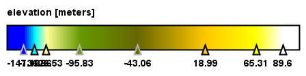
DEM generation of Sentinel-1 Data is showing negative elevation
I generated interferogram in SNAP Software and did phase unwrapping in SNAPHU but the result is showing negative elevation.
DATA Details:Sentinel-1 IW SLC products over the 2014 eruption of the Fogo volcano in Cape Verde.
SENTINEL-1
Data 1 Data 2
Acquisition mode IW IW
Antenna pointing Right Right
Incidence near 99,999 99,999
Incidence far 99,999 99,999
Range spacing 2.33 2.33
Azimuth spacing 13.997 13.997
Product Time 28-NOV-2014 14:05:34.340674 28-NOV-2014 14:35:25.183413
Radar Frequency 5,405 MHz 9,650 MHz
Pass Ascending Ascending