of course not. An Interferogram is the difference of the phases of two images.
Please have a look at the PDF tutorial, especially under the point “Coregistering the Data”
Thanks for your suggestions but maybe I did not explain well.
I know what the stack is and I know that interferogram formation provides the phase difference between 2 images, which is why I cannot make a single image.
My probloem is that I can only achieve coherence with interferogram formation.
So I was wondering if there is another way since I decided to process only one image and do the stack only after having done the separate unwrapping of the two images.
thanks.
The phase information in each single image is random (but deterministic) noise. It cannot be unwrapped or used for anything useful on it’s own. If you are interested this is a good starting point to the principles of InSAR:
You can also compute the coherence separately underRadar > Inteferometric > Products > Coherence Estimation
Thanks for your reply but I have already tried to obtain it throught “Coherence estimation” but I have always this error and I am not able to understand it
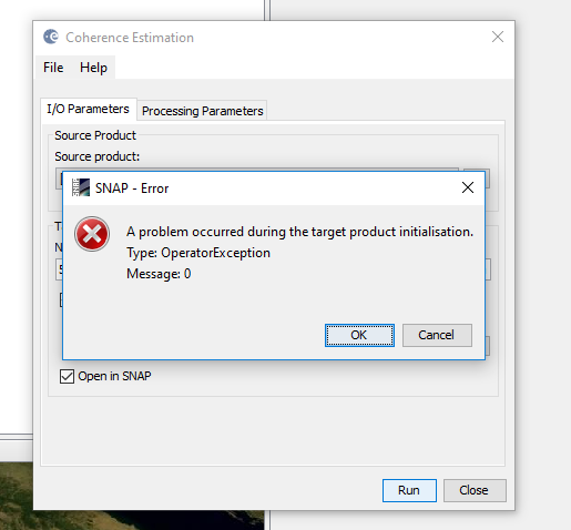
what is your source product for this process?
I have tried with two differents products.
The first is a product after TOP SPLIT-Apply orbit file-back geocoding
The second is a product after TOP SPLIT-Apply orbit file-back geocoding-deburst-goldstein phase filtering
The error is the same.
At a certain point snap said me that I had to update a plugin and that I have to install the version 6 of snap so I have tought that the problem was the version but I have installed the new version and the error is the same.
have you tried TOPS coregistration as well instead of performing all steps manually?
May I ask how you created the interferograms’ stack?
@ctheodor You can directly address users in topics with the @ symbol, just as I did in this case. This increases the chances that the correct person feels addressed and you get an answer.
Thanks a lot Dr Braun
@johngan May I ask how you created the interferograms’ stack?
Hi,
For stacking you need to do the following:
- Collect a time series SLC SENTINEL-1 images
- Perform InSAR analysis for each image pair
- Terrain correct each pair
- Create stack (Radar->co-registration->stack tools->create stack)
hello Johngan, I have finished all the steps in PS procedure,and get the PS displacement in stamps_visualizer ,the result shows like this:
what i doubt is the direction of the distance in the picture,it is a LOS distance or a vertical distance,if it is LOS distance,how can i convet it to a vertical distance.
all what i want to do is because i have get the LEVELLING data of my area ,so i want to compare the PS result to the levlling result
hi,FeiLiu, i also want to compare my ps result to levelling data,but dont know how to convert it to vertical displacement?
can you help me
SNAP cannot do that, but it has been discussed several times in this forum:
Mr. ABraun how can i change unit to mm. As you discussed above, kindly write from initial till end that how can i open a band math (unw_Phasewavelength in mm) / (-4PI* cos(red(incident_angle))) i have mentioned the band math but here i am not able to do any thinng.
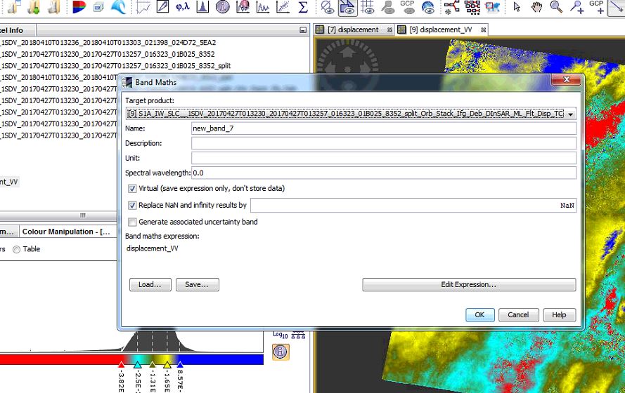
Its well described in this topic: Subsidence map in 3d view
You don’t need to change che unit, for example, instead of 3.1 [cm] you simply write 31 [mm]
Dear all,
How may I export ascii file including lat lon east north and up from unwrapped interfrogram in SNAP ?
Anybody has any idea?
Thanks is advance.
Hi, Mengdahl, do you can please say me what is the incidence angle over of the elipsoide?