I am working on glacier studies and aim to generate a contemporary DEM of my Area of interest (AoI) which is located in mountainous region of Himalaya. DEM generation with Sentinel-1 Tool is an effective document for DEM generation but for my AoI its hard to find data with high coherence which is most important for DEM generation according to said document. May I seek any guidance to develop DEM of a high accuracy even with low coherence using SLC data of S1.
the most favourable conditions are short temporal baselines and large perpendicular baselines.
Use the ASF Baseline tool to find an image pair with 6 days and > 150 m.
Also, it is often worth comparing results from ascending and descending products.
You can share your AOI and I can have a look.
Thanks for feed back, I used ASF baseline tool. Problem in that have to stick with summer season i.e July 15-Oct 15. I searched all the required scenes. I do have minimum base line with 12 days interval and 150 perpendicular. But for those scenes I am unable to have an over all a good coherence.
I just want to know that " Is it any way to generate DEM even with low coherence.
I have another limitation that is unavailability of S1B data for my AoI. I am enclosing shape file in a zip folder of my AoI for your consideration. I will thankful if you help be to resolve the limitation of Data for my AoI Hunza Boudary.rar (23.5 KB)
Low coherence indicates decorrelated phase. You need the phase information for the estimation of topography.
Have you tried these two:
S1A_IW_SLC__1SDV_20191005T125734_20191005T125801_029324_035543_9B9E
S1A_IW_SLC__1SDV_20191017T125733_20191017T125801_029499_035B49_51E3
They have 153 m baseline
I just downloaded the scenes and working on these but I am not confident to get good results. However, I will share the results in a while. May I seek you help to find topography using phase information plz
I’m afraid I cannot overcome the laws of physics either ![]()
Let’s put it like this: If it would be easy to derive elevations from Sentinel-1 - why hasn’t there been any officially released S1 DEM so far? Don’t put too much hope in it.
2 Likes
You are right, but our struggle is to meet target with limitations. S1 has potential to drive DEM for contemporary period with rest of data set used in research. In my case I observing optical data of Landsat 8 for months of July to Oct for glacier region and I want to see the topography at that time.
I wish you good luck that the areas which are relevant to you have good coherence. But even then, unwrapping is challenging, because it will not poperly work on isolated areas of high coherence. There should be a connection over the image at least,
1 Like
Hi
I have a question. Could you please guide me what to do.
I want a DEM file related to the top of trees and vegetations, is it available in any website or utility like Lidar, SAR, … (with good precision) to be achieved? Which of them do that for me with high precision?
The most important thing is to evaluate the height of trees or have the elevation of top of trees and vegetation. Is there any source for them, even if it is possible to download it or achieve it for different year?
Thanks for your guidance
I found these:
- Global Forest Canopy Height, 2019 | GLAD (umd.edu)
- Global 30m Landsat Tree Canopy Version 4 | LCLUC (umd.edu)
- ETH Global Sentinel-2 10m Canopy Height (2020) - awesome-gee-community-catalog
Mabe you find more when you search for it: Bing Search ‘tree canopy height data download’
1 Like
Dear
Thanks so much for your support. I have a question because I am not so much familiar with the surveying dat. Does is it mean that, for example for the “GLO-30” data , whereas the resolution is of 30 m, for every 30 m in the field (30 m length and 30 m width) we have just one elevation and data for that area has been averaged to an average one number for a square 30*30 m?
Thanks for your response
Referring my previous message, does it mean that I miss a lot of points in a square 3030 m and receive just 1 point for all the related area?5- Referring my previous message, does it mean that I miss a lot of points in a square 3030 m and receive just 1 point for all the related area?
Yes, this is generally correct. But I don’t know if the value is the result of an averaging or the result of a somehow random measurement in this 30x30m area.
This might depend on the specific data set. Probably there is some user manual available which explains it, if not you can ask the data provider directly.
Dear
Thanks for your support. I have a question because I am not so familiar with the surveying data.
Referring your guidance, I really need a DEM file from my study case (Abruzzo region in Italy) with a very high precision, even maybe around 1m or less. Could you please guide me how could I find it or even if I have to pay for it, what is the website that is related to these kind of data?
Thanks for your guidance and information
I look forward to hear from you
Amir Farshadfar
I’m sorry, I’m not aware of such a high-res DEM for Italy. The highest resolution you usually find is 10m.
For the United States there is a 1m DEM available. For Italy there are for example available the
- TINITALY, a digital elevation model of Italy with a 10 meters cell size
- Copernicus Digital Elevation Model - Copernicus Contributing Missions Online
You can create a DEM yourself, but as far as I know with e.g., Sentinel-1 data you will also only get a spatial resolution of about 10m.
Here some guides:
-
S1TBX DEM generation with Sentinel-1 IW Tutorial.pdf (esa.int)
How to Create a DEM using Sentinel-1 Data | Alaska Satellite Facility - DEM Generation using Sentinel-1 images in SNAP - YouTube
- High‐resolution DEM building with SAR interferometry and high‐resolution optical image - Hadj‐Sahraoui - 2019 - IET Image Processing - Wiley Online Library
Another option is LiDAR data, but it is hard to find and usually limited to a small area.
Maybe this is useful for you:
DTM LiDAR con risoluzione a terra 1 metro - Regione Abruzzo - Dataset - CKAN (sciamlab.com)
![]() Marco from EOMasters - Mastering Earth Observation
Marco from EOMasters - Mastering Earth Observation
1 Like
Dear
Many thanks for your guidance. I followed the link and it showed the cost for a high resolution 1.0 m or less is very cost effective even for the DSM or DTM data which would never be included in my budget.
Could you please guide me if there is any website that allows for point measurements and extraction of land and vegetation heights directly free of charge with a high accuracy specifically considering some defining year or even for a specific year?
Please let me know if there is any website considering charges also and I have to pay also?
Thanks for all your guidance and information,
Sincerely,
Amir Farshadfar
Sorry, I can’t help further.
Thanks for all your support and guidance.
-
If I could have the z coordinates of the area with the resolution < 3 m, it would solve the problem. I do not specifically needed the height of trees and vegetations, I just need the z coordinates of some limited points, even by considering the tree and vegetations, to solve the problem. Could you have any suggestion?
-
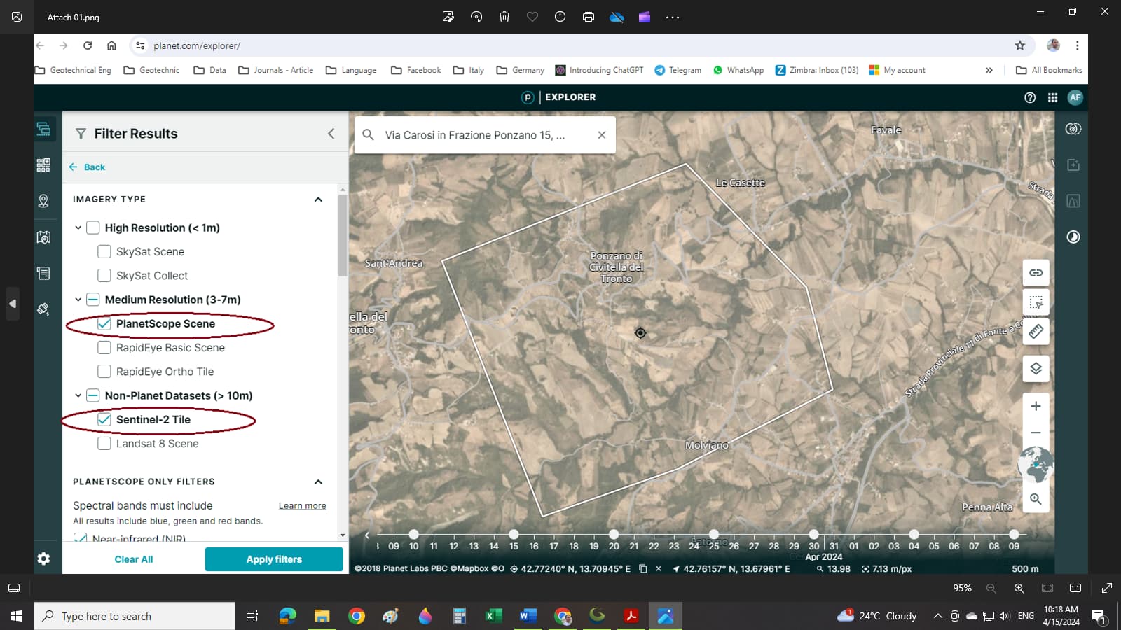
In addition, I fund the website named planet, which offers the free download academic account for resolution < 3 m, but I understand that I can use the “Sentinel-2 Tile” option to download the DEM data from the area (Attach 01), but with the resolution > 10 m which is a little low precision for me,
but the “PlanetScope Scene” option could download the data with the resolution < 3 m, which is very good for me, but it does not provide DEM data and if I want to create DEM data from that, I should use another stereo photogrammetry software to create this by myself.
I am really completely unfamiliar with surveying science, could you please guide me what should I do and which software is needed and how could I use the option “PlanetScope Scene” with < 3 m resolution to create DEM data? Does it have a difficult procedure to do it? Do you have any website to do it?
Thanks for your guidance and support,
I look forward to hearing from you,
Sincerely,
Amir Farshadfar