Hello,
I am running the Sen-ET plugin, but i have problems with Prepare ERA 5 reanalysis surface meteorological data with this warnings and error message:
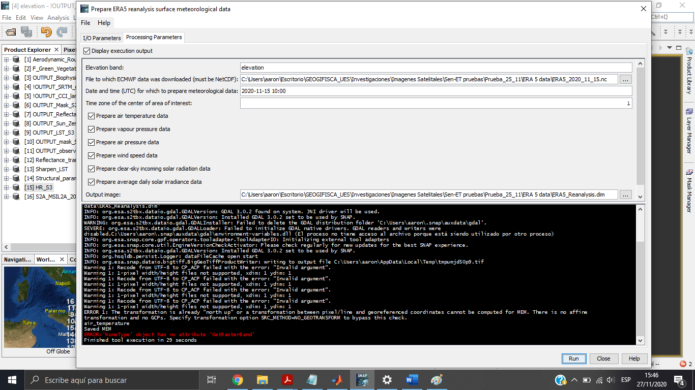
Warning 1: Recode from UTF-8 to CP_ACP failed with the error: “Invalid argument”.
Warning 1: 1-pixel width/height files not supported, xdim: 1 ydim: 1
Warning 1: Recode from UTF-8 to CP_ACP failed with the error: “Invalid argument”.
Warning 1: 1-pixel width/height files not supported, xdim: 1 ydim: 1
Warning 1: Recode from UTF-8 to CP_ACP failed with the error: “Invalid argument”.
Warning 1: 1-pixel width/height files not supported, xdim: 1 ydim: 1
Warning 1: Recode from UTF-8 to CP_ACP failed with the error: “Invalid argument”.
Warning 1: 1-pixel width/height files not supported, xdim: 1 ydim: 1
ERROR 1: The transformation is already “north up” or a transformation between pixel/line and georeferenced coordinates cannot be computed for MEM. There is no affine transformation and no GCPs. Specify transformation option SRC_METHOD=NO_GEOTRANSFORM to bypass this check.
air_temperature
Saved MEM
ERROR:‘NoneType’ object has no attribute ‘GetRasterBand’
Finished tool execution in 18 seconds
Im using SNAP 8 in Windows 10
Previously i got the results:
-> !OUTPUT_SRTM_elevation! from the add_elevation graph in the
POLYGON ((15.954193714758976 38.70998449884092, 16.058687961540997 38.70908500793357,
16.057502612684754 38.62855740105432, 15.953125316226906 38.62945432072315,
15.954193714758976 38.70998449884092))
-> ECMWF ERA5 reanalysis data from 2020-11-15 in the area of interest 16.058687961540997/38.62945432072315/15.954193714758976/38.70908500793357
Hi, the meteorological data has lower spatial resolution than Sentinel-2 or Sentinel-3 and it seems that you have a small AOI that corresponds to only one pixel of ERA 5 and which results in the error shown in your message. Try enlarging your AOI. For the thermal sharpening to be robust, the AOI should be larger anyway (around a third of Sentinel-2 tile as a minimum).
1 Like
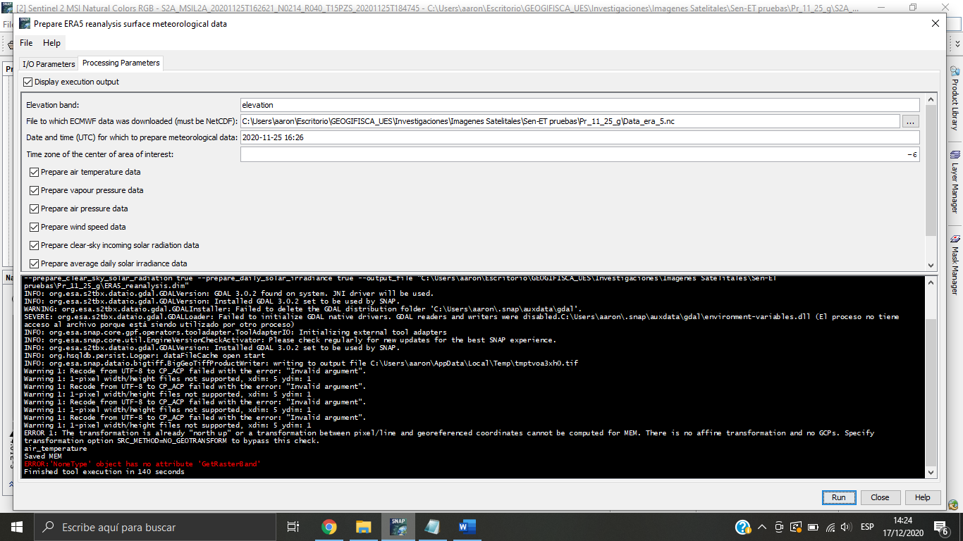
Im still getting the same error, on the last try I used an area of approximately108 km x 108 km.
POLYGON ((-90.20338780417852 15.356253994538243, -89.19067519957494 15.341241491641732,
-89.20778523909333 14.363994102547075, -90.21596610045303 14.378009116967801,
-90.20338780417852 15.356253994538243))
The S2 preprocessing process was completed, then i downloaded the SRTM DEM using de S2 Mask, and also the ERA 5 data was successfully downloaded.
I am using SNAP 8 with python 3.6
The issue is most probably with one of the inputs. Double check your inputs files (meteorology and DEM) by displaying them in SNAP to make sure that they both have sufficient extent, overlap, etc.
Hi Radoslaw,
Thank you for your reply. I have checked the inputs.
The DEM seems fine, I’m using SRTM that is already downloaded by SNAP.
For the ERA5 I download with the following inputs:
Envelope:
16.098388263094634/37.95450178326259/15.675256130860825/38.15547055396257
Dates:
2020-11-22
2020-11-27
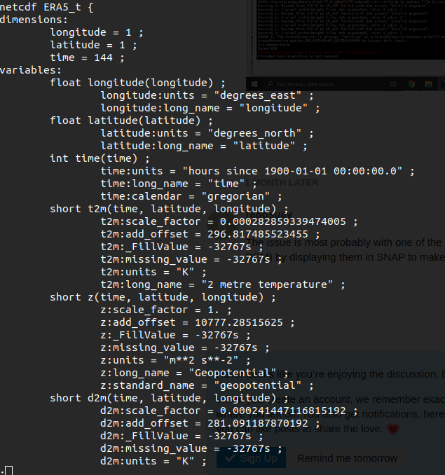
The download completes succesfully, however the file is just 8K and contains and when inspecting with ncdump, it shows just one latitude and longitude. Seems strange.
Is this expected? Are any of my inputs wrong?
Let me know if you need any other info.
Try extending the area for which you want to download the ECWMF data, e.g. so it’s a least 1 degree in latitude and longitude. The downloaded data volume will still be really low and the operator will automatically subset meteorological data to your proper AOI.
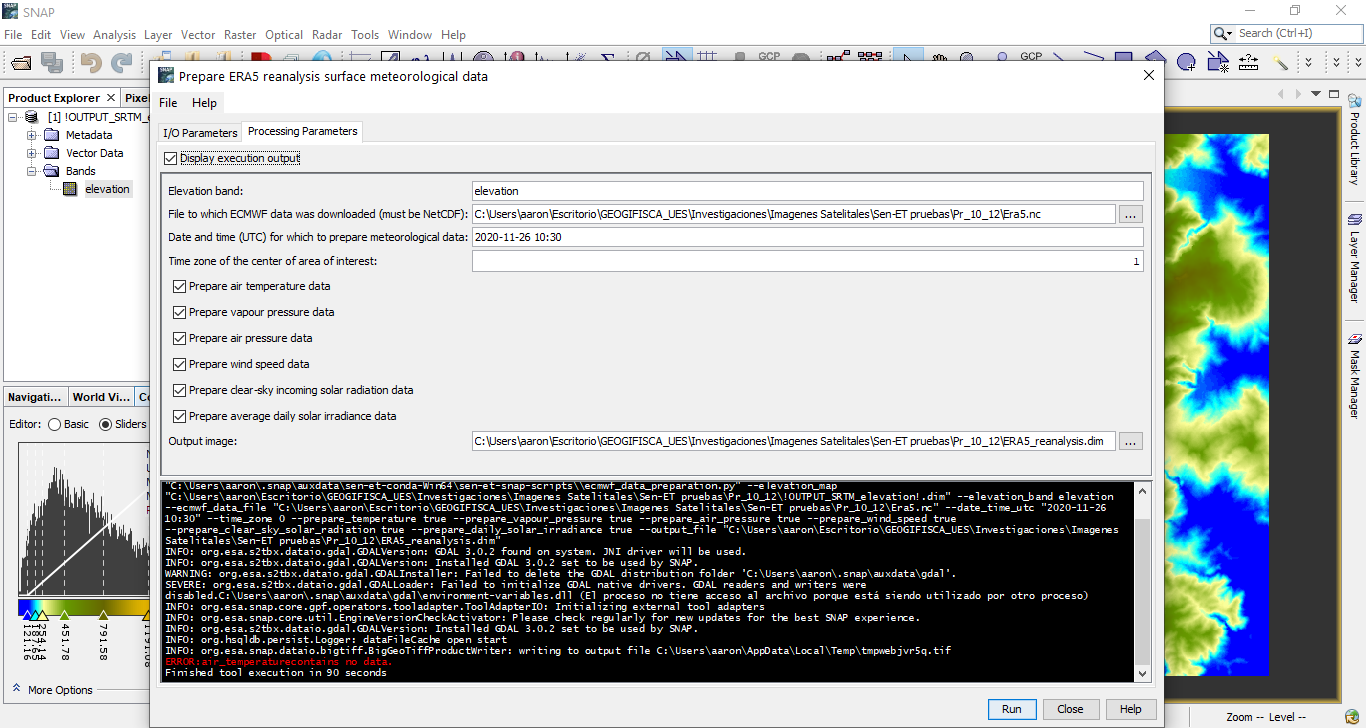
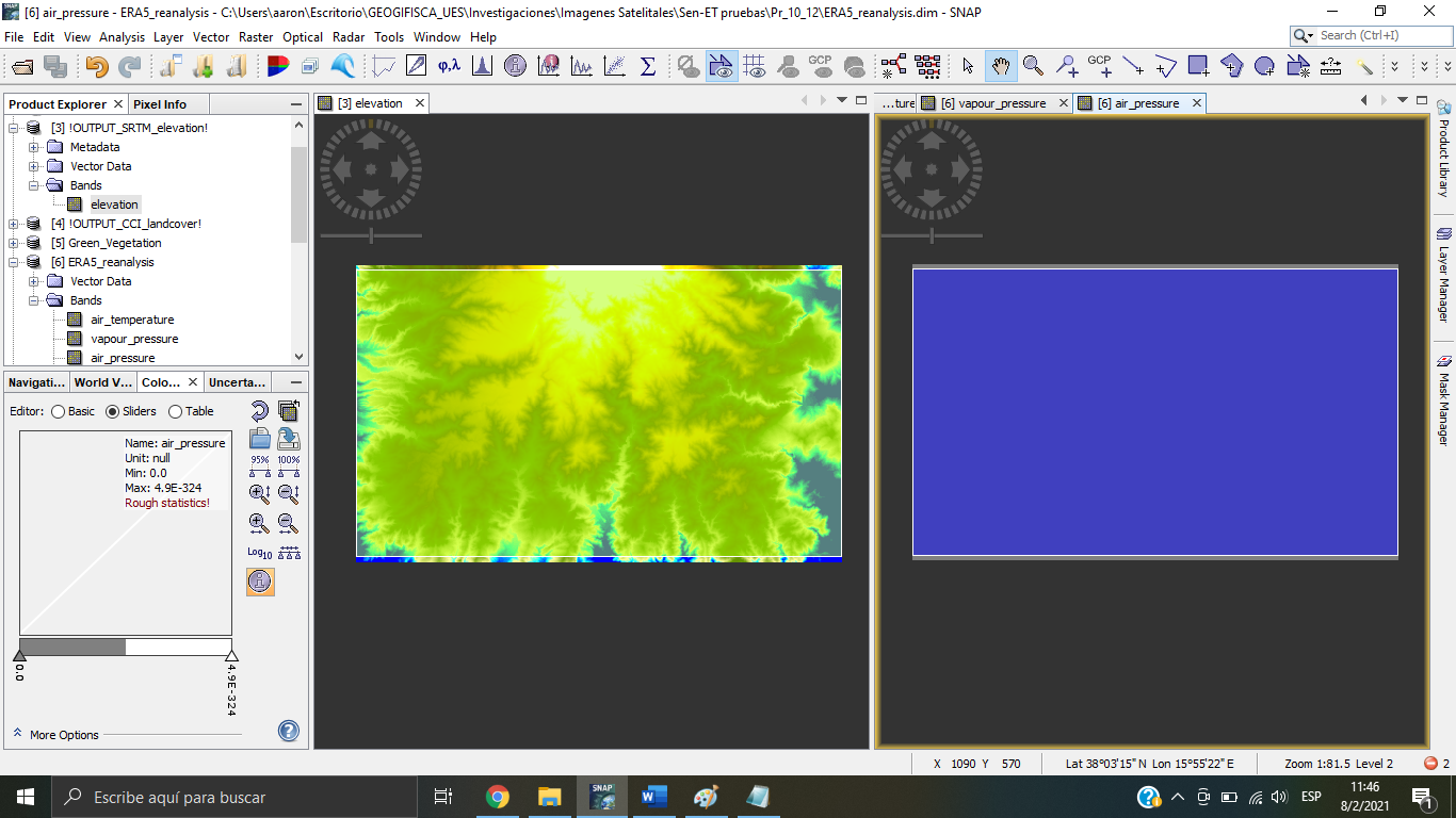
Thank you for the advice, i had completed the ERA 5 reanalysis process.
but i’m not sure about the output, they appear as one big pixel (blue rectancle in the image). Is the correct result for the AOI that i used?
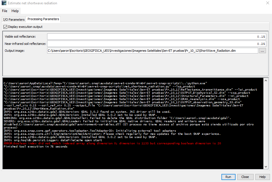
Also, i had problems with Estimate net showrtwave radiation. I’m getting this error
These are the results for the processes completed for cheking the error