Hi suribabu,
If the surface displacements are a combination of horizontal and vertical motion, then you can’t accurately calculate the vertical component from a single LOS measurement.
In this situation, you have two unknowns (horizontal and vertical) but only one measurement, so the problem is not possible to solve.
Hi @suribabu
Sorry for the delay. I’m not sure why do you get a different result from the Huang et al., 2019. Seems to be they changed a position of positive and negative values (That’s all about the geometry of sensors).
With ascending and descending InSAR geometries, we can obtain 2D decomposition, not 3D, so basically we have to work with vertical and horizontal displacement (E-W, because N-S is not so sensitive in InSAR, unless you work with MAI to retrieve azimuth displacement).
As @EJFielding said, to converting from LOSdesc to vertical displacement you have to be sure that there is no horizontal deformation, there could be a deformation masked by this motion, so the vertical displacement that you get is not good. But maybe, you can use that equation and compare with GPS. Also I suggested you compare the GPS LOS obtained from the both equations that I put in the comment and you equation from Huang et al., 2019 and see what is make sense to you.
In my case, horizontal deformation is very less. I think it will give better results for me. Dear @EJFielding @Simonst7, how we can get the incidence angle of existing PS points (file)? (There are several files created while running the StaMPS in Matlab)
Sorry, I don’t know about StaMPS output files.
One more formula from Khorrami et al., 2019 publication, GPS vertical to GPS LOS conversion. Please check it and any suggestions.
@panjibrotoisworo @Simonst7 @EJFielding @ABraun
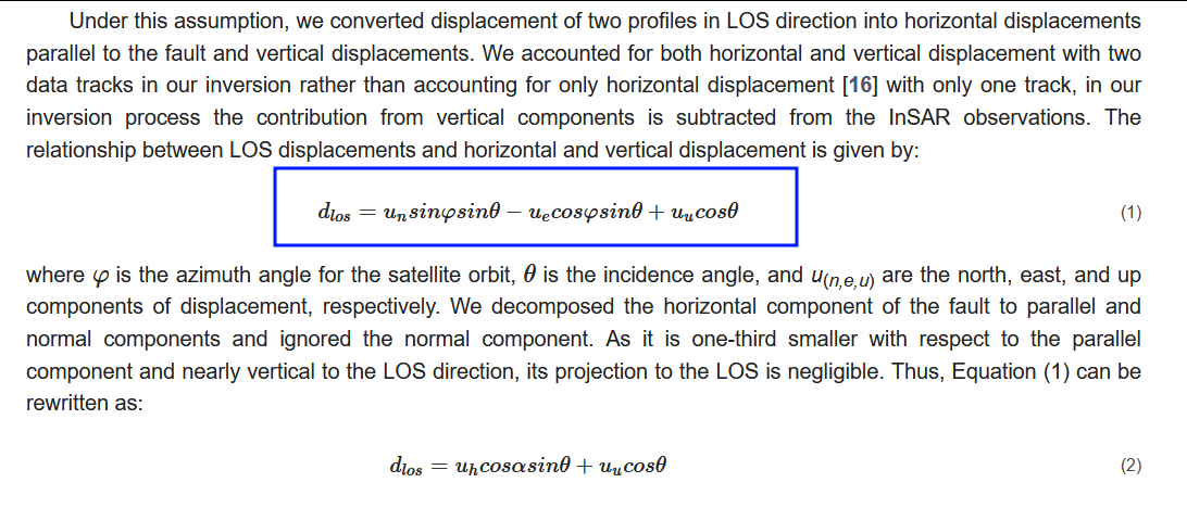
GPS_LOS = GPSup × cos(incidence angle)
−GPSnorth × cos(azimuth angle − 3pi/2) × sin(incidence angle)
−GPSeast × sin(azimuth angle − 3pi/2) × sin(incidence angle)----(1)
where GPS_LOS is the converted value of GPS data in LOS direction. GPSup, GPSnorth, and GPSeast are the values of GPS observation vectors in the up, north, and east directions. The radar images were taken from different incidence angles and the average incident angle is about 34 degrees in this study. azimuth angle represents the heading angle of the satellite from the North (azimuth angle) and is about 190.98 degrees in this study.
Reference:
Hanssen, R.F. Radar Interferometry: Data Interpretation and Error Analysis; Springer Science & Business Media:New York, NY, USA, 2001; Volume 2.
Yes, the forward calculation from three-component of GPS displacements to the radar LOS is exact, if you are using the local incidence angle and azimuth angle for each pixel. Note that particular formula assumes right-looking SAR, which is always correct for Sentinel-1 but not for all satellites.
Thank you @Simonst7,
What is the reference of this equation? I can’t find exactly this equation anywhere.
Hi @mosyhey ,
I remember I extracted that equation from some article related to measurements on a crustal fault using InSAR and GPS, but I can’t find the paper (it was last year).
Anyway, there are more examples using the same equation.
Here an example from Zhu et al., 2016 (Remote Sensing | Free Full-Text | Interseismic Deformation of the Altyn Tagh Fault Determined by Interferometric Synthetic Aperture Radar (InSAR) Measurements)
It’s the product from the multiplication of the given matrix eq., they ignored the N-S displacement by rewriting the eq.
Thank you so much dear @Simonst7 , That’s it.
