Is Apply-Orbit-File used for georefering Radar images?
I processed a S1 image and the output is not georefered… I cannot explain myself why…
Apply Orbit Files only updates the metadata of the product regarding the exact position of the satellite at the time of image acquisition.
To geocode your image apply Range Doppler Terrain Correction. Please also have a look here: Radiometric & Geometric Correction Workflow
Good morning ABraun,
So is terrain correction which gives coordinates info to the image, right?
I applied “terrain correction” with WGS84 reference system, the final image was without coordinates information, unfortunately
actually, the Terrain Correction projects your data into the selected coordinate reference system.
How did you open the result and what makes you think there are no coordiantes? What output data format did you select?
I chose JPEG2000.
I opened it on QGIS and the image was wihout reference system 
JPEG2000 does not always support internal geocoding, it is mostly stored externally as GeoJP2, for example. I’m not sure if SNAP has problems here.
https://gdal.org/drivers/raster/jp2openjpeg.html
is it an option to write a more common format first and then use gdal_translate, for example?
Many thanks for your reply,
I am not used to this format and I am discovering new things about it every day. I didn’t know about this behavior of JPEG2000 images.
I’d better remake everything saving the output as GeoTiff for example, right?
Yes, GeoTiff handles it much better. Stil, some of the metadata is lost. So if you are done with the preprocessing of the S1 data in SNAP, you can output to GeoTiff as a last step. But afterwards, you cannot use it as an input for SNAP tools such as speckle filter, for example. So sticking to the BEAM DIMAP format as long as possible makes sense. You can even open the img file of the output of Terrain Correction (located inside the .data folder) in QGIS without converting to GeoTiff.
Does it make sense to write the image on another format at the very end of this chain processing?
P.S. I exported the image in geotiff and it has the coordinates system on it! many thanks!
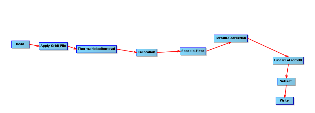
such long graphs are quite memory comsuming, maybe it is better to split it into two parts (with the subset at an earlier stage, maybe).
If you just want to use your data in QGIS, you do not need to export to GeoTiff and simply open the img file contained in the BEAM DIMAP product.
1 Like