In short - you unfortunately can’t. At least not with freely available Sentinel-1 data. IW Mode has a spatial resolution of 10 meters and SM mode one of 5 meters. As shown here, SM data is currently only collected at few locations.
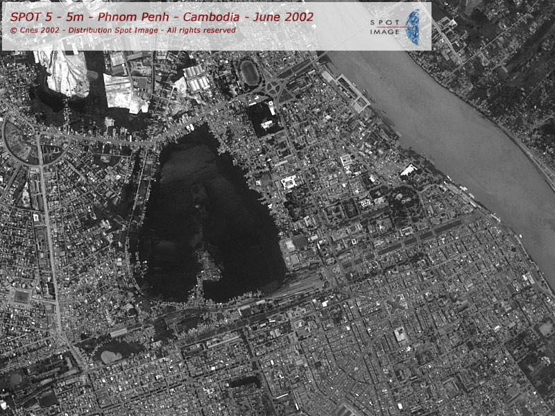
The image you are showing is a SPOT image. SPOT is a high-resolution optical satellite, that means it uses wavelengths in the nanometer spectrum (the light that our eyes perceive)
Radar satellites operate at a microwave spectrum, thus cannot achieve high resolutions as easily as optical sensors (or only at the cost of reduced coverage). Additionally, they are affected by speckle effects which make the image noisy. Third, they operate as a side-looking system which leads to geometrical distortions in the image which cause obscured areas (especially in urban environments).
Even if you would have very high resolution imagery (TerraSAR-X Staring Spotlight, for example) you will never get as sharp and complete images as the one demonstrated above. It’s a matter of physics.
You could, theoretically, use a stack of maybe 12 TerraSAR-X images with spatial resolutions of 0.25 to 3.5 meters and apply a multi-temporal filter. But each of these scenes roughly costs 2000 Euro.
I haven’t answered because I’m not sure by myself. So you would have to be patient for others to answer this, I’m sorry. Please don’t start multiple topics for the same questions in oder to catch more readers.
You should study the SNAP and S1TBX tutorials that are available online. Do terrain correction to 10m pixel size into the projection you need. The resolution should be close to the original ~20m of the GRD products.
Press the button (looks like magnifying glass) marked “P” in the navigation tool-window. This will show individual pixels in full display resolution. Then you can export your view to for example a .jpg with right-clicking on the image and selecting from the menus that pop up.
Yes, it is the same product, just different levels of zoom.
your level of zoom is completely independent from the spatial resolution or the pixel size. If you make a subset, the pixel size of the image stays the same.
Hello,
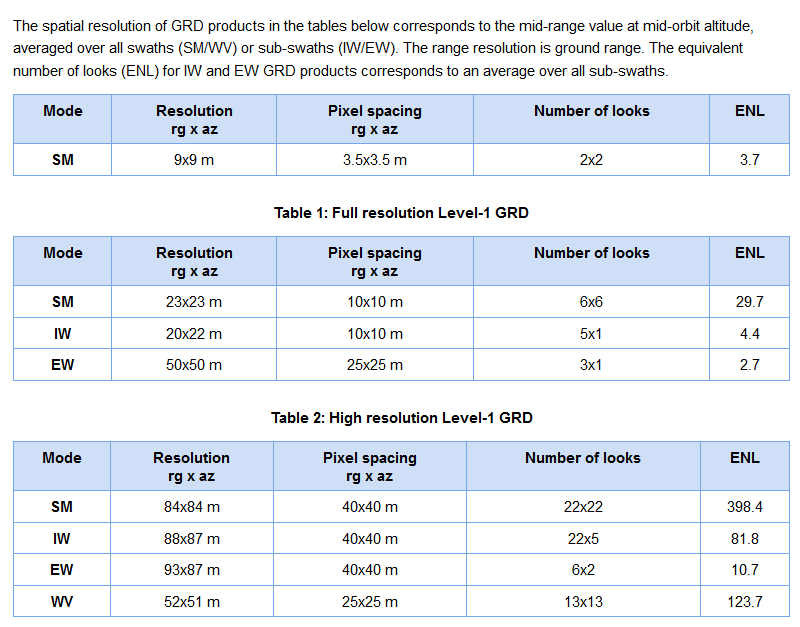
I have a similiar question as mast. I am being asked about the resolution of a processed image. Original product was Sentinel-1 Level 1 GRD product, IW swath. Problem is, that I used Multilooking proccess with 5 look in both range and azimuth. But does it change the resolution, if it is GRD product? And what number should I say? You know, if you are processing data from Sentinel-2, some bands have 10 m resolution, some 20 m and some 60 m. You have just 1 number there.
Thank you for the answers.
Thank you.
But I already used the process of Multilooking and I can not change it anymore. Is there a way to tell how much was the resolution changed? And is the value of spatial resolution 10 meters originally?
when you enter a number of looks in the module, you see the resulting spatial resolution. As GRD is 10x10, any multiple of looks is simply the corresponding tenfold resolution in meter.
2 looks = 20x20 m
3 looks = 30x30 m
4 looks = 40x40 m

