I am sorry I didn’t notice that. So what is the maximum difference in incident angle and central longitude and latitude of the images when they can be coregistered?
The easiest rule is, you can only coregister images of the same track. Only these have the same acquisition geometries and viewing angles.
2 Likes
Really like this tool!
Users which struggle with the size of SLC products andproducts and only need a small area for InSAR should check the latest update and the S1Crop tool which produces SNAP compatible complex subsets from unprocessed SLC data.
Does S1Crop work over burst and swath boundaries too? We should bite the bullet and make S1TBX to do this too…
Yes, at least in my test this worked. Quite handy I’d say
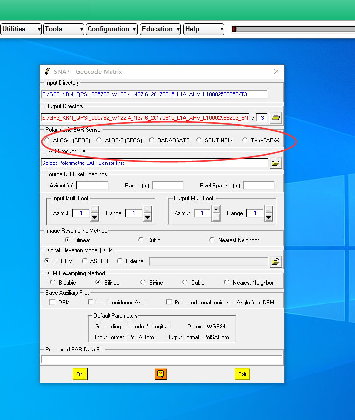
@xhuang, Hello, I would like to ask you a question. In the step of “Import DEM to GITASAR DEM Format”, I input downloaded DEM data in Original DEM and name the output file as DEM. Bin in GITASAR DEM.But there is such a mistake, please help me, thank you.

My ultimate goal is to do geocoding, but I find that the DEM data to be entered for geocoding is. Bin file, so I think it is necessary to convert DEM data in the previous steps, is that right?
If your python is configured correctly, this task should start automatically, but I had to copy and execute this command manually as well. But then it works and you get a DEM in the correct format which you can then use for further processing.
Thank you very much. Now I can geocode HH, HV, VH and VV respectively, but how can I use the encoded data in polSARpro? I find it seems that S11, S12, S21 and S22 cannot be coded in GITASAR.So what can I do to use geocoded GF-3 data in polSARpro?Thank you!
Wouldn’t it be easier to load GaoFen in PolSAR pro and apply the geocoding there? There is a link to SNAP which allows to apply range doppler terrain correction to complex polarimetric data.
PolSARpro can only read GF-3 data, and does not support geocoding of GF-3 data. There is no OPTION of GF-3 in the geocoding interface, as shown in the figure.Therefore, I want to geocode GF-3 first, but I don’t know how to import the data after geocoding into polSARpro。
oh, I see. I thought it would work for all sensors.
I’m not sure then, maybe @xhuang has an idea.
Thanks @ABraun for the quick answer. For @Canada-poet, I think GITASAR can geocode the S11, and S12 etc. Please check out “SAR Correction” -> “Geocorrection”. If you want to process the image one by one, you can use the “single image”, otherwise you can try “Multiple images”. Please remeber that the S11, etc are in complex format, that means you should use the “Complex” option instead of “Real”. Good luck!
1 Like
Thank you for your reply!But I don’t know why, when I geocode the IMPORTED GF-3 HH.bin, it works; when I geocoded the S11.bin produced by polSARpro,it will report an error.Please help me.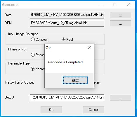
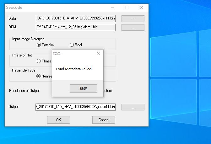
The s11.bin lack the metadata s11.xml. You can copy the HH.xml and rename it as s11.xml, that should work, good luck. @Canada-poet
1 Like
In addition, be aware of the data type of the input image if it is complex or real data type.
ok.Thank you so much.
Dear @xhuang
I am currently trying to coregister two Sentinel-1 SLC images. The download of orbit and aux files did not work with the provided scripts so I downloaded them manually.
Should I first create a subset with Import > Sentinel-1 SLC or should I directly use the Sentinel-1 coregistration?
Both tasks fail, am I using the wrong aux and orbit files? auxdata.zip (1.9 MB)
I am also not sure about the preparation of a DEM file - is it sufficient to convert it to ENVI format or should I also convert it to the S1 SLC geometry first before I can use it in the coregistration?
I am working with S1A and S1B so their burst numbers differ.
Hi @ABraun, thank you for the testing. If both S1 SLC has the same number of bursts, you do not need to subset both SLC data, otherwise, you might need to subset them to align them burst by burst at the current version of GITASAR. I am not sure about the AUX and Orbit file, but need to check them further. For the DEM, only converting it to the ENVI format with float datatype would be sufficient, no need to convert it to the SLC geometry. Currently, I am working on a new version of the GITASAR, which would be more flexible to handle those, but might take a bit time. Thanks again.
1 Like
thank you for your response. Another thing: Would it make sense (and is it technically possible) to correct for ionospheric effects in a single image pair of two Sentinel-1 products?