Good day dear friends from the forum,
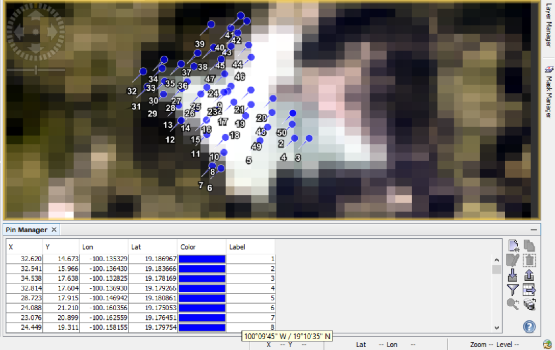
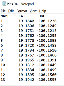
I am working with SNAP for mutitemporal water quality analysis, thus I need to analyse several products from different dates from MERIS (L1 and L2). I have the next set of coordinates (50 points, only shown 13):
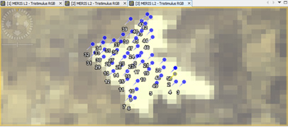
When inserting those coordinates in SNAP using the Pin Manager I got somehow different results and location for distinct products dates:
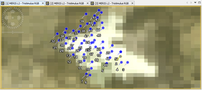
Date 1
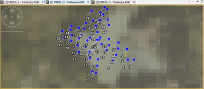
Date 2
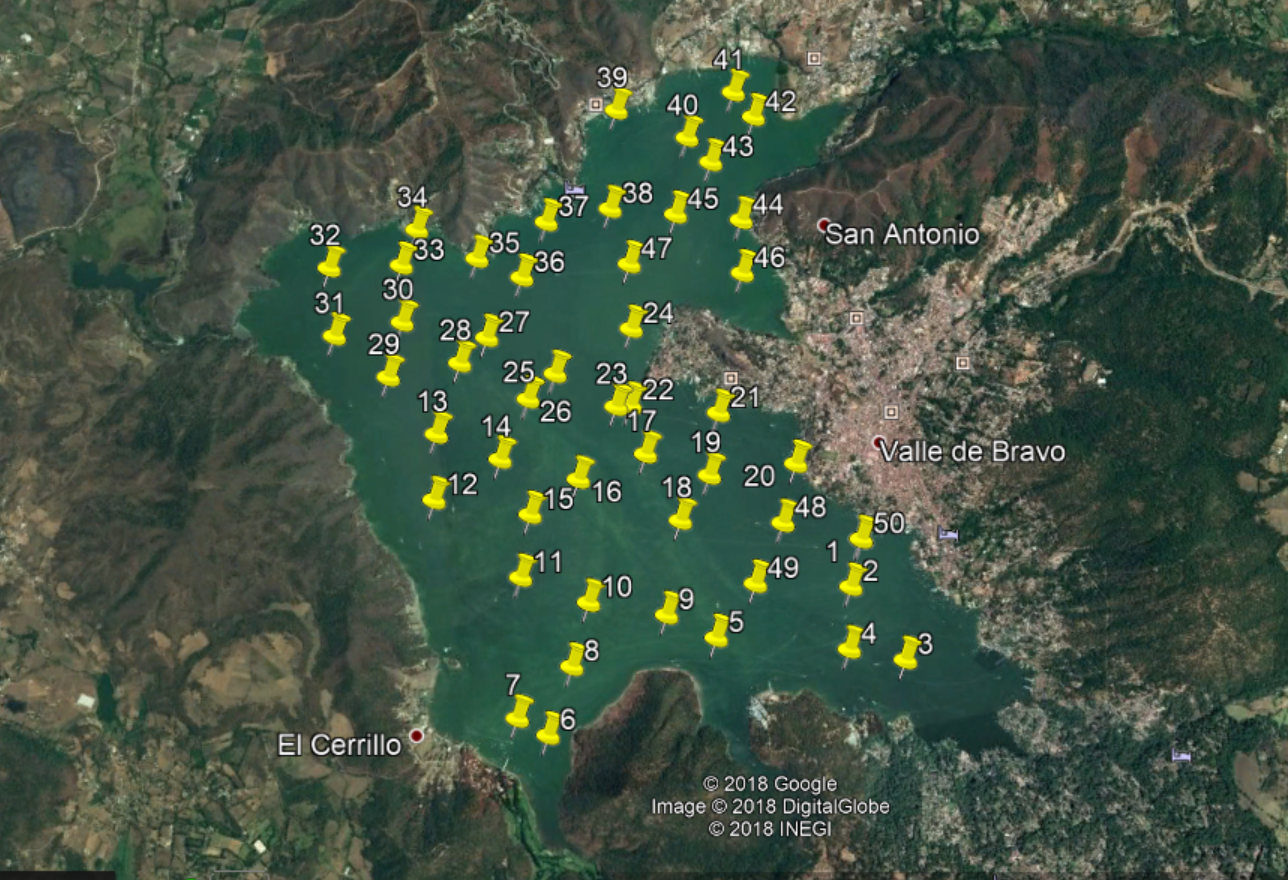
As you can see, the coordinates seems to be not in the same location on the waterbody for both images, in the Date 1 many of the points are out of the perimeter of the water, while this is not happening in Date 2. This can be particularly seen with Pins 39, 7 or 6.
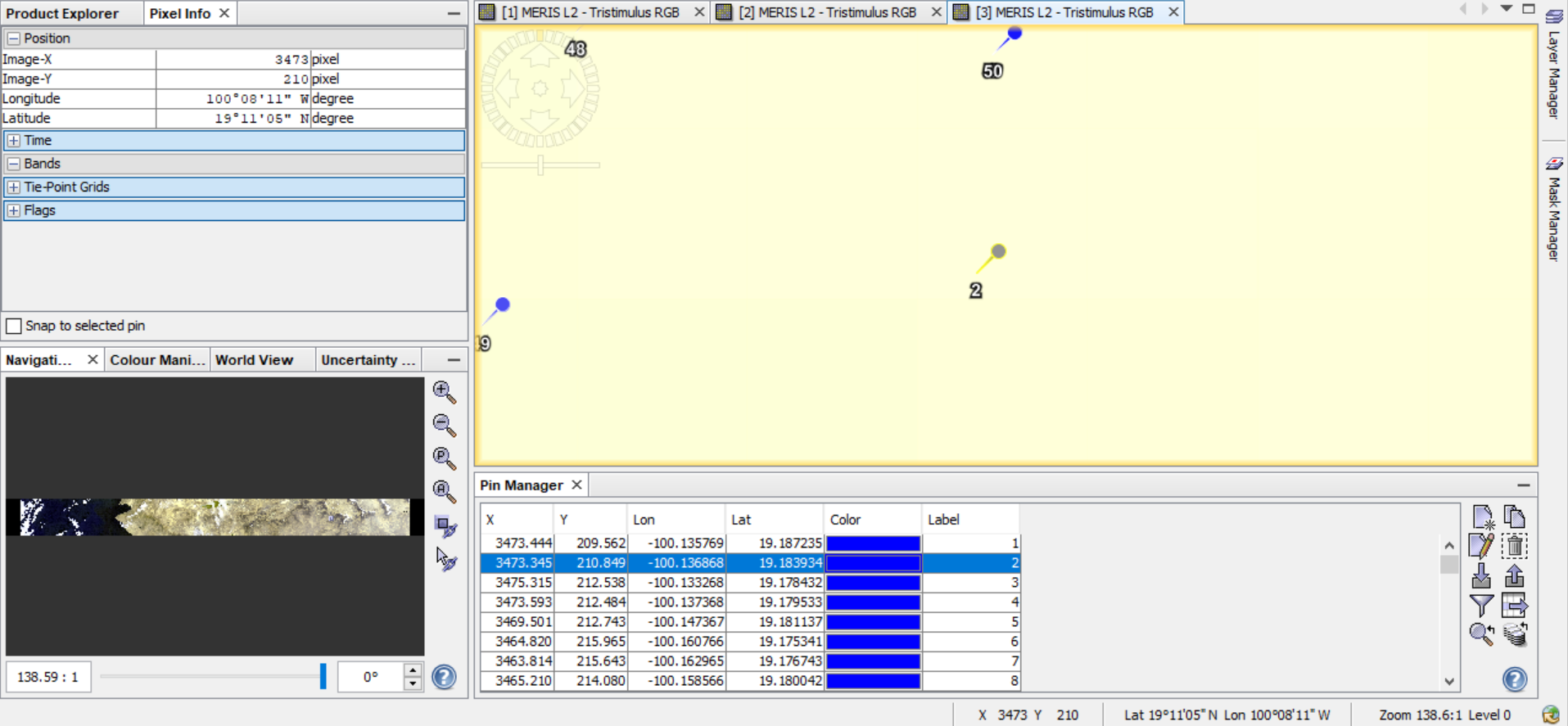
On the small label rectangle (down the number 8 in Label column) the W and N coordinates for the Pin 7 (100°09’45’‘W / 19°10’35’’ N) are shown. You can see that both coordinates are the same in Date 1 and Date 2, confirming the correct input of coordinates in both Products.
I have also tried to put this coordinates on other GIS (Google earth) having an overview of how they should look like:
The problem may increase due these variations could be present in more dates of products (not just between 2 as I show you here).
Do you know if I should do any type of Geo-correction in order to have always the same locations for different dates? if so, which one?
Thanks for your helps and comments,
1 Like
Dear Leonardo,
Once created the PINs associated to you image (date 1) you will have the possibility to export them in the PIN Manager Window clicking on “Export selected pins to XML file” and import them in the image (date 2) clicking on “Import all pins from XML or text file”.
If the PINs are displayed in different location, probably the images acquired in different dates have some problem in geolocation and you need to co-register the stack of images used as input.
Best Regards,
Fabrizio
Exactly, I have export them in the PIN Manager Window from text file (as showed in the first image).
The main problem is the PINs are displayed in different locations, thus there is no certainty for further analysis. This is happening in several images and not only in these 2 I used as an example. Thanks for your suggestion of the co-register of images. I will continue looking to solve this problem.
Hi Leonardo,
I am getting the same issue with Sentinel 3. Have you reprojected your Meris images beforehand? My pins vary depending on how I reprojected my images (i.e. subset before reprojection or not).
When you reproject, you can get a delta lat/lon band. I wonder if there is something similar to assess the original geocoding? Because we tested the collocation of the images, which obviously places the pins at the same location. But then, the position of the pins differs depending on which image is set as the Master  So which image to use as an input is the new issue…
I will be following the outcome of this post!
Max
EDIT: we also noticed that when the pins are imported in a non reprojected image, the lat/lon values of the pins are slightly shifted. I.e; the longitude 6.408 in the reprojected image becomes 6.412 in the same image that isn’t reprojected…
Dear Fabrizio,
Do you have any further recommendation or material to review about this process. Your suggestions can be very useful and valuable when trying to solve the problem of the PIN’s coordinates (Help with coordinate Input)
Thanks in advantage!
Cheers
Dear @leonardo.arias.27
could you provide the names of the two example products you are using?
Especially, if you are using RR, FR or FSG data. from the images I guess you are using RR, right?
If an orthorectification might help, depends on the area you are looking at. If it is in the mountains it can help. So in your case (1.850m) it is worth a try.
From your explanation, it seems the problem is in the data. Have you tried to visually locate the same pixel in both products and compared the shown geolocation?
Dear @marpet,
Thanks for your attentive answer.
The main work is based on the next FR products:
Product 1: MER_FRS_2PPBCM20100427_171020_000000172089_00012_42651_0001
Product 2: MER_FRS_2PPBCM20101003_171308_000000142093_00284_44927_0001
Product 3: MER_FRS_2PPBCM20110327_170802_000000173101_00012_47440_0002
Once having certain data for these 3 above mentioned products, in the research is also planned to use RR and other dates products of the MERIS’ archives for a multi-temporal water quality analysis.
I am using a single set of coordinates (attached)Pins 03 Original.txt (1.1 KB)
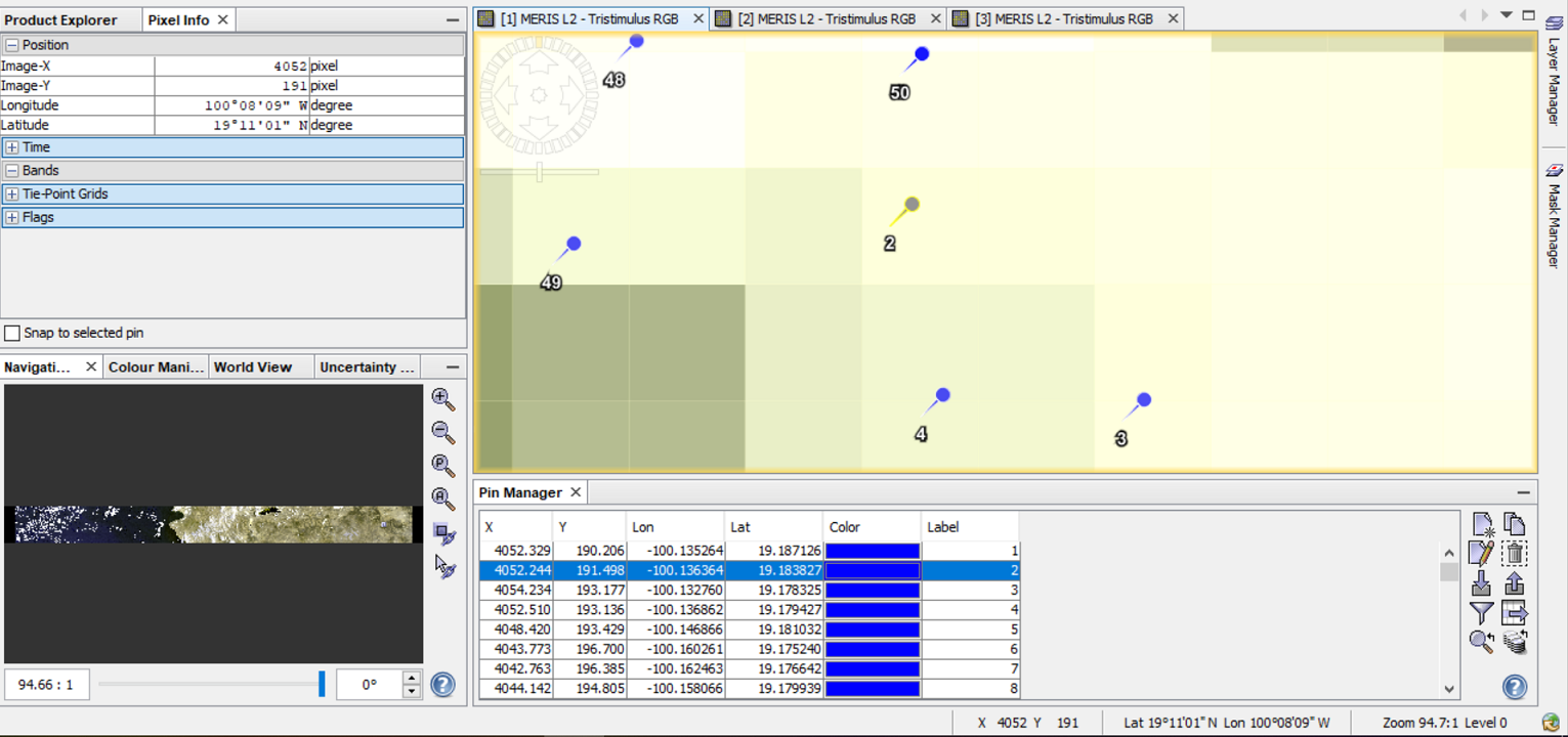
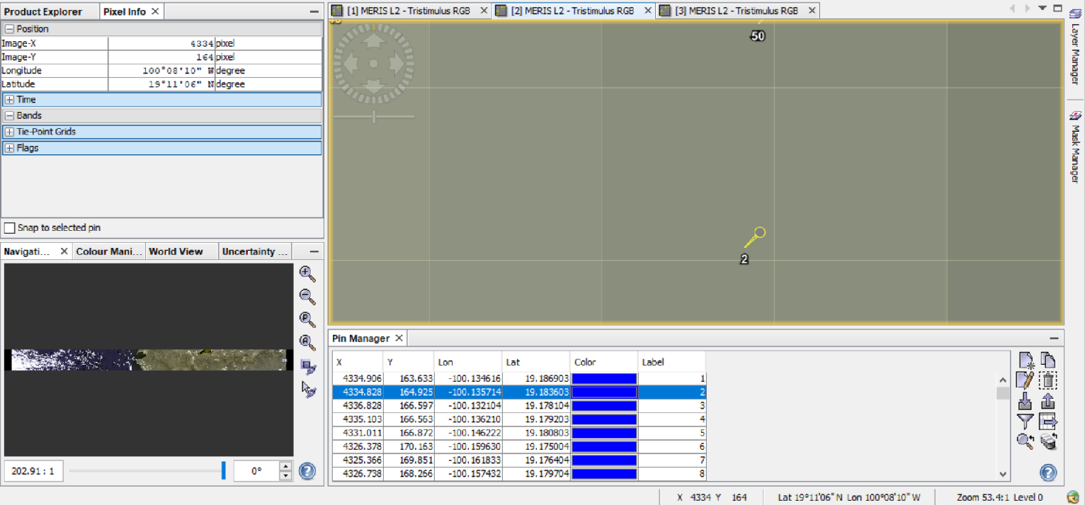
When using those pins directly in the above mentioned products, I am getting the next different LON/LAT in all the 3 products (PIN 2 used as example)
Product 1:
Product 2:
Product 3:
The overall view of the set of PINs is:
Product 1:
Product 2:
Product 3:
The correct location should be:

As shown, I have visually locate the same PIN (PIN 2) and the shown geolocation is still different in the 3 products. Locating pixels in a -easy to find- point of the reservoir, for example locations in particular changes in the shape of the water, is also giving different LON/LAT.
Thanks for the suggestion of the orthorectification. I hope the info here can be helpful to all of us users involved in this matter.
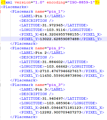
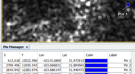
I have a similar problem that may or may not be related. The short version is, when I read a placemark file into the SNAP pin manager, the coordinates in the pin manager are not the same as what is in the placemark file.
I do this sequence of steps:
- Open a Sentinel-1 image (a SAR image) using SNAP
- Open the pin manager and create several pins. I entered the pin location using lat/lon, and the tool automatically filled in the pixel coordinates.
- Export the list of pins to a placemark file (an XML file)
- Open the placemark file in a text editor and verify that the pin locations in the file match the locations in the pin manager dialog box. Both the lat/lon and pixels coordinates match exactly.
- Close the STEP tool, open it again, and repoen the same Sentinel-1 image
- Open the pin manager, and import the same placemark file created in step (3)
- THE PROBLEM: The coordinates shown in the pin manager dialog box DO NOT MATCH the coordinates in the placemark file. They are close, but not close enough to be attributed to a simple rounding error. Neither the pixel coords nor the lat/lon coords in the pin manager match what’s in the placemark file. Also, the visual locations of the pins are slightly off in the image (by a hundred meters or so). They are consistent with what is in the pin manager, but are not (quite) the locations I used to create them in the first place. If anyone has an explanation for this, and knows how to fix it, I would appreciate it.
The first image below shows the first three pins as saved in the placemark file. The second image shows the first three pins after importing the placemark file into the pin manager. Neither the lat/lons nor the pixel coordinates seem to have been read correctly. For example, for pin 1, the pixel coords in the placemark file are (614.3206, 13022.6285), and in the pin manager are (613.018, 13022.596). The lat/lons have also been changed, from (31.9729, -103.9116) to (31.9729, -103.91186). This is an error on the ground of about 20 meters.
Hello,
I have the same issue. I am trying to import pixel pins in snap from a .txt file and when the coordinates are imported the longitude and latitude values change more often from the third digit that means ~from 100m and more. The pins are many, so is there a solution to not change the values of coordinates after importing?
THANKS a lot,
Anastasia
Hello!
I followed the recommendation of @marpet regarding the orthorectification. This solved the problem and I did have the need of other procedure to properly display the pins inside the surface of the reservoir. You can perhaps try this as well, just follow the menu:
Optical–>Geometric–>Orthorectification.
AlI the default settings remained the same and it worked for the MERIS images.
Hope it helps!
Leonardo