As a part of my minor project , I intended to detect the landslides. So we decided to study a singe landslide for it. For this single landslide,
1)from where can i get the rgb image of that landslide happened in past
2)how do i get DEM for that landslide
3)how do i get the slope image of that landslide
4)from where can i get time series data which is compatible with snap tool so that i can generate interferograms
5)how do i generate interferograms for that required landslide.
the below image describes the images that i have to generate from the rgb image collected from sentinel satellite
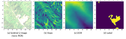
The label suggests the areas of landslide susceptibility and how do i generate this.?
Can you suggest me the way that I can do my project?
Are there any references that I can follow in this project?