Hello Marpet,
please how do i calculate ndvi using UAV acquired pictures?
thanks in anticipation
I can’t tell you specifically. I don’t know the sensor used to capture the images from the UAV.
But the calculation is always the same.
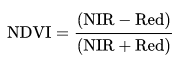
Where Red is the data at roughly at 670nm and NIR is at roughly at 800nm.
See Normalized difference vegetation index - Wikipedia
At this index database you can find quations adapted for several sensors:
IDB - Index: Normalized Difference NIR/Red Normalized Difference Vegetation Index, Calibrated NDVI - CDVI (indexdatabase.de)
In SNAP you can compute the NDVI by using the Band Maths (in menu Raster)